I completed the GEOG 291 quiz and reviewed the syllabus
Hello my name is Elliott Montana and I am a junior here at Ohio Wesleyan. I enjoy swimming on the swim team and going out fishing with my buddies. I am a Biology and Geography dual major hoping to pursue a career in natural resources/wildlife crime prevention. I think that the addition of GIS skills both as a desktop and online application will boost my career success in the field I plan to enter.
I have heard about GIS from several colleagues during my first year here at OWU and felt confused by what exactly it was and how it was used. My first interpretation is that it was solely a device used to make 3D maps. I now see that it is more complex than that and encompasses not just the technology used but also the analysis used to interpret the figures and data collected.
I thought that the idea of GIS being the “clearing of the fuzzy” was an interesting sentiment and made some sense to me. To me this translates to a set of decisions that help us define the distinct patterns that we can sense while viewing spatial objects through a geographic lens ex; what separates a mountain and a hill.
In addition to this I had not realized quite how much GIS is built into all the systems that function in our human society ex: The garbage routes and bike paths mentioned in the text. I had assumed that these processes were carried out by polling methods or simple measurements of distance covered.
I do not believe that my understanding of what GIS is has reached completion(I don’t believe anybody’s understanding of new and evolving things ever reaches 100%) but I think I will gain a better understanding of the concept over the next reading and practical hands-on experience with the technology.
Application 1
A GIS spatial analysis was used for several different factors in projecting habitat suitability for several species of marine fish in the Port Phillip Bay. The catch data was taken by fishing companies in the bay. Parameters measured include depth, substratum and sediment type.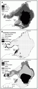
Morris, L., & Ball, D. (2006, January 1). Habitat suitability modelling of economically important fish species with commercial fisheries data. Ices Journal Of Marine Science. Academic.Oup.Com. https://academic.oup.com/icesjms/article/63/9/1590/696978?utm_source=chatgpt.com&login=true
Application 2
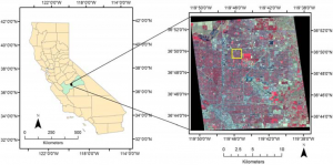
The next study aimed to identify swimming pools within an area using the Normalized Difference Water Index (NDWI) which works within a GIS system to identify standing water that is constituted as a swimming pool. The purpose of this is to identify places where mosquitoes might be breeding in an effort to combat the spread of the deadly West Nile virus.
APA Style
McFeeters, S. K. (2013). Using the Normalized Difference Water Index (NDWI) within a Geographic Information System to Detect Swimming Pools for Mosquito Abatement: A Practical Approach. Remote Sensing, 5(7), 3544-3561. https://doi.org/10.3390/rs5073544