- Introduction: Hello! My name is Payton Andisman. I am a senior majoring in Biology with a minor in music performance. Outside of classes, I enjoy being involved with theater, fitness, and listening to podcasts. I am taking this class for its skills that can be useful in the environmental science fields.

-
- Schuurman reading comments and thoughts:
I learned that the roots of GIS date back to the 1960’s where early visualizations were done by hand and not computer. Unlike Spatial Analysis that generates information from maps or data alone, ‘mapping’ represents geographical data, with varying degrees of consistency, in a visual form. It does not create more information than was originally provided, but does provide a valuable means for the brain to discern patterns. Over the course of its development, modern GIS is an outcome of both social and technological developments. GIS is a tool of visualization that is governed by the human interpretation of data and computer algorithms, allowing for the intuitive understanding of data. I noted Schuurman’s description of the “love hate relationship” with GIS because of its faults and biases, indicating how even with the advanced computing technology, it is up to the understanding of the assumptions used to govern the compilation, analysis, and visualization of the data that determine how accurate or applicable the data is.
I was intrigued by a portion of the first page: “philosophical implications of using GIS for research, planning, marketing, environmental management, or other tasks.” I was curious how this would go on to be described because “philosophical” wasn’t the word that I expected to be paired with a data compiling software. Before reading on, I wondered what similarities and differences might be involved with the implications of GIS software for important studies vs. the moral concerns of AI software.
Additionally, the introduction articulated that GIS’s reach lies far beyond the boundaries of scientific research and extends into a vast array of fields. Use of this software and understanding of its methods can be a valuable tool for many careers, projects, and of course, scientific data.
3.
Application: A personal interest of mine is the field of coffee growing and roasting. I looked into GIS and coffee farming on Google Scholar and found many examples of GIS being used for the study of and planning for coffee farming.
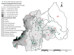
This map shows: “Potential Arabica coffee yield (t ha−1) predicted using ordinary kriging in the ten agroecological zones based on actual yields (tha−1) measured at sample sites.” https://journals.plos.org/plosone/article?id=10.1371/journal.pone.0107449
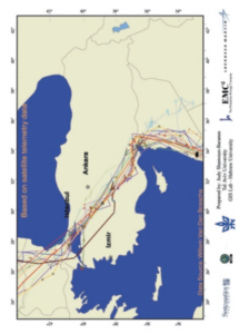
Another application that GIS can be a part of is the study of animal migration. This map “shows the migration routes of White Storks fitted with transmitters received by satellite over Turkey. This data can be used by the Turkish, Israel, US, NATO Air Forces, to avoid collisions with migrating.” https://www.researchgate.net/profile/Judy-Shamoun-Baranes/publication/267385744_Development_of_a_GIS-based_Bird_Model_Migration_Model_for_the_Middle_East/links/54c0df870cf216