Chapter 6:
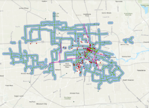
This chapter was meant to focus on collaborative mapping, using ArcGIS Pro, ArcOnline, and the app ArcGIS Field Maps to manipulate data (shapefiles), publish maps, and input data across interfaces. The chapter starts out okay but there’s a domino effect of errors that unravels quickly. I pretty much had the same issues that Holling and the others specified. For instance, I was able to get one tree symbol, but I wasn’t able to figure out how to change its status value or add more trees. I also had errors when trying to publish features such as the topography layer not being supported. I wasn’t able to figure out how to publish my map as the book instructs, so I eventually was not able to proceed through the rest of the chapter. Instead, I decided to read through the remaining instructions and follow them as much as I was able.
Chapter 7:
This chapter deals with geocoding or the process of transforming a description of a location such as a pair of coordinates, an address, or a name of a place to a location on the earth’s surface. This chapter has you analyze data from Houston, Texas to perform geocoding tasks such as symbolizing by color for median household income and creating buffers around bike lanes. Something was wrong with my median household income data and I wasn’t able to tell if it was joined properly. In summary, I did not have as many problems with this chapter compared to the others and I admired its examples of proximity analysis.
Chapter 8:
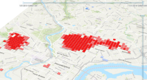
Chapter 8 covers analyzing spatial and temporal patterns by having you create a kernel density map, perform a hotspot analysis, visualize the hotspot analysis in 3D, and animating the data. I came across a couple of problems with this chapter, but they were mostly manageable or resulted from my own errors. For some reason, I had more crimes for the robbery_jan layer when selecting by attribute than what appears in the book. I made sure the date range was the same, so I am not sure what went wrong. Animating the data was weird. I could not tell if the animation was just being choppy but running properly or whether I had messed up somewhere in the instructions. I retraced my steps, but I did not notice any errors. All in all, it was interesting to see how the interpretation of the map could easily change when converting it to 3D and by editing the symbology making the 3D map more readable.
Chapter 9:
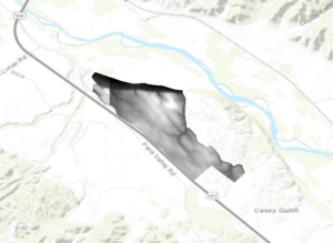
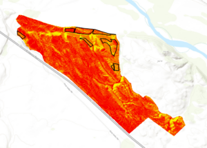
Chapter 9 instructs how GIS can be used to determine which areas are most suitable for a land-use change/purpose, a common use for GIS. This chapter took me a while, although some of it was more so review for me as I have performed some of the many of the same functions under other GIS projects that also dealt with determining suitability. You first start out the chapter by learning how to use the Extract by Mask tool to clip a digital surface model or DSM. The chapter then teaches you how to merge raster layers (the DSMs) by using the Mosaic To New Raster tool. The rest of the chapter deals with analyzing the landscape for suitability through various means: aspect, slope, and hillshades.
Chapter 10:
Chapter 10 details how to properly present your generated maps by showing you how to optimize your symbology and create a readable page layout. I had some troubles in the first half when altering the symbology, some resulting from the change in interface. One error I had was that the different values had the same color symbology even though I selected Unique Values. I figured out that I was editing the wrong layer because I had them named wrong. After I used the right layer, the problem solved itself and I was able to get different colors for the varying values. Formatting the page layout for the final maps was a review for me, but a much-needed one. I already knew how to add a north arrow and legend, but editing them as well as adding the spatial reference was informative. I had a problem adjusting the maps to the areas of interest so I adjusted the map manually by comparing them to the images in the book. My resulting maps resemble what the book has, but they are not exactly the same. In conclusion, this was a good chapter even though I encountered some problems, and I believe this is the best topic to end on.