Luna – Week 1

Hello! My name is Lydia Luna. I am a sophomore Zoology/Environmental Science double major from Mount Vernon Ohio. On our campus, I am involved in Greek Life, Panhellenic Council, Campus Programming Board, and the Admissions Office.

As I read Schuurman Chapter 1, I initially found it very exciting (or as exciting as a book like this can be) that the author of this text is directly aiming to instruct not only technically-skilled individuals but also those (like myself) that may not be overly familiar with this kind of program. I also found it interesting that the author explicitly talked about all of the different roles that GIS can play in society, which furthers the idea that GIS and this text specifically are not only for the people that you would automatically think about. I also really enjoy when someone that is teaching a topic can not only see why their work is important, but also the flaws in it. Reading the author addressing the flaws in these programs makes it seem like when I inevitably get frustrated in the process of learning how to use them, I’m not alone, which is an oddly comforting feeling. The explanation of the two components of GIS was new to me, with there being a “systems” side of things and a “science” side of things. It was very interesting to learn about how GIS can mean different things to different people, even outside of the different core uses. On top of that though, the authors also discuss the overlap in the two, which revolves around the concept of space. Once the space is officially called data, then it goes into the two components, whether to be collected or classified. It shows that while all of this kind of stuff can be very different and can be used for many different purposes, it all comes from the same core data. As a whole, this chapter just made GIS seem much more approachable and useful, no matter what career field I choose to go into.

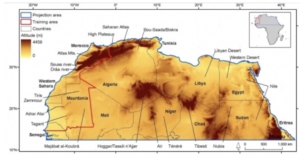
One of the applications of GIS that I looked into was in the realm of conservation, as I am interested in the use of environmental science in the zoology world. In the article I found, GIS was used to observe the changes in the environment in Northern Africa in order to explain the changes in biodiversity there. I also looked into the applications of GIS in water resources, which gave me an article about how the program can be used to model the way that water management would work in different locations before actually installing different methods.

Sources:

  1. Brito, J.C., Biogeography and conservation of taxa from remote regions: An application of ecological-niche based models and GIS to North-American canids. Biological Conservation 142, 3020-3029 (2009). https://doi.org/10.1016/j.biocon.2009.08.001
  2. Tsihrintzis, V.A., Hamid, R. & Fuentes, H.R. Use of Geographic Information Systems (GIS) in water resources: A review. Water Resour Manage 10, 251–277 (1996). https://doi.org/10.1007/BF00508896

Graham Steed – Week 1

Hello everyone!

My name is Graham Steed. Yes, that baby is me (I still wonder what made me so happy; maybe grass, trees, and sustainability, but most likely my mom). Anyways, as I was saying, I am a 2023 senior majoring in Environmental Studies. I am from Marion, Ohio, and I currently live in the Service Engagement and Leadership (SEAL) SLU. I am excited to take this class because I think ArcGIS is an important application that has so many real world uses, so why not learn more about it.

In regards to Nadine Schuurman’s GIS: A Short Introduction, Chapter 1, I found this reading to be both informative and interesting. Although I had previously heard of the debate between GISystems and GIScience, I now understand why making a decision is quite confusing. Personally, I find the theoretical aspects of spatial divisions found in GIScience to be the most fascinating because this is something that historically has been neglected, even in the early days of GISystems. Additionally, in my opinion, I believe GIScience attempts to clarify what the author says is “fuzzy” phenomena, which we have a hard time demarcating, if at all. 

Also, Schuurman discusses the technical history of GIS. What I found to be the most intriguing portion of this section was the author’s description of Ian McHarg’s methods for analyzing a particular space. To me, it is interesting that we still utilize McHarg’s “layers” approach in a digital environment. Furthermore, I was surprised that McHarg was able to get the results he was looking for by just using paper shaped into different forms. 

Finally, Schuurman explained the different uses among different organizations, such as municipalities, governments, and companies. I think it is awesome that you can map and analyze concrete data like waterways, public transportation systems, bicycle paths, public buildings, et cetera, but also abstract data like religion, income, and race. It is also extremely neat how geographers can utilize GIS data to predict future events like natural disasters.

In looking into GIS applications, I researched two topics of interest: food safety and income inequality. I found out that GIS can be used to plot human epidemiology and public health, agriculture, plant and animal health, and environmental factors that can determine overall food quality and safety in a given space, which helps companies and health professionals better protect consumers. In addition, I discovered that you can utilize GIS to plot income levels, which assists a wide range of researchers in answering questions in public health, economics, and government.

Sources:

https://hub.arcgis.com/maps/UrbanObservatory::income-inequality-in-u-s-counties/about

https://www.proquest.com/docview/2741249913?pq-origsite=summon

Cox – Week 1

Hi everyone! My name is Hannah Cox and I am a Junior environmental science major and zoology minor here at OWU. I am from Orange County, California. Some of my hobbies include lacrosse, reading, and anything related to sea turtles!

Shuurman Ch.1 Thoughts:

When I initially began reading this chapter by Shuurman, it was clear that GIS is a multidimensional software with many different uses for many individuals. That is the beauty (and sometimes faults) of having a program like GIS because it can be used so broadly depending on what it is needed for.

I really appreciated the section discussing spatial analysis, separating it completely from mapping because of the large differences between them. Although spatial analysis and mapping can intersect, spatial analysis generates more knowledge than what can be interpreted from maps or data. The author made it clear that when having GIS, you must understand how to frame questions to implement a successful quantitative model and if it is sufficient in the context of the available data. 

I was intrigued by the terms GISystems and GIScience. GISystems contain components like data input, analysis, mapping, etc., whereas GIScience is simply a theory that underlies GISystems. Having each GIS followed by systems or science represented the interrelatedness as well as how fuzzy the distinction can be between them. 

I enjoyed reading the last section of the chapter discussing the various ways GIS has been used. It is really amazing how GIS can be used to help various businesses, municipalities, and cities/urban areas. GIS is a fantastic example of how the digital world can help organize and fix real-world problems.

Google/Google Scholar GIS Application:
I sought out how GIS can be helpful in sea turtle conservation.

In my search, I found that the Florida Fish and Wildlife Conservation Commission monitoring marine turtle mortality and identifying the mortality factors in Florida since 1980. Between 1980 and 2022, there had been 53,444 strandings consisting of turtles found alive, injured, or deceased. Data was taken around all of Florida with the image showing the bottom south of Florida.  GIS can also be used to visually represent nesting data during nesting season along a known nesting beach.

Sources:

https://hub.arcgis.com/datasets/myfwc::sea-turtle-strandings-florida/explore?location=26.513152%2C-81.516692%2C7.21

https://sjcfl.maps.arcgis.com/apps/Viewer/index.html?appid=1d8d52ed9d5744659daacc32912c3eb1

DeMaggio- Week 1

Hi Krygier! You already know who I am from last semester, but my name is Jacob DeMaggio and I am a freshman here from Saint Louis, Missouri. I am an Environmental Science majorr (possibly a double major in Zoology) and additionally a Spanish minor.

When reading Schuurman ch. 1 I thought it was very insightful how at the beginning of the chapter the author addresses the matter that GIS has multiple identities based on who the user is and what questions they’re asking. To me, it not only showed how GIS can have multiple different “identities” but also how there is no exact way to pinpoint a definition of GIS that everyone will agree upon.  Additionally, I found it interesting when there was a brief discussion on what spatial analysis is and how it differs from mapping and GIS, how it extracts more data and information than can be gleaned by map data. I specifically find this interesting because I would always think that spatial analysis would be the same as mapping data. I also find it interesting that there were multiple different people, from multiple different areas (the U.S., Canada, and the UK) and how many people believed that the development of GIS was inevitable. It started to make me think about how our world today would be different if we didn’t have GIS, and it made me realize how much we use it on a daily basis in our cars every day, and for us to not have had that would have made everyone’s lives so much worse, which showed me how grateful I am to be in a time where GIS does exist. On page 7 the author quotes someone that uses an analogy of GIS and a calculator and helped make more sense of GIS. The analogy was that both are fairly straightforward and clear-cut as to what they do, but you have to understand all of their functions and intricacies of them before being able to effectively use them. It also has been shown throughout the reading that it is evident that there is a difference between the quantitative implications of GIS as well as the cartographic implications of GIS and also the relationship between the two of them.

When looking for GIS applications, I looked at the application for members of the LGBTQ community, and it discussed how with GIS we are able to make relationships between sexuality, place, and space. It goes deeper into how “queer space transgresses the normative and challenges (hetero)sexualized space”. Another GIS application I looked at was for crime-related GIS applications and I found that you can us GIS to create a map that can identify where the crimes are occurring and clarify what crimes are or are not related based on your research, which in turn can allow investigators to target their efforts and line officers to patrol and respond to locations while being more fully aware.

Gender Identity and Sexual Orientation Data is Now in Living Atlas

Sources:

https://community.esri.com/t5/conservation-gis/why-should-gis-matter-to-queer-people/ba-p/1011618

https://www.esri.com/content/dam/esrisites/sitecore-archive/Files/Pdfs/library/brochures/pdfs/crime-analysis.pdf