Hello! My name is Abbey Setlik and I’m a senior Zoology Major. I’m originally from Herndon, Virginia. I’m taking this class to better understand how GIS works since it seems to be a valuable tool for future jobs. This summer I worked in Dr. Wolverton’s lab and helped move my siblings into college. They are quadruplets so it was pretty busy. I am interested in field biology and wildlife rehabilitation.

I liked how the reading focused on how GIS is used in many different practices. As someone who is not very familiar with GIS, I was confused about the difference between spatial and geographical analysis. The author also explained how there were two ways to approach GIS: “where” spatial entities are and “how” we encode spatial entities. I believe, as someone interested in scientific research, that the question of “how” is more relevant to my field, but I can see how both might be applicable. I personally think that GIScience is more interesting that GISystems. From my understanding, GIScience interprets and questions the data generated by GISystems?
I found a study that looked at the earthworm population in northwestern Caucasus using GIS. The study wanted to see whether the two species of earthworm preferred different forest locations, whether they were confined to different areas in any way and the general distribution of the two species across the study area. GIS came in handy especially when it came to answering the last question. The results of this study found that both species of earthworm inhabited all of the different types of forests, with the population the most abundant in coniferous-deciduous forests, and the least abundant in pine forests.
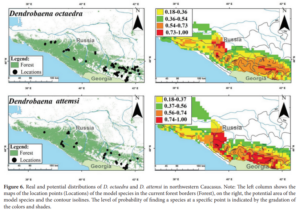
GIS was used to visualize the distribution of both species of earthworm.
GERASKINA, ANNA and SHEVCHENKO, NICOLAI (2019) “Spatial distribution of the epigeic species of earthworms Dendrobaena octaedra and D. attemsi (Oligochaeta: Lumbricidae) in the forest belt of the northwestern Caucasus,” Turkish Journal of Zoology: Vol. 43: No. 5, Article 7. https://doi.org/10.3906/zoo-1902-31
I also found records that utilized GIS to look at wildlife-highway relationships. I remember reading that cicada numbers have drastically decreased due to pavement blocking their way to surface ground, so I found it cool that GIS was mentioned to analyze similar phenomena. The program aimed to reduce animal collisions and work with the land when creating roads. GIS was used specifically to pinpoint critical areas that needed to be changed in order to reach the goal of conservation. (Smith, Harris, Mazzotti, 1999)
Quadruplets. wow. are they all going to the same college? That could be confusing and fun for all.
I think “spatial analysis” and “geographical analysis” are often used interchangeably. Spatial analysis might be thought of as more abstract / mathematical in that it can be applied to things other than geographic space. For example, you can use it to look for cells with certain characteristics on an eyeball, cells that are prone to develop into cataracts. It’s spatial, and a kind of mapping, but not typical geography.
GI Systems are more the technology, applications, etc. GI Science is the research behind all those technologies and applications. So someone who develops spatial analysis concepts is doing GI Science, and someone who uses those tools in software is doing GISystems.
Cool applications.