Hello! My name is Lydia Luna. I am a sophomore Zoology/Environmental Science double major from Mount Vernon Ohio. On our campus, I am involved in Greek Life, Panhellenic Council, Campus Programming Board, and the Admissions Office.
As I read Schuurman Chapter 1, I initially found it very exciting (or as exciting as a book like this can be) that the author of this text is directly aiming to instruct not only technically-skilled individuals but also those (like myself) that may not be overly familiar with this kind of program. I also found it interesting that the author explicitly talked about all of the different roles that GIS can play in society, which furthers the idea that GIS and this text specifically are not only for the people that you would automatically think about. I also really enjoy when someone that is teaching a topic can not only see why their work is important, but also the flaws in it. Reading the author addressing the flaws in these programs makes it seem like when I inevitably get frustrated in the process of learning how to use them, I’m not alone, which is an oddly comforting feeling. The explanation of the two components of GIS was new to me, with there being a “systems” side of things and a “science” side of things. It was very interesting to learn about how GIS can mean different things to different people, even outside of the different core uses. On top of that though, the authors also discuss the overlap in the two, which revolves around the concept of space. Once the space is officially called data, then it goes into the two components, whether to be collected or classified. It shows that while all of this kind of stuff can be very different and can be used for many different purposes, it all comes from the same core data. As a whole, this chapter just made GIS seem much more approachable and useful, no matter what career field I choose to go into.
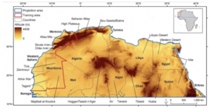
One of the applications of GIS that I looked into was in the realm of conservation, as I am interested in the use of environmental science in the zoology world. In the article I found, GIS was used to observe the changes in the environment in Northern Africa in order to explain the changes in biodiversity there. I also looked into the applications of GIS in water resources, which gave me an article about how the program can be used to model the way that water management would work in different locations before actually installing different methods.

Sources:
- Brito, J.C., Biogeography and conservation of taxa from remote regions: An application of ecological-niche based models and GIS to North-American canids. Biological Conservation 142, 3020-3029 (2009). https://doi.org/10.1016/j.biocon.2009.08.001
- Tsihrintzis, V.A., Hamid, R. & Fuentes, H.R. Use of Geographic Information Systems (GIS) in water resources: A review. Water Resour Manage 10, 251–277 (1996). https://doi.org/10.1007/BF00508896
The chapter does a good job of balancing the more conceptual/academic with technical/systems parts of GIS. Like any technology, there is great value in what it can do, but it is certainly open to all sorts of constructive criticism (from technological limitations to more conceptual limitations). We’ll focus more on the more basic side of concepts and technology in this class, but if you want more sophisticated critical stuff I have plenty.