Chapter 9:
This chapter introduced the Service Area Layer tool, which enables the addition of a network of elements. The section covered various functionalities, including the creation of scatterplots and the use of DemandWeight for calculations. Additionally, the chapter introduced K-means clustering, which is used for grouping similar data points. I enjoyed this chapter, did not have many issues.
Chapter 10
This chapter introduced some new concepts and tools. We also got a chance to use ModelBuilder and build models in ArcGIS Pro. I think this tool could be really helpful if you are creating something. Additionally, the drop shadow under the process and output boxes symbolizing they have been run is cool. The Validate button can also be used to ensure they are ready to run again or edit. I learned that you have to click save before rerunning the model for there to not be error marks by these parameters. I eventually got the model to work.
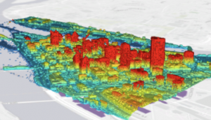
Chapter 11:I really enjoyed learning the keyboard shortcuts for moving around the map in this chapter. By selecting Mapproperties for 3D-> illumination-> date and time, you can see the shadows and 3D features of the map in real time, which I thought was cool. I thought it was cool how we were able to display 3D images on the map like the trees. We also used the Create LAB Dataset tool in 11-4 which made a really cool 3D model of the city. I thought it was cool how we could modify the scale of the building.