1. My name is Sammy Maglott and this is my last semester of senior year. I am majoring in Environmental Science and Zoology. I run Cross Country and Track and am a member of the SEAL house.
- Schuurman Reading: Chp. 1
It’s cool how GIS can be applied outside of the environmental field. I chose to take this class to fulfill my credit to graduate and because I noticed that in many job positions, I was interested in, experience working with GIS mapping was at least desired, if not a requirement. I thought it was really interesting that “spatial analysis” and “mapping” are very different. I was also surprised that spatial analysis allows more information to be obtained than mapping. I’m still a little confused about what information spatial analysis obtains that mapping does not, though. It’s strange to think that GIS is still fairly new as it was first introduced and used in the 1960s. I definitely could understand certain geographers being uninterested in switching from cartography to relying on computer spatial analyses. Growing up in a world where there was already so much technology surrounding us, I think our generation has been more apt to utilize technology. I think it would be difficult to switch from doing something by hand to trying to use a program on a computer. The part about the GIScientist was something that I had never heard of or thought about before. However, I think that it is important that there are people who question the reliability and accuracy of GIS results to ensure that the data we are collecting is correct and usable. It would be sort of a waste to use GIS to analyze lots of data and get a result that isn’t necessarily true or very accurate. I also had never considered how GIS might categorize things, like mountains mentioned in the book, and how these categories or boundaries could become very important when it comes to graphing things like areas in need of federal funding. In conclusion, GIS has a much broader application than I initially thought. Not only can it be beneficial to geographers, but can be used for farming, identifying disease outbreak zones, finding which roads are most likely to flood or degrade, planning electrical grids and gas lines, and much more!
3.Google Applications
Amanda J. Zellmer, Margaret M. Hanes, Sarah M. Hird, Bryan C. Carstens, Deep Phylogeographic Structure and Environmental Differentiation in the Carnivorous Plant Sarracenia alata, Systematic Biology, Volume 61, Issue 5, October 2012, Pages 763–777, https://doi.org/10.1093/sysbio/sys048
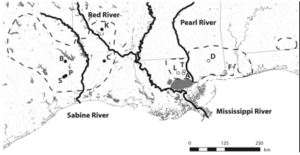
This is a map showing the distribution of different carnivorous plants along with the location of bodies of water in each area. One GIS application used was CIrcuitscape, which allowed them to calculate the total resistance of the landscape separating the pairs of populations. GIS layers are used to find the resistance distance.
Kabatha, P. (2018). An open source web GIS tool for analysis and visualization of elephant GPS telemetry data, alongside environmental and anthropogenic variables. Master Thesis in Geographical Information Science.
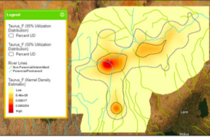
This map shows the distribution of elephants where red areas show higher elephant presence and yellow areas show low elephant presence. GIS applications such as Python, Toolkit, ArcPy, and more were used to generate the map with the different bodies of water and landscapes as well as mark where elephant presence was the highest.