Rose Week 1
- Hello, my name is Evan Rose, a senior from Fairfield, Connecticut. I study Health and Human Kinetics here and I am a part of the lacrosse team. Because of this I enjoy studying exercise and movement along with the food we put into our body. I have used ArcGIS in the past as I was a part of the GEOG 292 class last semester but not the 291.
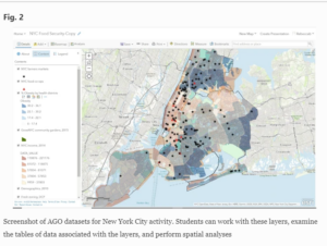
- Because I took GEOG 292 and have some GIS programs, some of this was a review for me. I am well aware how powerful GIS mapping is and how it is used in all facets of our lives. It is used to look at almost an infinite amount of data regarding anything you can think of. Some of the things I did not know was the history behind GIS, especially it being founded and created so early. I figured a program with the amount of strength and use the GIS has probably would have been created later in history rather than in the early 1960s. GIS has an absurd amount of utility and versatility in the modern world as it helps us understand geographical trends. Because of this, GIS has created lots of controversy in the realm of geography as it changes how people perceive maps, data, and geography. People who know GIS and have been using it are thought to be out of touch with the quantitative side and how data is viewed when doing research. I did not realize the philosophical turmoil that GIS has caused since its debut and how it has influenced people’s way of thinking. However, after reading and thinking about it, it does make a lot of sense to me as a program like this with as much power and versatility was bound to shake up the very way people think and look at the field. However, I cannot completely understand the schools of thought and the true extent of influence GIS has had on our world as I am not deeply embedded into the field myself but I can understand that it does have significant impact.
- I find studying food security or lack thereof around the world very interesting and GIS is used a lot in looking at trends in certain areas to help combat food insecurity. GIS helps map out areas of food insecurity and possible geographical reasons that lead to these issues
https://link-springer-com.owu.idm.oclc.org/chapter/10.1007/978-3-030-03273-9_8
- Another thing I looked at was the rates of obesity. GIS was used in a study to mark hot spots and areas that are at risk for childhood obesity in Portugal. From this data they are able to come up with ways to combat this risk and increase the health of others in these areas.
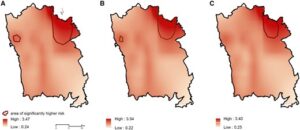
Spatial distribution of the odds ratio of obesity at 7 years of age across Porto Metropolitan Area. (A) Unadjusted model; (B) adjusted for maternal education; (C) adjusted for maternal education and neighborhood socio-economic and built environment characteristics.