Hi, my name is Max Huntington. I am a sophomore transfer student from Massachusetts. I am an environmental science major and I spend like to spend my free time reading or playing video games. I have never used GIS before but I am excited to learn.
This chapter was an interesting introduction to GIS and its history throughout the late 20th century. It is interesting that so many geographers have mixed feelings about GIS, but I suppose it makes sense in context. I was also completely unaware of the insane reach and scale of GIS in the modern world, the many ways in which it has affected my life are crazy to think about. All the different ways GIS can be used makes me glad I am taking this course, as the software is so broadly applicable that it will be helpful regardless of the field I end up going into. I am not entirely sure what the difference between spatial analysis and mapping is, but I gather it is related to the type and amount of information that can be extracted from the process. It is also interesting to see the threads of convergent development in the 50s and 60s across multiple countries and fields arriving at similar software solutions. I hadn’t heard of the concept of “black boxes” in that sense, but it is strange to think about just how many things in our lives operate in this manner. The average person (me included) does not understand the methods by which many things happen, but we accept them as fact nonetheless.
The National Weather Service has a fascinating online GIS portal that can display all sorts of weather and climate related data, from forecasts and advisories, to flood risk assessments and and satellite imagery for the entire country.

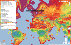
Another interesting application I found was the “Global Wind Atlas” used to determine the efficiency of wind power in various locations by the energy industry. It was created so professionals could determine optimal locations for wind power all over the world.
