Hi, my name is Rheigna (Ray-Na) Gullatte and I am from Cleveland, Ohio. I am double majoring in environmental studies and geography with a sociology minor. I put a picture of Apollo, my cat, because I miss him…a lot. I hope to get an internship in the future that supports my major 🙂 I don’t know much about GIS, but that is why I’m here.

Chp. 1
This was a really interesting read because I am majoring in geography and environmental studies and Dr. Rowley said it would be a very beneficial skill to learn. I’m very obsessed with social justice issues so GIS would only help me in research and mapping things out. Early GIS development happened in the 1960s which is fairly recent but I haven’t heard a whole lot about it. Canada is credited with one of the first cartography systems. I thought spatial analysis was interchangeable with mapping but the article says that spatial analysis generates more information from maps or data. There’s also something called spatial mapping that I looked up. This essentially combines spatial analysis and mapping so that’s cool.
This article was kind of a hard read with all new information being presented to me but there’s many outcomes of GIS. There is GIScience and GISystems which were all created for their own purposes. GISystems includes processes like spatial analysis and encoding into software while GIScience uses theory and justification for the way GISystems work. The way these definitions are worded are kind of tricky so I know I will have to do a little bit extra research and reading to understand. The chapter 2 title piqued my interest because I am taking Human Geography with Toenjes and having classes that help each other flow makes me really happy. It just reassures me that the classes I’m taking are all going to help me in the long run.
My favorite part of the entire article is when it talks about who uses GIS and why. I think it’s interesting how GIS is incorporated into our everyday lives and many people do not realize that. The example they gave to put this into perspective is that GIS is used in the process of where we eat, where our food comes from, and how it gets to the grocery store. Google and Apple maps are very popular GIS systems but a lot of people do not know that.
- GIS keywords- My keywords were “gentrification” and “poverty”

The map above is a simple map showing that gentrification happens at a greater scale in major cities than any other rural city. The major cities where it is happening the most include Washington, D.C., Philadelphia, New York, and San Diego.
The article is called, “Shifting neighborhoods: Gentrification and cultural displacement in American cities”
- This article explains what gentrification is and why it is so problematic. GIS comes into play because it allows us to map out where gentrification is the biggest problem and why. Like stated, gentrification happens the most in major cities. It disproportionately displaces black and hispanic residents. Gentrification is essentially raising property values, tearing old buildings down to build new and modern buildings. Although this may help the economy, it causes cultural displacement for families who are forced to move because the rent is too high.
Richardson, Jason, et al. “Shifting Neighborhoods: Gentrification and Cultural Displacement in
American Cities ” NCRC.” NCRC, 2 Nov. 2022, ncrc.org/gentrification/.
_______________________________
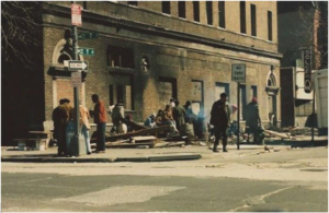

2. I used the same keywords with an additional one, “GIS” “Gentrification” “Washington D.C.”
The pictures above shows the same corner about 40 years apart and you can clearly see how much has changed.
- This article basically discusses one of the biggest cities and their problem with identification. I’m sure a lot of people have been to D.C. but they might write off gentrification as a good thing. I’ve been to D.C. in 2018 and it was running rampant in the hotel where I stayed. A street down from the four star hotel where I stayed would be considered the “hood”. Families’ houses were not up to code, windows broken, and other things that they could not really control. They were watching their neighborhood turn into a tourist attraction.
Person. “Mapping Gentrification in Washington D.C.” ArcGIS StoryMaps, Esri, 16 Oct. 2022,
storymaps.arcgis.com/stories/009773cc5c224421a66d1ce9ff089849.
The stuff you are interested in (in the social realm) has quite a bit of interesting work (using mapping and GIS) and I’m always happy to discuss in more detail. Lots of GIS applications are physical environmental or rather superficial socially, but there are some really neat exceptions.