Hello, my name is Logan Fraire, I am a senior majoring in Zoology and Environmental Science with a Botany minor. I’m pretty involved with the ENVS Department, I am a member of the Student Board as well as the Student Department Manager on the Faculty Board. I really love nature and all the arts (books, fashion, applied, etc.). I’m super into plants and hope to work with them using remote sensing when I graduate 😀
Reading this chapter, it’s interesting to think that people wouldn’t be able to give a single example of GIS impacting their day-to-day lives. It just feels like such a prominent tool in my life that I wouldn’t be able to do a lot of things without it. I did agree that as an undergrad student, I knew what GIS was, but not a ton of how scientists use it for their research. (This text feels like they used big words on purpose to sound cool). When it talked about overlay and spatial analysis, it reminded me of Rowley telling us about how he had to manually overlay maps as an undergrad student. I often forget the times before tech and what that would have looked like so it’s always interesting to me to hear about these methods. I knew of ESRI but for some reason, I didn’t know it stood for Environmental Research Systems Inc. It’s also interesting to think of GIS as a new tool in Geography. It makes sense but to my knowledge, it is nearly fundamental for Geography and would be difficult to do without it. In the context of the chapter, I agree with Nancy Obermeyer’s view of GIS being as fundamental as a calculator. The chapter mentioned how GIS users don’t often question the result output from their technology and I related to this because I am also guilty of not questioning it. I just assume the system is right, like many other users. I agree that GIScience is foundational for GISystems, but it just goes well over my head to keep in mind sometimes. It’s interesting to question the relationship of GIScience/systems with humans. It makes me wonder what the evolving world of AI will do to GIS tech and our relationship with it. I knew about a lot of GIS applications, but not about G-commerce/business applications, very cool.
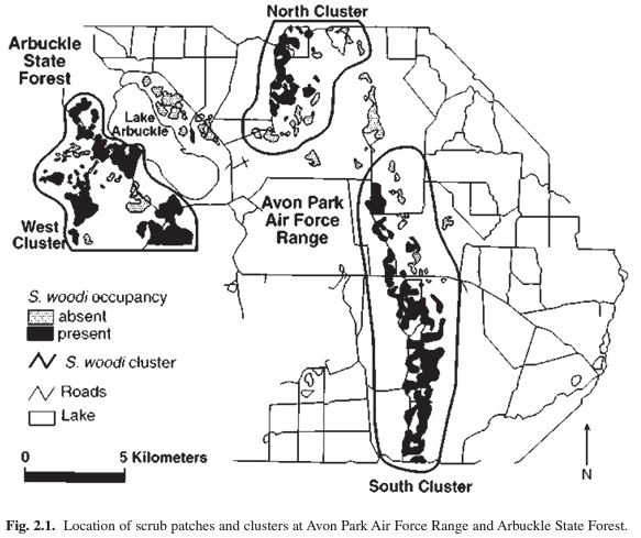
I looked into GIS applications and lizards. I found some cool work using GIS to model lizard habitat sites for research by Branch et al. Here’s a map of those habitat types:
I also found a cool study where they were trying to map the fundamental niche of a nocturnal gecko species using internal, environmental, and climatic data gathered in their work. They used GIS tech to run many models to understand where these geckos might be active in Australia based on multiple factors. Here’s an example of some of those models:
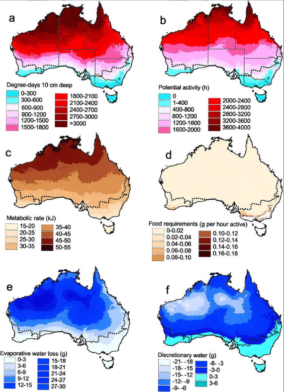
caption: Fig 4: Results of continent-wide 0.05°-resolution biophysical simulations for the physiology of EA6 male Heteronotia binoei for (a) degree-days for egg development, (b) potential activity time, (c) maintenance metabolic costs, (d) food requirements per hour of activity, (e) water loss, and (f) discretionary water. All maps are of annual summations. The dotted line represents the known southern distributional limit of H. binoei”
Branch, L. C., Hokit, D. G., Stith, B. M., Bowen, B. W., & Clark, A. M. (1999). Effects of landscape dynamics on endemic scrub lizards: an assessment with molecular genetics and GIS modeling. Florida Game and Fresh Water Fish Commission.
Kearney, M., & Porter, W. P. (2004). Mapping the fundamental niche: physiology, climate, and the distribution of a nocturnal lizard. Ecology, 85(11), 3119-3131.
Nice, thanks!