Go to the Delaware County Ohio GIS Data Hub and click on All Files. Review the available data (click on each and read the Data Summary): create (in your posting for the week) the name of each data layer and a few sentences about the data:
Zip Code: This file is a dataset with all the zip codes within Delaware County, Ohio. The zip code layer was created in 2005 and is updated as needed through coordinating with the US post office.
Recorded Document: This dataset serves to facilitate the process of locating miscellaneous Delaware County documents by showing the locations of said documents. Examples of documents include vacations, subdivisions, centerline surveys, surveys, annexations, etc.
School district: This dataset shows all of the school districts in Delaware County.
Map sheet: Is a dataset of all the map sheets in Delaware County. Map sheets are a series of map pages where each page shows a specific map extent.
Farm lot: This map shows all the farm lots in Delaware County, as defined by the US Military and the Virginia Military Survey Districts. This data set can be used to identify farm lot locations within the County.
Township: This data set illustrates the 19 different townships which make up Delaware County.
Street centerline: This map shows the center of pavement of public and private roads within Delaware County. This basically shows where all the public and private roads in Delaware County are located.
Annexation: This data set maps annexations and conforming boundaries in DELCo from 1853 to present. It is updated when annexations or conforming occurs.
Condo: This dataset lists/illustrates all condominium polygons that are recorded with the Delaware County Recorder’s office.
Subdivision: This dataset lists/illustrates all subdivisions and condos that are recorded with the Delaware County Recorder’s office.
Survey: This shapefile shows point coverage that represents surveys of land within DELCo. The surveys are found in the Recorder’s office and in the Map Department.
Dedicated ROW: This dataset contains all of the road right of way Polygons in the county.
Tax District: This is the dataset which illustrates all of the tax districts in DELCo.
GPS: This dataset identifies all of the GPS monuments established in Delaware County in 1991 and 1997. The coordinates are in Universal Transverse Mercator Northing and Easting.
Original Township: This dataset illustrates the original Delaware townships before they were changed by tax district changes.
Hydrology: This dataset shows all of the major waterways within DELCo.
Precinct: This dataset illustrates the voting precincts in the county and is maintained by the Delaware County Auditor’s GIS Office.
Parcel: This dataset holds all of the Parcels within Delaware County. They are stored as cadastral geomentries and are maintained by the Auditor’s GIS Office. Changes to the dataset are represented by recorded documents within the Recorder’s Office.
PLSS: This dataset illustrates the Public Land Service System polygons for the county. It was created to help identify all of the PLSS and their boundaries within the US Military and Virginia Military Survey Districts of Delaware County.
Address Point: This dataset is a spatially accurate representation of all the certified addresses within Delaware County and is maintained by the Auditor’s GIS office.
Building outline: This dataset illustrates the building outlines for all structures in Delaware County. The layer was first created from 2008 orthophotos but was updated in 2010 and again in 2018.
Delaware County Contours: This dataset is 2018 two foot contours for Delaware County. It is in File Geodatabase format. I don’t know what they represent but I believe contours can represent continuous things like elevation, temperature, precipitation, pollution, or atmospheric pressure.
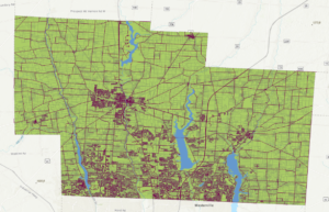
Create a new folder on the external drive you have been using for the GTK ArcGIS Pro tutorial. Call the new folder Delaware GIS Data. Download (to the Delaware GIS Data folder) (as .shp files) these three data sets: Parcel, Street Centerline, and Hydrology (search for this last dataset on the Delaware site if you don’t see it in the list). Create a new ArcGIS Pro project and open these three layers. Create a map that shows all three and save a screenshot and include it in your weekly posting.