Getting To Know ArcGIS by Michael Law and Amy Collins, Chapter 6: Collaborative mapping
Notes and Comments
- The idea that a group of users can work together to gather and record information–also known as crowdsourcing.
Exercise Notes and Screenshots
- An organization is a shared online workplace that is tied to your software license.
- Using domains helps maintain data integrity and does not allow other values to be entered during data collection.
- The data type determines what kind of data that the field can store; the alias can be used to refer to the attribute field by a different name; and the domain determines which existing domain the field can use.
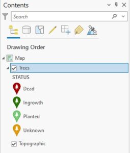
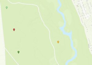
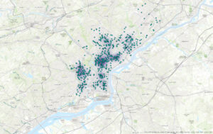
- A tree inventory map allows urban forest managers to identify areas in which tree conditions can be poor and so prioritize maintenance.
Getting To Know ArcGIS by Michael Law and Amy Collins, Chapter 7: Geoenabling your project
Notes and Comments
- You can create features from information that describes or names a location—typically an address—through a process called geocoding.
- An address table—a list of addresses for features that you want to map and that are stored as a database table or a text file.
- Reference data—commonly from a streets layer, on which the addresses can be located.
- An address locator—a file that contains the reference data and various geocoding rules and settings.
- You can use overlay analysis tools to identify and visualize how potential retail site locations may serve customers in the neighborhood.
Exercise Notes and Screenshots
- When you geocode the table of retail locations, you will use the reference data to create an address locator to create point features that represent the locations of the addresses (also known as locator styles).
- When you geocode an address, the address location is interpolated from the range of addresses found on a given segment.
- A locator determines other settings for geocoding, including what comprises a matched address, search parameters, and tolerance for spelling errors.
- Rematch Addresses pane allows you to review which addresses are unmatched or insufficiently matched.
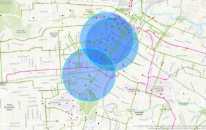
- Buffers are polygons that are created around a feature at specified distances.
- The Clip tool extracts features using other features as a “cookie cutter” or trim boundary.
Getting To Know ArcGIS by Michael Law and Amy Collins, Chapter 8: Analyzing spatial and temporal patterns
Notes and Comments
- Crime mapping analysts can use GIS to identify spatial patterns to gain a better understanding of the role of location, proximity, and opportunity, while providing key decision-makers with information to put crime prevention solutions in place.
- Temporal data is data that has a time attribute.
Exercise Notes and Screenshots
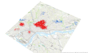
- A kernel density calculates the density of features in an area around those features and is one of the most common techniques in crime mapping.
- The Optimized Hot Spot Analysis tool is used to find statistically significant hot spots and cold spots of robberies.
- Creating a space-time cube can help you aggregate the robbery points, and visualizing it will help you understand how the robbery data is distributed over a geographic area.
- A persistent hot spot is a location that has been statistically significant hot spot for 100 percent of the time-step intervals with no discernible trend indicating an increase or decrease in the intensity of clustering over time.
- An intensifying hot spot is a location that has been a statistically significant hot spot for 90 percent of the time-step intervals.
- A new hot spot is a location that is a statistically significant hot spot for the final time step and has never been a statistically significant hot spot before.
- The Calculate button ensures that the full time extent—start time and end time—is specified.
Getting To Know ArcGIS by Michael Law and Amy Collins, Chapter 9: Defining suitability
Notes and Comments
- A raster is composed of a grid of cells, instead of discrete x,y coordinates, that define geographic entities. The cells contain values that are used to record and define geographic phenomena on the surface of the earth.
- A surface, which is made up of raster cells, can be discrete data, which means that it shows distinct and discernible regions on a map, such as soil types, or it can be continuous data, which means that there are smooth transitions between variations in the range of data.
- Map algebra—a language that combines GIS layers—is fundamental to raster analysis.
- NoData means that no values were recorded for that cell.
Exercise Notes and Screenshots
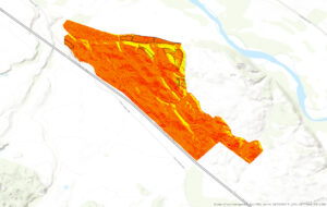
- Aspect is used to determine which direction each part of the ground primarily faces—north, south, east, west, or in between.
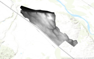
- A hillshade is a surface layer that depicts shadows to model the effect of an illumination source (usually the sun) over the terrain of the land.
- Azimuth is the direction of the sun, expressed in positive degrees from 0 to 360, measured clockwise from north.
- Altitude is the angle of the sun above the horizon.
- No portion of the property is in complete shadow.
- Four of the planting sites contain mostly low-slope (less than 14 percent) topology.
- Two of the potential planting sites include at least some land that faces south, southeast, or southwest.
- None of the potential planting sites are in shadow at 2:00 pm in mid-September.
- The location closest to Paris Valley Rd is a planting site that meets the slope and aspect criteria and also has decent sun exposure at 4:30 pm.
Getting To Know ArcGIS by Michael Law and Amy Collins, Chapter 10: Presenting your project
Notes and Comments
- In a layout, you can arrange common elements, including the map, map labels, a title, legend, scale bar, north arrow, captions, and additional graphics.
- A good map not only provides facts but also persuades opinion. You will want to think about the context of the data and frame the results to match the geographic area of the phenomena.
Exercise Notes and Screenshots
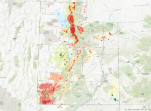
- There are around 18 areas that are fixed wireless technology.
- Labels are based on one or more feature attributes and placed near or on a feature.
- Dynamic labeling is when ArcGIS Pro places labels for all features in a layer with a single click based on predetermined labeling rules.
- When you use the Maplex Label Engine, you have access to a new set of label placement properties that allow you to control how labels are oriented, formatted, and palce in feature-dense areas, and how conflicts between labels can be resolved.
- Label classes are used to specify detailed aspects of how labels are positioned and symbolized.
- A map layout includes map frames and other elements, such as scale, legend, north arrow, and more.
- ArcGIS Pro has rulers, guides, and a grid to help you arrange map elements on a page.
- Map frames are containers for maps in your page layout. They can contain any map in your project, including 3D scenes.
- A legend will help your map readers understand the meaning of your map.
- A scale bar is a dynamic element that provides an indication of the size of features and distances on the map.
- A north arrow is a dynamic element that indicates the orientation of the map.
Excellent as usual. Plowing through. Not clear why you are having fewer issues. I do think some of it is attention to crazy details. But you also are good at the big picture stuff. Cool.