Hi, my name is Jay McConkey. I’m from Cambridge, Ohio and I am a senior and an Environmental Science and Geography major. My academic interests include GIS, remote sensing, mycology, and plants. My other interests include reading books or manga and running. I have recently started a crochet kit, so maybe I’ll develop a new hobby this year. It’s been a while since I’ve taken a GIS class so through the course I will be brushing up on my previous GIS skills while aiming to master new ones as well.
Having experience with ArcMap, I wondered how the author would describe GIS to the unfamiliar. The opening passage surprised me as the reading begins expanding on the uses of GIS and how it is utilized by many people in many ways. I honestly didn’t know that Starbucks credits its success to the use of GIS software, but it doesn’t surprise me given the scope of what can be done using GIS. This makes me ponder other potential uses for GIS, other than the examples Schuurman describes (landscape architecture, surveying, ect.).Furthermore, it is interesting to read about the origins of GIS and how at the early stages the biggest limitation was technology. Given how much computing power has improved in the last couple of decades, it is no surprise to see the scope of GIS advance just as much The origins of GIS are framed just as interestingly. I had no idea just how messy the origins actually are, but I really like Schuurman’s analogy of GIS to a calculator. It makes sense since modern GIS has some many tools and built-in calculations, but you still have to know which calculations to use and when. The fact that these techniques are more accessible, broadens their potential application.
One aspect of GIS that is brought up is the power of imagery. Schuurman states that GIS commonly refers to ‘geographical information science’ as well as ‘geographical information systems.’ I feel like, at this point, GIS is so complicated and involved in so many sciences that it is impossible to fully define in a single sentence. Schuurman elaborates on this later in the readings when she states that GIScience is used to provide justification for GISystem functions. Schurrman also talks about how GIS digitizes physical data which is therefore manipulated in a way that the user interprets the world. This reminds me a great deal of one of my first GIS assignments given by Dr. Rowley. He had us use remote sensing to classify a GIS satellite footprint as disturbed and undisturbed land. We all classified our maps slightly differently according to our own personal biases. This made each of our maps slightly, or wildly different and showed us how GIS data is interpretable. Furthermore, emphasis is placed on the importance of visuality and how humans use visuals to comprehend concepts or statistics. The subject of colors, textures, and symbols in map-making is fascinating to me and is something I would like to learn more about. Another interesting inclusion that Schuurman describes as an interest of GIS users is whether GIScience is inherently gendered. This fascinates me, because I do not fully understand how a geographical system could be gendered, but I have a feeling it stems from past geographers who are mostly male.
GIS Applications:
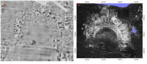
The first GIS application I looked into was ground penetrating radar, which is used for archeological studies. The source I found described a new processing tool, which automates certain processes and identifies anomalies. With the ground penetrating radar and GIS, the team was able to analyze buried structures. The image below is an Ancient Roman theatre that is currently underground.
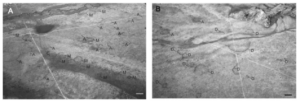
 One of my academic interests is mycology, so I looked up related GIS applications with fungi and found a study using GIS to assess the distribution of fairy rings. Overall I found the study interesting and I hope to come across more research that uses GIS to study fungi. The picture below was taken from an airplane and includes the fairy rings are identified.

file:///Users/jaymcconkey/Downloads/remotesensing-14-03459-v2.pd
https://www.sciencedirect.com/science/article/pii/S1754504821000027
The “gendered” does in part have to do with a male-dominated career area, but also a much m more complex set of issues: https://sites.owu.edu/geog-112/dmt-iii-feminist-data-visualization/ (from Geog 112).
My kid does so much crochet that it’s driving us crazy. She did win some art prizes with some of her work, however. Scroll down to the crochet face: https://sites.owu.edu/akowu/2022/10/25/art/