Hello,
 My name is Evelyn VanderVelde, I am a senior majoring in Environmental Science with a minor in Botany. I hail from Holland, Michigan, and part of Zeeland, Michigan as well (duel households for the win).
In Chapter 1: “GIS a short introduction” by Schuurman, GIS is defined in many ways, primarily by what its intended use purpose entails. The research that uses GIS morphs the format to each individual user, so a city planner uses GIS much differently than a biological researcher. “It is not a piece of software, but a scientific approach to a problem.” The question of how to best use GIS is based on the question of “where” the data is and “how to encode” the data. GIS is also inherently visual in its applications which creates the importance of color and symbology within this new mapping field. “Visualization is used to manufacture meaning from data, through rendering it in image form. GIS incorporates ongoing research into geographic visualization but, more to the point, it is based on the very principles that have recently brought scientific visualization to the fore” (Schuurman, 8) It’s also stated that people reason much better with visuals than with other types of data that is more numerical or literary. I found this interesting as previously in my other GIS class we always focused on having visually enticing and simplistic in its interpretation for all types of viewers, but I don’t think any definition like this was brought up. It makes a lot more sense to me as to why the visual components of my maps on GIS were so heavily stressed previously. The blurred boundary between definitions of GIS is confusing for me as well as there is no set criteria for which I should create my maps. This conflict though could be helpful as it gives more liberty artistically.
- Geomorphologist: studies how the earth’s surface is formed and changed by rivers, mountains, oceans, air, and ice. The study of the land around us.
- ESRI = Environmental Research Systems Inc.
GIS Applications:
Source: https://developers.arcgis.com/python/samples/detecting-swimming-pools-using-satellite-image-and-deep-learning/
Source for python:https://pythonapi.playground.esri.com/portal/home/item.html?id=2f8f066d526e48afa9a942c675926785
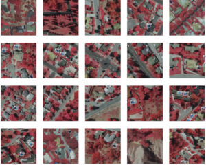
For this link, I looked up swimming pool detection and found this link via the ArcGIS developers themselves. I was given the coding to add swimming pool detection to my maps and the infrared needs in order to be able to label uncovered pools in residential areas. The image to the left shows multiple images that were used to train the ArcGIS system in finding swimming pools in residential areas.
swimming pool gis.
actually used to track water usage issues.
cool.