
Hi! My name is Ben Buroker and I am a junior at OWU. I am an environmental studies and geography double major with a minor in Spanish. I love being outside hiking, surfing, running, swimming, and skiing and am on the lacrosse team.
The first thing that strikes me about the PDF was the multifaceted applications of GIS. I hadn’t made the very obvious connection that the police or car navigation systems would be using GIS. I am slightly confused about the section in the beginning of the reading where they talk about who the reading is made for. The use of the phrase “catholic encompassing interested physical and social geographer” is throwing me off because I don’t see how this connects to the framing of this reading. It also strikes me how important and useful GIS is for state/local governments or municipalities. I thought that the explanation of how ‘layers’ first started was really interesting. I actually feel like it makes me understand the layers that I’ve put into GIS more than before. I don’t even want to think about the level of intelligence and thought and design that went into developing a GIS system. The section about ESRI solidified for me how beyond my scope of interest the computer science side of GIS is. I appreciated the section on visualization and the amount of importance they give to visualization when working with GIS. In my experience, being able to properly convey information through your maps is the most important piece of the puzzle. It doesn’t matter how well you know the program, or how fancy you can make your map, if people don’t understand it or are unable to contextualize or get any meaning from it. The field of GIScience is interesting to me. Are we in this class doing GIScience? When, if ever, is working with GIS not GIScience? I am interested in the section on B2B and B2C portals and the role of GIS in them. I’ve never heard of GIS’s effect on businesses in this manner and would be interested to know what GIS specifically allows businesses to do nowadays versus 100 years ago. I’m almost positive the power of GIS and what businesses have access to is intimidating.
I read an article about the myriad effects that GIS can have on agriculture, specifically about agricultural and natural resource management. Things that GIS and remote sensing (drones) can help with are crop inventory, crop yield analysis, nutrient and water stress, and land use and land cover.
Source: Marshet Nigatu Gebeyehu, 2019. “Remote Sensing and GIS Application in Agriculture and Natural Resource Management,” International Journal of Environmental Sciences & Natural Resources, Juniper Publishers Inc., vol. 19(2), pages 45-49, May.
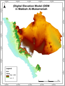
My second article is about applying GIS for solar power plant site selection in Makkah, Saudi Arabia. The article discusses the current demand for electricity in Saudi Arabia and the unique geography that allows solar to be such a worthwhile investment and option for this specific area. It also discusses how GIS was used to generate a number of maps that were relevant to the study. They were looking at different locations to build test sites, and needed to know about ground elevation, the roads, and the electric grid in the surrounding area.
Source: https://www.scirp.org/journal/paperinformation.aspx?paperid=115795
soil, eh? good you are going to be here next year for Toshi.
“catholic encompassing interested physical and social geographer”
Ok, that gets into a long story. This chapter is out of a book. The author is situating herself. “catholic” (lower case, means pragmatic, or encompassing a wide range of things). Physical and social refers to geography. She does both more quantitative physical geography and more qualitative human geography. There are lots of debates within Geography and GIS about GIS leaning strongly towards quantitative, physical geography. Critiques from more qualitative approaches that it limits as well as expands understanding. I have stuff to read if you want more on this!