Hello, my name is Cailee Plunkett and I am a junior Environmental Science major from Cincinnati, Ohio. I am also a transfer student, so this is actually my first semester here at Ohio Wesleyan. I am very excited for these next two years and can’t wait to become more involved on campus. I love to hike and do anything that gets me outside, I love animals, and I am a runner.
Chapter 1:
What I found interesting about this chapter was just how many different uses GIS has, and how many people in different jobs and fields use it. For example, it can be used for farming and municipal management, but GIS can also be used to map complex networks that provide power, fuel, and water to a town or city. Waste collection routes are mapped using GIS. Even Starbucks has reportedly used GIS. I also thought it was interesting how the acronym “GIS” can be split into GISystems and GIScience, and that GIScience is almost the theory that underlies GISystems.
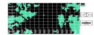
The Application of Remote Sensing and Geographic Information System (GIS) for Monitoring Deforestation in South-West Nigeria
In this article, GIS was used to detect deforestation in Southwest Nigeria between 1978 and 1995 and detect land use and land cover change in Southwest Nigeria as well as to assess the stability of the land. The results of the study show that in 1978, forest vegetation covered 88.25% of the surveyed area, and that this had decreased to 63.13% by 1995. With forest cover change, between 1990 to 2000, Nigeria had lost an average of 409,700 hectares of forest per year.
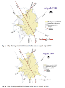
Urban Sprawl Development Around Aligarh City: A Study Aided by Satellite Remote Sensing and GIS
In this article, GIS was used to rapidly assess the developments of sprawl in Aligarh City. The results of this study show that the urban area of this city has increased around three times since 1971, and that around 1990, there was a sharp increase in land consumption as compared to population growth. As the city does not have a sewage treatment plant, with a growing urban area, there is less area for the water to drain into soils, and there will also be more flooding in low lying areas. By studying and watching for urban sprawl in an area over time, residential development can be better monitored.
References:
Peter, Yohanna, Innocent Reuben, and Emmanuel Bulus. “The application of remote sensing and geographic information system (GIS) for monitoring deforestation in south-west Nigeria.” Journal of Environmental Issues and Agriculture in Developing Countries Vol 4.1 (2012): 6.
Farooq, S., and S. Ahmad. “Urban sprawl development around Aligarh city: a study aided by satellite remote sensing and GIS.” Journal of the Indian Society of Remote Sensing 36.1 (2008): 77-88.
hey: good first post but do try and catch up (and/or talk to me). I’m also behind on reviewing work in the class, sorry about that.