Author Archives: jbkrygier

Delaware Run Storm Drain Net Project – News, Photos, Videos

OWU and City of Delaware Storm Drain Net Collaboration (OWU E&S Blog, Feb. 1, 2019)

Students and faculty have been working a project to implement a storm drain net in the Delaware Run on campus. The purpose of the net will be to remove trash and green waste/debris from the Delaware Run behind Merrick on campus.

Net Placed in Delaware Run; City, OWU Seek to Improve Waterway (Delaware Gazette, Sept. 10, 2019)

Ohio Wesleyan University, Delaware partner on student’s stream study project (This Week Community News, Sept. 13, 2019)

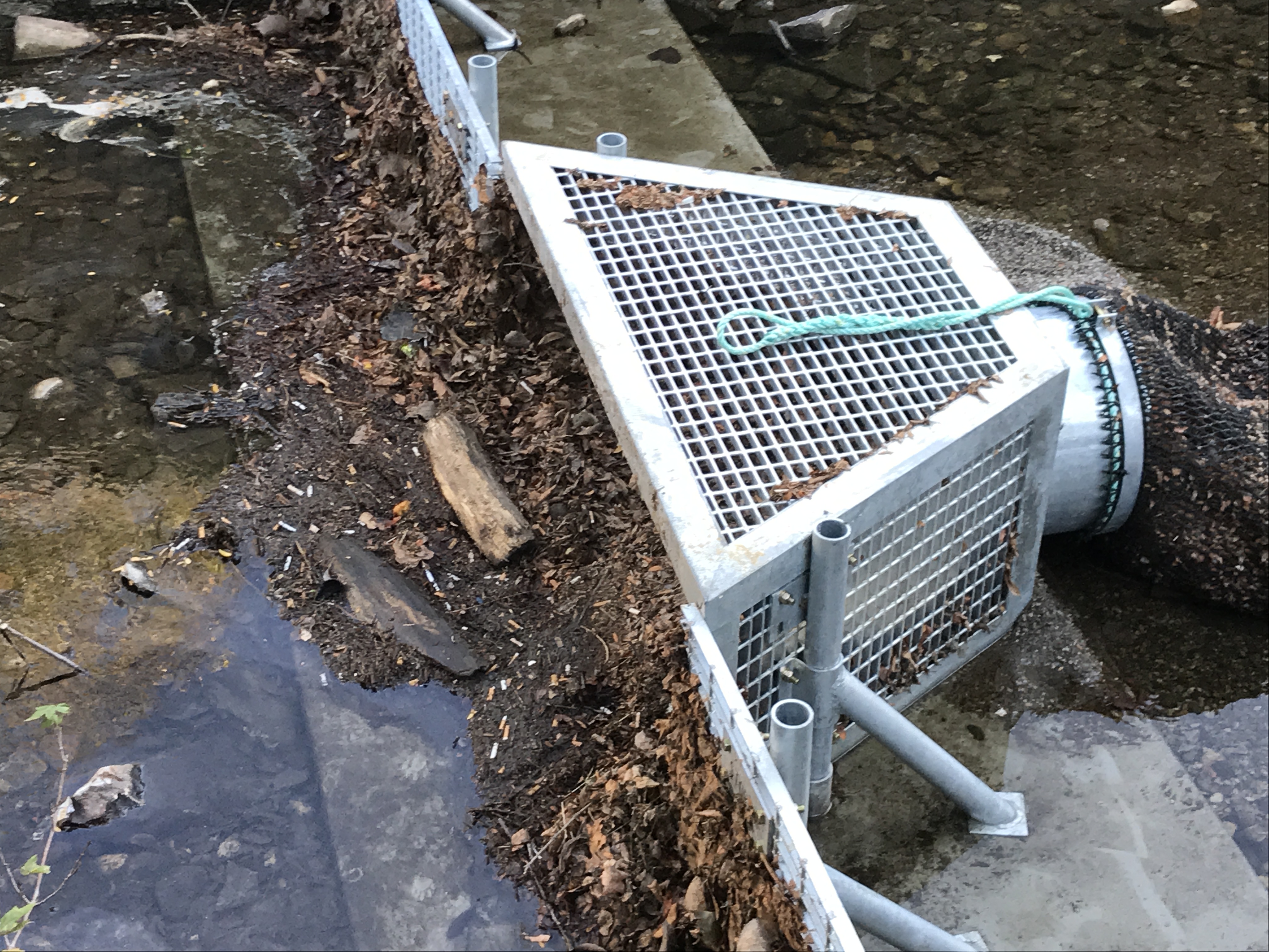
Delaware Run Storm Drain Net Installed and Catching Crap! (OWU E&S Blog, Sept. 25, 2019)

Update after the net was installed in early September 2019. Includes video.

Environmental Impact: Ohio Wesleyan Student Earns Litter Prevention Award for Storm Drain Net (OWU Press Release, December 6, 2019)

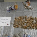
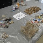
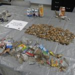
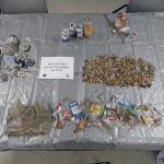
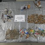
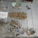
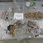
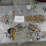
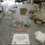
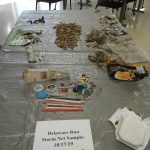
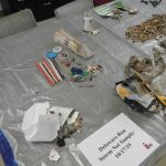
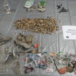
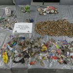
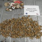
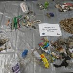
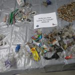
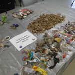
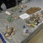
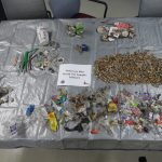
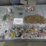
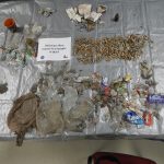
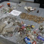
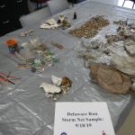
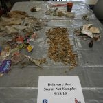
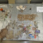
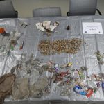
Fall 2019 Debris Gallery: Below is a gallery of sorted debris collected in September and October of 2019. The net is unloaded and allowed to dry (for weighing the organic and non-organic material) then sorted. The organic material is returned to Delaware Run. There have been almost no fish or insects or other lifeforms in the debris collections.

About

Use the tabs above for additional information on the Delaware Run and its potential restoration.

The restoration of Delaware Run adjacent to Ohio Wesleyan’s campus has been investigated over the past five years. The Run was channelized more than a century ago, and the channel walls are old and in poor shape. Delaware Run, in general, is facing growing problems with flooding (due to upstream development with, apparently, inadequate controls on run-off), contamination with lawn chemicals and agricultural runoff, and contamination with e. Coli.

Presentation on Delaware Run: Updated Spring 2020

The general idea of restoring this stretch of Delaware Run is to provide a means of capturing some of the growing quantity of water while filtering contaminants in the water before they reach the adjacent Olentangy River.

Ideally, this stretch of Delaware Run could be tied to restoration options further upstream. Ideally, the area of Delaware Run along campus could become an outdoor lab, for University and K-12 projects, focused on riparian and water issues. Thus this project would serve both environmental and educational purposes.

Ultimately, this regional approach to the Delaware Run is similar to what are being called Sponge Cities: urban waterway redesign to cope with climate change, water, and water quality.

Delaware Run Flooding April 3, 2017

Dr. Amador Rowley (Geography) looking quite concerned about Delaware Run flooding along the north side of OWU’s campus. There is not typically a lake (with ducks) in this location. The channelized stream bed can be seen in the background, in front of the stone wall.

Below find an image of the Delaware Run as it emerges from under (!) downtown. The water level is about 2′ t0 3′ above normal. Notice the stone walls on the left beginning to erode away.

Continued development upstream, with inadequate stormwater retention, has led Delaware Run to flood at an increasing rate. Restoration of wetlands and other remediation efforts are part of the Delaware Run master plan, currently under development.

Blog Postings, Student Project, Spring 2014

Blog postings by Date with Topic: Spring 2014 Student Project (postings below)

W 2 17: Proposal Draft
S 2 19: Terminology
M 3 24 / W 3 26: Field Work
M 3 31 / W 4 2: Field Work
M 4 7: Beginning Issues
M 4 7 / W 4 9: Field Work
M 4 12: Field Work and Lab work|
W 4 14: Final Day of Tree Fieldwork
M 4 21 W 4 23: Lab Day and Fieldwork
W 4 23: Final Maps with all trees and soil sites
M 4 28: Final Map Drafts

S 5 4: Additional Information Gathered

Tree Information
Wall Observation
Restoration and Clean up
Historical Site
Soil Samples

M 5 5: Final Project

PDF
PAGE

March 31 – April 2: Field Work

The past week and a half we have been mapping out the location of each tree on the floodplain including various estimates on; the circumference and height of the trees, whether they are native species or not, if they are included in the arboretum  and the tree type. We used the pencil method to find the estimated height and measured the circumference with a measuring tap from the geology department.

This data has never been collected before and will be very important as we try to predict a path for the delaware run. We are currently placing our data in arcGIS in order to create a map with our individual attributes.

Initial Project Issues

Issues that we are going to have to deal with.

  • The route of the run

    • How it will affect the trees

    • How much we will be able to change the path (How much will the contractor do)

    • Is there anything we have to work around for the path( utilities etc..)

  • Coordination of different groups

    • Who is involved with this project (Names and contact information)

    • Do we all have the same view on the project (on  the same page)

Terminology

Research on Stormwater Credits:

Delaware:

http://www.delawareohio.net/UserUploads/UserDocuments/

Departments/Public_Utilities/StormCreditManual.pdf


Ohio:

http://www.neorsd.org/I_Library.php?a=download_file&LIBRARY_RECORD_ID=4699


Storm drain decals in delaware run? – on drains above the bridge

Floodplain zones:

1. 0.2 PCT annual chance flood hazards (special flood hazard areas)

2. A: area subject to a 1% or greater annual chance of flooding any given year, with no flood elevation shown

3. AE: area subject to a 1% or greater annual chance of flooding any given year, with extensive hydraulic analysis that shows the flood elevations

4. X: areas of limited flood hazard (outside 0.2% annual chance floodplain)

Information on soil type: In order to prove we cannot build buildings on this floodplain it is important to look at what soil types exist in order to prove it is a wetland.

Sloan silt loam, 0 to 2% slopes, occasionally flooded:  Very deep and poorly drained soils formed in loamy loose unconsolidated sediment. Sloan soils are most commonly on flood plains and are very poorly drained due to low permeability.Known to be artificially drained and cultivated but also known to be used as pastures or woodlands.

silt (size measurement between sand and clay whose mineral composition is quartz and feldspar. May be a soil or a suspended sediment).                                                                                                                            loam (soil composed mostly of sand and silt, with a little clay).

Scioto silt loam, 0 to 2 % slopes: contains very deep poorly drained soils and are subjected to flooding from late fall to spring. Known to be artificially drained and cultivated but also known to be used as pastures or woodlands.cropped delrunsoilclip

Sources:

https://soilseries.sc.egov.usda.gov/OSD_Docs/S/SLOAN.html

https://soilseries.sc.egov.usda.gov/OSD_Docs/S/SLOAN.html

Proposal Draft

Proposal:  Collaborators: Smith, Kerns, Siefker, Taylor

Rough Proposal. 2.3.14

 I. Review data from previous restoration project. Our group has discussed the validity of using and building on previous project, and collaborators to keep this momentum moving in a continuous pace.

 II. Visually assessing the  property to get a better understanding of the project and its implication. This will better our understanding of the work that has been completed and what needs to be prioritized.

Issues that we are going to have to deal with.

  • The route of the run

  • How it will affect the trees

  • How much we will be able to change the path (How much will the contractor do)

  • Is there anything we have to work around for the path( utilities etc..)

  • Coordination of different groups

  • Who is involved with this project (Names and contact information)… Kristin Piper (City of Delaware watershed coordinator), Peter Schantz (OWU’s Head of Buildings and Grounds)—> obstacle due to Eliot Hall which is their main focus right now.

  • Do we all have the same view on the project (on  the same page)

 III. Create an OWU wordpress blog site.

IV. Developing a better understanding of our project jargon. Research differences in EPA  restrictions for stormwater credits.

research on storm water credits—>

Ohio: http://www.neorsd.org/I_Library.php?a=download_file&LIBRARY_RECORD_ID=4699

Delaware:http://www.delawareohio.net/UserUploads/UserDocuments/Departments/Public_Utilities/StormCreditManual.pdf

V. Get a drone scan and layout of the area in question. Get better understanding of existing vegetation to find what bio-obstacles are in the path of restoration. (Email Prof. Blanks to get approval)

VI. With all information received start a preliminary mapping of the suggested stream reconstruction.

VII. Meet with city legislation to see if our projected plan has possibility, or needs revision.

Project Start

image-61

Today is the first day for our humble blog. We as a group will be adding historic archive information and create a platform to build our project.

The previous Delaware Run project blog is here: Delaware Run Project (2013)

[pertinent information has been moved to this blog]