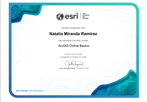
Note: I completed the quiz, and I completed the other work in GEOG 291.
Introduction: Hello! I am Natalia Miranda Ramirez, and I am a sophomore at OWU. I am from Columbus Ohio and a commuter student. I am also an Environmental Studies and International studies double major. Currently, I am thinking of pursuing a career in environmental law, but that could still change. Outside of class, I have a part time job which means I am either working or doing school work. I also hope that GEOG 292 will help me get a better understanding of GIS software. I had some technological difficulties in GEOG 291, but I hope to do better in this course.
Comments on Exploring ESRI Account: I like that there are a lot of resources and that I have access to my personal information which I can edit. Plus, there are a lot of collaborations among different areas of study which makes it possible to connect with others. Additionally, I know there is a lot of stuff regarding GIS that can get confusing, but thankfully the training page simplifies all the categories and facilitates learning. I also appreciate that there are free courses that teach the fundamentals and basics of GIS. Furthermore, I appreciate that there is a large variety of stories from different fields that one could use for personal reference when it comes to research.
Examples of GIS in Research:
- I found this short research paper that compares federal regulations and Indigenous regulations for endangered species in the U.S. This study used GIS mapping to keep track of certain species such as the Black footed Ferret and the Mojave Desert Tortoise. There is some overlap among both regulations when it comes to certain species. Additionally, there also seems to be a notable pattern, where a lot of these ranges are larger on the west side of the country than the east side. This study is important for comparing land regulations for animals and its main conclusion is to emphasize the importance of land management in the country.
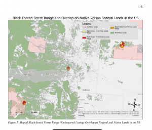
Source: https://api.mountainscholar.org/server/api/core/bitstreams/88b1174b-4fd7-405e-86e1-395a4d69c7e5/content
- The second example of GIS in research I found was about sustainability development in Norway. In the study, the researchers specifically looked at environmental factors influenced by climate change such as air quality and how to improve it. The study elaborates on the layers, data and specific GIS web that they used to create multiple maps regarding their research. Additionally, this study also analyzed the geography of the country and where and why some places are more polluted than others. It takes into account natural vegetation and anthropogenic factors such as car pollution. Overall this GIS study is helpful when it comes to studying and finding solutions for improving air quality in Norway.
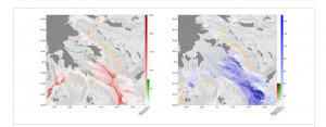
Source: https://onlinelibrary.wiley.com/doi/full/10.1002/sd.2787
Comments on ESRI Reading: I like that I can private my maps, especially if it is something I am continuously working on. That way I don’t confuse the public or even community members who want to see my GIS study. I also like that there are tutorials that explain how to use the GIS software. I believe that there are also some video tutorials that can visually demonstrate how to do a certain feature. I really like those step-by-step guides and I believe that they will be helpful.
Comments on Training: I learned about the ArcGIS Apps and external websites that can be helpful to expand one’s current GIS content. I also liked how they demonstrated how to turn a 2D map into a 3D map. Throughout the training, I noticed that there are a lot of terms that are similar, when it comes to using the GIS software. I remember that some of these functions and terms were confusing for me in GEOG 291, especially at the beginning of the course. Thankfully I learned throughout the course but, nonetheless, I really appreciate the definitions of the functions, maps, and layers.