Introduction: My name is Ava Johnson and I am a senior! My major is East Asian studies and I have recently come back to the U.S. after being in Japan for the second time since I have been in college (once to study abroad, and the most recent time for a TPG). I actually took GIS 292 in the fall of 2024, but I truly do not remember most of the things that I learned since it’s been a year and a half. I am excited however to get back into the swing of things for my last semester here at OWU!
Chapter 1: As someone who has mistakenly already taken GIS 292, this chapter was a very nice refresher to be able to go over the ropes again as it has been nearly 2 years since I have done anything remotely related to GIS. Nadine Schuurman introduces Geographic Information Systems, or GIS, by showcasing the many ways that GIS has been used, and can be used in order to peak a person’s interests. In other words, explaining there is no singular way to utilize GIS, and uses examples of college students, epidemiologists, and even corporations like Starbucks utilizing it all in different ways. She argues that GIS can be understood simultaneously as a tool, a science, and a socially embedded practice, and that debates over its identity reveal deeper tensions about knowledge, power, and representation. I appreciated how Schuurman explained GIS first as a technical system designed to capture, store, analyze, and visualize spatial data to then lead to how it has transformed over time. This instrumental view highlights GIS as software and hardware used for mapping and spatial analysis. However, she also makes note to mention that there are in fact many limitations of this definition, noting that it ignores the theoretical assumptions built into GIS models, such as the simplification of complex social realities into discrete data layers. I also really appreciated how Schuurman introduced critical perspectives that view GIS as socially constructed and politically charged, not solely biased towards positive outcomes of utilizing GIS. This section really takes a step back from the exciting possibilities that come with using GIS to showcase realistic concerns and how these thoughts can oftentimes challenge the assumption that GIS is neutral or objective. With that being said, Schuurman’s chapter encourages readers to see GIS as more than a technical tool. This chapter shows us as readers, and relatively new or unfamiliar with the tool, how GIS shapes knowledge, whose interests it can peak, and how it might be used depending on what a user needs it for.
Application 1:Since I studied abroad in Japan, I thought it would be cool to find something related, and I did! I found this application of the different borders of Japan, specifically different prefectures. Along with this, specific kinds of data such as area in square kilometers, as well as population rates were also on the map once a specific prefecture was selected.
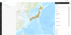
Source: Michael Bauer Research GmbH
Application 2: Similar to the first application, I searched up “recent earthquakes near Japan”, and an application came up with different hotspots, deaths, injuries, and overall popular locations.
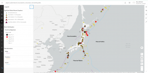
Source: Maria da Conceição Neves