Yes, I did take the quiz.
I go by Gustav but my boring name is Samuel. I am an english major who is taking this class as an upper level Gen Ed.
I found the chapter to be very interesting. When I was given the introduction to this class I had ben informed of the multi-disciplinary applications this knowledge could have but reading the chapter really put things into perspective for me, as the chapter seemingly had a way to trace nearly every sector of out lives back to GIS applications. I especially found the passages regarding the applications for precision farming and for utility companies to be particularly interesting given that I feel those are sectors of life that most people don’t give much of a second glance at in day to day life and it is very enlightening to see just how much work goes into these fields using GIS alone all for the common man to simply ignore them on the basis of “out of sight, out of mind”.
I think my biggest takeaway fro the chapter was the knowledge on the subject of GIS itself. My first impressions as someone who had never seen that acronym before was that was the name of a commonly used computer program sed to conduct geographical analysis in a similar way to how business students are taught to use Microsoft Excel or how Engineering students are taught with Autodesk Inventor. Upon reading more (and coming across the interesting history of GIS dating back to the 19th century which I found to be absolutely fascinating) I found out that my initial assumption was quite wrong and that GIS is much more of a scientific field in itself given the vast ways geographical data could be gathered and interpreted.
The main application I am curious about is Geographical Criminal Profiling. I have a minor interest in criminology (though I have received no formal education on the matter) and GCP is very commonly used in many criminal investigations.
Source: https://atlas.co/gis-use-cases/geographic-profiling/
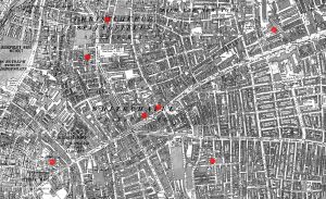
Something I think would be interesting to do in this class is using the GIS software I could create a geographical profile of the infamous Jack the Ripper murders in the autumn of 1888. I find most maps on the subject (below) tend to be rather unenlightening and not particularly interesting for nerds like me as they tend to include many non-canonical events in their analysis (The map I have included in this post from Wikimedia commons is one of the worst offenders in my opinion) and I personally would like to see one based much more in the facts rather then the insane amount of theories.