Introduction: Hello, my name is Reghan Gist! I am a freshman from Delaware, Ohio and am planning on double majoring in Environmental Science and Zoology. With this degree I would love to do some sort of fieldwork with animals, I love animals and have 4 pets back home! I am also a part of the cross country and track team here at OWU. I am new to GIS, but I am very excited to learn what I can create and do with the software.

Chapter Reflection: The first thing that caught my attention reading this was the explanation of how GIS has experienced a boom of popularity and is used in a variety of different fields. When learning about this class I did not realize how many other non geography related career paths, including Starbucks, would also use this technology. I assumed GIS was used solely for graphing environment related data, which is very wrong after reading. I found it very refreshing to hear that the software is considered confusing because of how different people see it differently. I enjoyed reading about how each person can utilize GIS in a way that best fits their needs and interests. This chapter provided so many examples of what GIS has or could be used for and shows that the opportunities are endless, which can explain why so many are drawn to the technology. I especially was interested in how GIS is affecting our lives even if we do not notice it. Oftentimes I, and presumably others, want something to have a clear and correct identity, however because this chapter provided lots of examples of uses this helped me understand it better. I especially liked the part of the chapter where it explains how GIS impacts society through shaping decisions that affect our lives. Of these impacts, the one that interested me the most was how GIS created crime maps that were able to stigmatize neighborhoods and hazard maps that pointed environmental pollution to be mainly in low-income communities. Overall, through Schuurman’s emphasis on GIS being more than just a software tool and having much larger impacts, I was able to gain a better understanding, learn examples of where it is found in everyday life, and be much more interested in the class and having the opportunity to gain my own experience working with GIS.
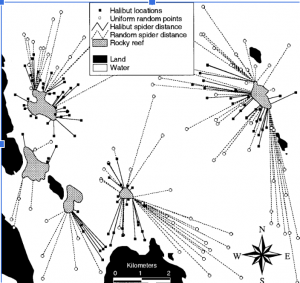
GIS Applications (1): Marine Life: One of my interests within the environmental science field is marine life and oceans. I was curious how GIS could be used to gather information on specific marine species and their habitats. Through this search I found an article titled “Using GIS to Analyze Animal Movements in the Marine Environment” (https://www.researchgate.net/profile/Jerald-Ault/publication/249994071_Spatial_modeling_of_fish_habitat_in_Florida/links/00b7d51e967547ab22000000/Spatial-modeling-of-fish-habitat-in-Florida.pdf#page=47) This article provided lots of useful information and graphs on spatial processes and management of marine populations. Specifically, it focused on tracking certain marine animals. The graph inserted below was one of the specific trackings done in this article that focused on the Halibut, a very odd looking fish I had never heard about. It was done in Glacier Bay, Alaska and found a significant amount of the Halibut locations were close to the Rocky reef compared to being in random locations.
GIS Applications (2): Wildfires: Due to my sister being in California during one of the widespread wildfires, I was very interested in how GIS could or has been used to track these wildfires and provide the graphs and information that we watched on the news while she was there. I found this article (https://www.proquest.com/docview/2179993356?pq-origsite=gscholar&fromopenview=true&sourcetype=Dissertations%20&%20Theses) that focused specifically on tracking wildfires in Santa Barbara that pose threats to the citizens in the area. The student created a web map using local data that allows residents to monitor the evacuation potential, fire size, and emergency updates. This provided a resource to the public to ensure they have access to live information regarding current and past wildfires. There were no graphs provided with the article, however I found it to be extremely interesting and a great way to utilize GIS that could help protect local residents.
I completed the GEOG 291 quiz!