My name is Lily Ogrodowski, and I am a first-year student from Toledo, Ohio. I’m planning on an environmental major (not sure which one yet!), but I’m also pursuing studies in Chemistry. I may also pick up Sociology/Anthropology, or even Public Health. I have a particular interest in the study of freshwater and lakes/limnology, as well as human geography issues like populations, land use, and urban planning.

Schurmann Ch. 1
In my first week of this class, I completed the introductory quiz which reinforced directives on the syllabus. Then, I read Schurmann Chapter 1, Introducing the Identities of GIS. This introductory chapter has given me a solid introduction to GIS and its uses, history, and impacts. I’ve learned that GIS is more than just digital maps—it emphasizes spatial analysis techniques. While mapping “shows” land features, it seems like applying spatial analysis takes that data and “tells” about patterns the data may reveal. With GIS, spatial analysis can be done while combining many different data sets and maps, proving that GIS is ultimately an interdisciplinary tool with uses that extend far beyond geography alone.
A main focus of the chapter is the comparing and contrasting of the two definitions of GIS: Geographic Information Systems and Geographic Information Science. The author defines GISystems as the mapping and analysis methods coded into GIS programs, while GIScience is the research and theory going on behind the scenes. GISystems are generally accepted and used, while GIScience is the ongoing research and theory development that asks questions about these systems and how they apply in different areas. GISystems are the tools, while GIScience involves taking the tools and tinkering with them.
Additionally, GIScience is most impactful when specific local knowledge is taken into consideration. In the chapter’s example of public wells being linked to cholera cases, a specific understanding of the location of focus inspires a most efficient use of GISystems, thanks to GIScience. However, because GISystems are formulated by people, that means they will inevitably have bias or limited perspectives. The chapter concludes by describing a main goal of future GIS development as involving the integration of multiple ontologies, or conceptual systems of thinking and organization within GIS.
Before reading this chapter, I don’t think I realized how prevalent GIS is in the development of our world. It makes sense that GIS models would be used in agriculture, transportation, energy, and housing, but I did not realize the extent to which GIS plans with efficiency and optimization in mind.
GIS Applications
The first GIS application I found was the Food Environment Atlas from the United States Department of Agriculture (USDA) Economic Research Services. I clicked on the Grocery data set, which shows the number of grocery stores in each county. (The darker the shade of pink means more grocery stores.) I found lots of large zones with few grocery stores or no data in the Appalachia region of Kentucky and West Virginia. (I outlined them with my computer’s Draw tool.)
I know from research in other classes that these regions face very low income rates, and they are home to food deserts, or places with inadequate access to healthy food.
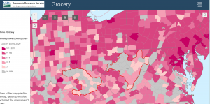
Grocery | Food Environment Atlas
Next, I found an application from the National Centers for Coastal Ocean Science (NCOOS) that forecasts harmful algal blooms in Lake Erie. I went into the archived videos to find a date with high levels of algal blooms and settled on July 25, 2023. This application is a good example of how overlaying different data sets, like cyanobacterial density and wind patterns, is what makes GIS helpful when explaining the reasons for the trends we see.
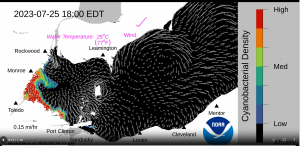
Bloom Position Forecast – NCCOS – National Centers for Coastal Ocean Science