Chapter 1:
Chapter one introduced us to an essential component of our course, ArcGIS Pro, by allowing us to begin a tutorial and apply the concepts we’ve been reading about. In this chapter, we worked with a completed map in ArcGIS Pro showing the locations of urgent health care clinics in Allegheny County, Pennsylvania. We began by reviewing key terms and exploring the basic elements of the map, such as the different layers. Next, we learned how to navigate the map effectively, examined its attribute data, and concluded by being introduced to map symbology, which helps visually represent different types of information.
Chapter 2:
In chapter 2, we learned how to design and symbolize thematic maps. A thematic map is created to investigate or solve a specific problem. These maps include one or more subject layers that are placed in spatial context with other supporting layers. The subjects of the thematic maps are most often vector layers, as they typically contain rich quantitative and qualitative data attribute data that are essential for analysis. However, rest layers can also be used. The spatial context layers may be either raster or vector and often include various basemap layers provided by ESRI.
Chapter 3:
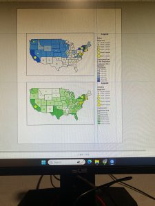
Chapter 3 was focused on sharing maps with people who either don’t have access to ArcGIS Pro, or have limited GIS skills beyond basic map navigation and interpretation. In the first tutorial, we created a map layout containing two maps, which helped us develop the skills needed to design any type of layout with one or more maps. In section 2, we learned how to share ArcGIS Pro maps by publishing them to ArcGIS Map Viewer. Next, we explored how to create a story using ArcGIS StoryMaps, and we concluded the chapter by building a dashboard in ArcGIS Dashboards