Chapter 7 this chapter introduced a few tools for manual digitization by tracing. By using base maps we learned how to create new feature classes and use base maps or existing layers for digitizing features. we also used lidar as a reference for heads up digitizing. Next we edited existing features and created features for a university campus. We added new structures, additions, and renovations to existing buildings. 
chapter 8- in section 1 of this tutorial we geocoded survey data collected by a Pittsburgh arts organization that holds and event each year. We used survey data if geocoded to look at potential marketing, philanthropy, and other forms of communication with its patrons. In section 2 we used the arts event data from section 1 to add street addresses and more detailed location data on attendees that would be desirable for the market. we also geocoded by street address to place unique points on the map for attendees.
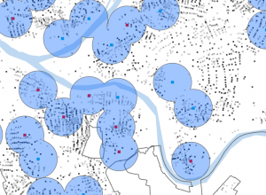
Chapter 9- we took a step beyond using visualization of spatial data to answer questions and solve problems. We covered four spatial analytical methods: buffers, service areas, facility location models, and clustering. This included building buffers and estimating gravity models nearest pool from their residences. This analysis suggested which public swimming pools to keep open during a budget crisis. We also used cluster analysis to investigate demographic and spatial patterns of arrested persons for serious violent crimes. This chapter also introduced the network dataset which is used for estimating travel distance or time on a street network.