My name is Zach White. I am an environmental studies major with a minor in Spanish and politics and government. I love basketball, fishing, and music.

I took the GEOG 291 quiz and it went smoothly. I wasn’t too particularly pumped about taking GIS but that was mostly likely in part due to the lack of involvement or familiarity I’ve had with it thus far. Coming in with little to no exposure, I would definitely not have thought that specialty doctors use GIS to discover or explore disease. If anything, I’ve kind of correlated it in my mind to GPS up until last year lol. Turns out GIS and GPS are indeed different. I like that the reading doesn’t target a technically minded audience but rather a more representative audience. This is helpful because as Schuurman points out, ordinary people use or are impacted by GIS daily without even knowing it’s at play.
When a problem emerges, it is fundamental to consider both the social context of the issue and the historical significance. It is critical to look into this because problems develop, go away, and reemerge through history, and problems are tightly connected to the societal conditions of when that problem persists. I learned this in my sociology course today and so I can appreciate the discussion of the identity of GIS and its pervasive relevance now in comparison to the historical implications. This also reminded me of the interdisciplinary nature of our liberal arts education through a GIS course in which different types of people use GIS in completely different ways with distinctive objectives. The history of how overlay became spatial analysis is intriguing. It is this historical advancement of technology that bolstered this transition and that continues to have an effect today.
I was a bit confused at the start of the reading when Schuurman explained that Geographers kind of opposed GIS. It became much more clear after reading about the history of GIS and how the analysis side of it differs from the physically visual and geographically based creations that are maps. Cartographers were familiar with their maps and not the information extraction and more detailed exploration that GIS offered. Maybe this is why I was not jumping out of my seat to learn GIS.
The following discussion of the visuality of GIS kind of contradicts why geographers may have opposed it, highlighting that GIS actually enhances this visual component by making this newer development more meaningful and more widely accessible. I like this because I definitely fall into the category of those who gain more information through visual arrangements than from a table with numbers or text. This idea that GIS goes beyond traditional analysis through its visuality is something that has made my interest in the course overall go up a bit.
The conversation of GIS as a software and GIS as a science is interesting. I never thought of the idea of a GIScientist but this seems cool. From my understanding, a GIScientist is more focused on the output and the evaluation of GIS input work while still considering the conditions of input and if that serves the output in one way or another. Through the connections that emerge through the inputs, my understanding of the main point for GIScience is that this process can then be justified and or contradicted based on its means of implementation. Through the investigation of input relationships, there then is this component of presentation that applies to GIScientists and researchers for which the diffusion of accessibly interpreted results is the goal. I think the increasing understanding of the importance of social influence on GIScience and GISsystems is vital in a world that is progressively dictated by the current society and its direction.
GIS application 1:
I’ve always been interested in sharks and their behavior as the apex predator of the oceans. I’ve also had experience tagging sharks when I was younger and I did research on the shark sanctuary conflict in the Maldives last year. There are various sites that show the movement of sharks along with other ocean ecosystem indicator species. GPS is used in terms of pinpointing shark locations and data is transmitted from the tag to a satellite. GIS is also used and like we read in the reading GPS and GIS are utilized by combining GPS with GIS. I found this one site that centers a non profit working to expel data that has been unattained or unexplored in an effort to assist scientists and other sectors like education and policymaking.
![]()
Tracking, M.-W. (n.d.). Ocearch Shark tracker. Retrieved from https://www.ocearch.org/tracker/

While in this first display, GPS is largely at play, the next depiction from the same organization shows more clearly their implementation of GIS to go beyond a location and explore spatial patterns and relationships across layers:
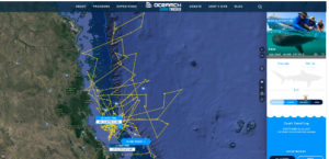
https://www.ocearch.org/tracker/
GIS application 2:
For my interest in politics and government I wanted to look into the role of GIS in politics, particularly elections. I found a really cool study done by Harvard University that investigated how GIS can assist in understanding the conditions of elections and how things like jurisdictional complexities impact elections and the people at the core of these processes.
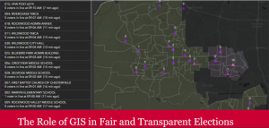
The role of GIS in Fair and transparent elections: Data-Smart City Solutions. (n.d.). Retrieved from https://datasmart.hks.harvard.edu/role-gis-fair-and-transparent-elections