Hello. My name is Ben Lindley and I am a sophomore. Unfortunately I don’t really have any good pictures of me so this is the best I could do.

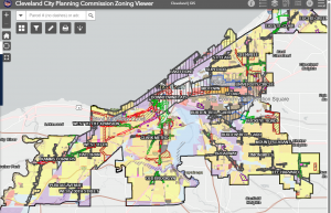
One thing I found interesting about the reading is that GIS is used in everyday life. It affects millions of people in a number of ways. What we eat and where it comes from as well as how we get to certain places all rely on GIS. GIS is also very important with urban life. I also found it interesting that GIS is not only rooted in computer labs in the mid twentieth century. There have been attempts made in the nineteenth century to automate calculations for example in the 1890 census. The reading also gives a good visual about the cholera outbreak in London in 1854. Because of this Dr John Snow was able to make the connection between water pumps and the spread of cholera. I googled GIS applications on navigation and found out that GIS enhances navigation in many ways. One big example of GIS in navigation is Google Maps. It helps with mapping and visualization. GIS excels at creating interactive maps. It also helps with urban planning and management to analyze traffic patterns, identify congestion points, and optimize transportation infrastructure. This contributes to smoother traffic flow and improved public transportation efficiency. One thing that surprised me the most was that GIS is used in drone navigation. I also googled GIS Applications in Cleveland and found that GIS is used in neighborhood planning and zoning. Here is a map on clevelandohio.gov website.
https://data.clevelandohio.gov/apps/f15dec13ee6648bcb218d4f5c8290691/explore