Hello, I’m Dylan Patel and I’m a Jr currently majoring in Environmental Studies. I’m from Anaheim Hills near Disneyland.

Learning about GIS was spectacular. I didn’t know that GIS had so many applications in industries like Starbucks to maximize its store placement, epidemiology for identifying infectious disease clusters, and even law enforcement for crime mapping. Of all of these, epidemiology surprised me the most because I always assumed GIS was mainly for cartography and city planning.
I was also intrigued by how, in the 1950s-1960s, there was pushback against digitalization. At the time, computer-generated maps were considered crude compared to the artistry of manual cartography. Yet pioneers like Brian Berry, Waldo Tobler, and Duane Marble in the US, and Tom Waugh and Ray Boyle in the UK, pushed forward with algorithms and code that laid the foundation for spatial analysis. That persistence transformed GIS from “computerized cartography” into a powerful analytical science (Schuurman, 2004).
Connecting GIS to epidemiology is especially fascinating. A famous historical example is Dr. John Snow’s 1854 cholera map in London, where plotting deaths around contaminated water pumps revealed the true source of the outbreak. That map demonstrated how spatial visualization could unlock hidden relationships in health data. Building on that legacy, epidemiologists today use GIS to identify disease clusters, track outbreaks, and assess environmental risk factors. For example, GIS has been used to study cancer incidence in relation to toxic exposures, evaluate where infectious disease cases are concentrated, and plan interventions for public health emergencies like COVID-19. What makes GIS so powerful in this field is its ability to merge multiple layers-population density, environmental hazards, transportation routes, or healthcare access-and reveal patterns that would remain invisible in raw tables or reports. As Rushton (2003) argues, GIS provides health officials with spatial analytic tools that can improve both research and decision-making, ultimately saving lives.
Overall, Chapter 1 made me realize GIS is more than just “maps.” It is both a science and a system-one that influences how we see, organize, and act upon the world. As an environmental studies student, I can see myself using GIS not just for conservation, but also to understand how environmental health risks connect to human populations.
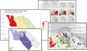
Source: GIS basics page, The Epidemiologist R Handbook (used for the illustrative image) EpiR Handbook
An example of how GIS is used to track the spread of diseases and relative populations.
______
Schuurman, N. (2004). GIS: A Short Introduction. Oxford: Blackwell.
Rushton, G. (2003). Public health, GIS, and spatial analytic tools. Annual Review of Public Health, 24, 43-56.