Hi, my name is Jes Powell. I’m a senior and I am majoring in Studio Art. I am from the Cayman Islands and I live/grew up on the beach. I love photography and writing.

Chapter 1 of Schuurman’s GIS: A Short Introduction discusses the importance of Geographic Information Systems (GIS) and how it can be found everywhere. GIS is used for a variety of different tasks and oftentimes people don’t realize how extremely impactful it can be. To each individual GIS is important and effective for various different personal reasons. For example in a city GIS can be crucial when it comes to planning residential, industrial, and commercial zones; this is just one of the many ways that GIS can be used. GIS uses mapping and data analysis to find solutions and allows for data to be interpreted in a way that can be an aid for planning and research. There are two main components of what the acronym GIS stands for; this being GISystems and GIScience. GISystems more so focuses on ways of analyzing and mapping out data and is more commonly thought of when considered the acronym GIS. On the other hand GIScience focuses more on the overall explanation of questions related to how GIS software puts out its output. I think it’s interesting that there are two different meanings to the acronym of GIS and that it is not just simply Geographic Information Systems. The most important part about these two faces of GIS discussed in this section of the chapter is how spatial phenomena is translated into digital terms; this is essentially what connects both GISystems and GIScience. GIS is an extremely diverse tool that impacts everyday life for a majority of people. I think most people don’t realize that GIS goes beyond just something that is technological as it can be the deciding factor for numerous things. GIS technologies have a major role in food production and agriculture, and can impact government and business decisions. GIS technologies impact every part of our life and it is an important tool to understand what is used for and what exactly it means and what type of data is getting taken in and what data is being outputted.
GIS Applications
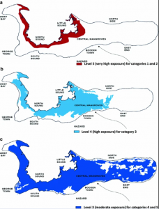
- I looked up how GIS applications are used for the Cayman Islands and I found how it can be used in Grand Cayman (the main island) to determine which areas are more exposed to flooding and which areas are more exposed to specific hurricane categories. I think this is important information to take into consideration as it can be necessary for future plans of how land is used and what developments are made.

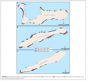
https://link.springer.com/article/10.1007/s11069-010-9539-0 - The second thing I looked up related to GIS applications is how it can be used to see the specific areas in the Cayman Islands that are turtle habitats. This is important as these areas are protected during turtle nesting season and there are specific turtle nesting sites that you are not allowed to go to so that the process isn’t disrupted. I think the use of GIS applications to be able to see this information is crucial because it ensures that these marine animals are able to safely and effectively go through their normal process of nesting and returning to the ocean without natural and man made obstacles that would otherwise prevent them from doing so.

https://www.frontiersin.org/journals/marine-science/articles/10.3389/fmars.2021.663856/full