My name is Hazel Jolliff. I am a Junior and I am majoring in Environmental Science. This is only my second year as an Environmental Science major so I am still kind of new to it all. I run Track & Field here at OWU and my main event is javelin. I am a commuter and I live on a farm and i love my pigs, so that is fun! Other than that I’m taking this course to learn more about GIS and get an idea of how it all works.

The Shuurman reading was very interesting to me. GIS is a pretty new concept to me and I didn’t realize how much it affects our everyday lives. There are alot of people and places that depend on GIS for things. The reading explained the beginnings of GIS and how it was just a regular map with different layers on top. I thought this to be pretty simple but it explains that with technology now, it is much more efficient and has expanded more than what it originally was. The reading talks about the early computers and how they weren’t able to do nearly as much when it came to GIS as they can do now. Even though the first computers weren’t around that long ago it shows that GIS has come a long way in a short amount of time. I find this interesting because GIS seems to have a hold on the way things function in this world. It says in the beginning about how Starbucks uses GIS to figure out where its best coffee shops are. And it seems fairly obvious that Starbucks also has a hold on the way things function in this world. Big businesses, all the way to farmers/ranchers figuring out where to graze their livestock, GIS is an important resource and I guess this reading really opened my eyes to that fact. In the first section of the reading there was a paragraph or two explaining that some Academic Geographers have a love/hate relationship with GIS. Going on to say that GIS is only “one lens on the social and physical world” so I’m wondering if academic geographers are concerned that too many young people are going to only focus on GIS instead of the other forms of mapping and what not.
My Searches:
#1. My search was “ GIS” and “Crop Damage”
Reference: Lou, W., Ji, Z., Sun, K., & Zhou, J. (2013). Application of remote sensing and GIS for assessing economic loss caused by frost damage to tea plantations. Precision Agriculture, 14(6), 606–620. https://doi-org.owu.idm.oclc.org/10.1007/s11119-013-9318-5
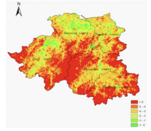
The article titled “Application of remote sensing and GIS for assessing economic loss caused by frost damage to tea plantations” focused on developing a way to determine economic loss due to spring frost in tea plantations. The map used remote sensing and GIS to form a spatial distribution of temperatures in the given production area.

#2. My search was “ GIS Application” and “Archaeology”
Reference: Ebert, D. (2004). Applications of Archaeological GIS. Canadian Journal of Archaeology, 28(2), 319–341.
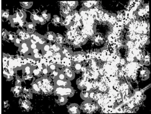
The journal was titled “ Applications of Archaeological GIS”. This is an example of a predictive model, the dark circles represent existing sites that were used to base the model off of.