Hi, my name is Ethan Shaw and I am majoring in Economics with a minor in Accounting from Woodland Park, New Jersey. I am hoping to find a job in finance or consulting after I graduate this May. I have never used ArcGIS or any GIS software, this class seemed interesting to take.
I never realized how much GIS is used outside of the environmental field of work. I was interested in taking this class because in the professional world especially in economics when looking at developing nations or areas in the US. I did not know there was a difference between mapping and spatial analysis and that there were different variations of mapping in GIS. I also never knew that GIS was a technology that has been around for over 50 years and always thought of it as a new technology that was just being discovered, it is also amazing to me that GIS started without using a computer and just handwriting code out. GIS is now being used in many different industries. I was completely unaware of just how much GIS is used in our day to day lives and what decisions are made by it. GIS is used in many municipalities when determining crime rates and how these are affecting the areas. These maps are also able to tell you why areas see more crime than others and why there might be a spike in a certain crime. GIS is also used in many large companies to help with growth within the company. Large fast food companies use GIS to determine based on all sorts of factors where the best place would be for their restaurants or stores.
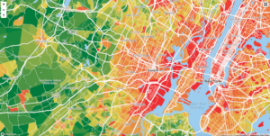
The map below is of the crime rates in Essex county NJ. Mapping this out allows officials and people to know generally what areas are seeing more problems than others and what type of crimes are prevalent in these areas.
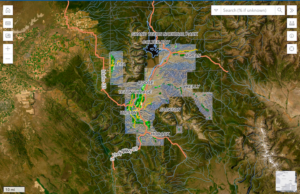
This map shows the urbanization of Teton county Wyoming. This is showing like most sought after vacation spots in the US how masses of people moving in are slowly taking over and leaving these places almost unrecognizable.