Uible Week One


Introduction: Hello, my name is Henry Uible. I am from Jupiter, Florida, and Dothan, Alabama. I am majoring in history and minoring in geology. With a background in history and geography, I plan to teach or work in national parks; hopefully, this class and working with GIS will give me an advantage in getting jobs in these areas. I am new to using GIS and all that entails, but I am very eager to learn and get started.


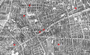
Reading: It’s interesting to see that college students are lining up to take GIS classes, and that GIS software is generating significant revenue. It’s also interesting how GIS got started in the 60s by some dude using a map to figure out how to build a road that would help his community. It’s interesting to see that when GIS was first being developed, people doubted its usefulness and questioned whether it would benefit many. Sounds like every government around the 1980s wanted to build a GIS system to compile data. It is interesting to see how GIS is used, especially in the modern day. It’s also interesting that it’s not just scientists and students who are studying geography or using GSI for. In the reading, it stated that even farmers and. People doing landscaping use GSI to make sure they’re not damaging the environment by cutting down trees and that they’re growing their crops in the right place to ensure continued crop growth. One of the figures in the reading shows the historical context of cholera breaking out in London in 1854, which is really interesting to see because you can point out where major outbreaks occurred, where specific outbreaks could have been sealed off to save more people, and where particular wells were found to contain cholera, with this diagram. I think I’d also be able to show us many things for medical research, including where major outbreaks could occur and where we could quarantine specific areas. A map like this might also help paramedics and police officers determine where more medical assistance is needed in a city or town, as well as the fastest route to the area that needs it most. One of the takeaways from this was that GIS is not just for scientists; it is for everyone, and everyone can use it.

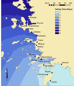
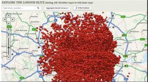
Historians are using GSI to understand better how battles unfold and why specific tactics were used, particularly when they occurred a couple of hundred years ago, when the terrain around them was destroyed by erosion or other Means. Well, GSI is also used to determine distance by looking at travel-related items from the ancient world shown in the first image. It shows how long a trip from Rhodes to many other parts of ancient Greece and the Mediterranean would have taken. Second image, they’re showing off the bombing of London from the German attacks, specifically during World War 2 of, where all the bombs were explicitly dropped on London. 

I also took the quiz


Using Landsat Imagery to Find Shipwrecks – Geography Realm

About: Bomb Sight – Mapping the World War 2 London Blitz Bomb Census

Butte Week 1

My name is Mia Butte, I am a freshman at OWU who is planning on doing a double major in Film and Biology (possible to change to Environmental or Earth Science). I am highly interested in Paleontology so I wished to study Geology- but as it’s not offered anymore, I plan on taking similar courses with an alternate major to fulfill this interest. I am a commuter from Lewis Center, and have a passion for all creative arts as well as evolutionary and paleosciences. I hope that I can find ways to bridge art and science during my time at Wesleyan.

After reading the chapter the biggest takeaway for me, in connection with my interests, is the direct use for archeological sites and research. This was both something I knew about when entering the class, and the main reason why I decided to learn the skill. That being said, the reading provided much more information as to what GIS actually is and how it’s used as a tool. I learned that GIS sort of developed through technological evolution- that GIS was developed as a collective of similar research from many different locations. It also wasn’t initially made with Geography in mind, but rather for Architecture and population censuses, which I thought was interesting. One thing that surprised me was how many different uses the system has, spanning across all kinds of fields and daily encounters. I didn’t realize it was something that was actually used every day rather than for specialized projects/ research. For example, city development plans have to account for where certain buildings and facilities are built, using GIS and data points to map out the best areas for construction. But it can also be used to map out GPS and routes on everyone’s phones/ vehicles. It’s also interesting that there are so many different interpretations of GIS, between being GISystems vs. GIScience (and viewing it with a scientific approach), and many opinions on the “correct” definition or use. Whatever the opinion is, it remains the fact that GIS has many different levels to it, varying between each field of use. To put it simply, GIS is the visualization of data, turning tables and numbers into easily understandable maps. Most people I told about this class were confused and said GIS was something that they had never heard of before. They might recognize a map or GIS application, without understanding its meaning or use towards their lives. This chapter helped me develop a deeper understanding of these systems myself so that I can better explain its concept and uses to those who are initially confused, but interested in learning more.

GIS Applications:

I have always found it interesting that there have been bear sightings in Ohio, considering the landscape here. This GIS map report shows the amount of sightings since 1993, and the regions they can be found in.

Link: https://dam.assets.ohio.gov/image/upload/ohiodnr.gov/documents/wildlife/wildlife-management/blackbearreport.pdf 

Similar to the last application, this map follows sightings of an animal thought to have been extinct in Cleveland since the 1800s, but has recently made a comeback.

Link: https://www.news5cleveland.com/news/local-news/fisher-spotted-on-cleveland-metroparks-trail-camera-animal-hasnt-been-seen-in-cuyahoga-county-in-200-years 

Lastly, I completed the quiz!

Gustav (Samuel) Week one

Yes, I did take the quiz.

I go by Gustav but my boring name is Samuel. I am an english major who is taking this class as an upper level Gen Ed.

I found the chapter to be very interesting.  When I was given the introduction to this class I had ben informed of the multi-disciplinary applications this knowledge could have but reading the chapter really put things into perspective for me, as the chapter seemingly had a way to trace nearly every sector of out lives back to GIS applications. I especially found the passages regarding the applications for precision farming and for utility companies to be particularly interesting given that I feel those are sectors of life that most people don’t give much of a second glance at in day to day life and it is very enlightening to see just how much work goes into these fields using GIS alone all for the common man to simply ignore them on the basis of “out of sight, out of mind”.

I think my biggest takeaway fro the chapter was the knowledge on the subject of GIS itself. My first impressions as someone who had never seen that acronym before was that was the name of a commonly used computer program sed to conduct geographical analysis in a similar way to how business students are taught to use Microsoft Excel or how Engineering students are taught with Autodesk Inventor. Upon reading more (and coming across the interesting history of GIS dating back to the 19th century which I found to be absolutely fascinating) I found out that my initial assumption was quite wrong and that GIS is much more of a scientific field in itself given the vast ways geographical data could be gathered and interpreted.


The main application I am curious about is Geographical Criminal Profiling. I have a minor interest in criminology (though I have received no formal education on the matter) and GCP is very commonly used in many criminal investigations.

Source: https://atlas.co/gis-use-cases/geographic-profiling/

Something I think would be interesting to do in this class is using the GIS software I could create a geographical profile of the infamous Jack the Ripper murders in the autumn of 1888. I find most maps on the subject (below) tend to be rather unenlightening and not particularly interesting for nerds like me as they tend to include many non-canonical events in their analysis  (The map I have included in this post from Wikimedia commons is one of the worst offenders in my opinion) and I personally would like to see one based much more in the facts rather then the insane amount of theories.


Whitfield Week 1

  1. My name is Akiilah Whitfield, I’m a first year student at Ohio Wesleyan. I plan to double major in Environmental Science and Zoology with a minor in Astronomy. I’m excited to take this class and learn more about GIS and how it relates to my fields of study while simultaneously learning new skills that will benefit me in the future. I have interests in reading, playing the guitar, baking, building lego sets, and sometimes watching NatGeo nature documentaries. In the future I hope to possibly get my doctorate in  a specialized environmental science field that is focused on animals and conservation. I want to do field research in the tropics and other densely populated vegetation places. I plan to stay in Ohio for my undergrad and then move to a new state or country when getting my masters and doctorate. I’m really excited to continue this class and learn more!


2. Through reading chapter 1, I was able to get a more clear and concise understanding of what GIS was, and what important role it serves as a means for mapping with the use of technology and science as well as the way different people and groups interpret it. I learned that GIS is a widespread tool used for different fields like public health, urban planning, agriculture, marketing, transportation, environmental planning, and more. The growth of GIS out sees some people’s understanding of it and its social implications. As stated before, GIS means different things to different people: for researchers its used for a scientific approach while for city planners and other people in the field, it’s more of a platform that answers questions like “where”. This makes GIS lack a single defined identity which causes tension and a lack of understanding within the geography field. GIS first appeared in the 1960’s paired with advances in computing and quantitative geography. One word that I learned in the reading was “spatial overlay”, which was defined by Ian McHarg as different layers of spatial information that are analyzed together. Early GIS was disregarded and referred to as the inferior computerized cartography because it didn’t have the same kind of aesthetic quality of hand-drawn maps, overlooking the true power that it had. GIS came from cartography, surveying, landscape architecture, statistics, and computer science. There was the argument between if GIS is, or is not linked to quantitative revolution. Other groups believe that GIS goes beyond quantitative methods because it incorporates institution and visualization. GIs has the ability for people to view spatial patterns which in turn makes analysis more accessible and interpretive as opposed to just being numbers. I also learned about GISystems and GIScience. GISystems is software, hardware, and procedures that are used to collect, store, analyze, and display data. GIScience is seen as the foundation of GIS which examines how spatial data is modeled, classified, analyzed, and visualized.

GIS Application 1:

This map shows tracking and monitoring of animals and farm livestock through sensors attached to the animals used for monitoring herds that are long distance or farther away. This specific study is an experimental trial with a custom-device fit for a collar and took place in two different grazing areas in different zones territorially. 

https://www.sciencedirect.com/science/article/pii/S2405844024091977 


GIS application 2:

The second GIS map that I chose is related to Tasmanian Devils and the tumor disease that they were, and still are developing, killing a large portion of the population. Through GIS scientists learned that the animals would eat roadkill or other food that gave them the disease, and then would communicate with other animals that would also eat the food and in turn, also get sick. The map helps scientists understand threats to the population that killed the animals which they then investigate, helping to boost the number of Tasmanian Devils while keeping the number of infections low.  

https://science.sandiegozoo.org/science-blog/mapping-devils-playground-boosting-populations-gis 

5. I finished the quiz!


Isaacs Week 1

I am Henry Isaacs a Quantitative Economics and Data Analytics Major. I enjoy the outdoors and being on the water especially when I am fishing. I also play baseball here at OWU.

Schuurman Chapter 1:

With no prior knowledge on GIS, reading this chapter I quickly realized that it is far more than a mapping technology. What I took away most strongly is the idea that GIS creates dynamic maps that aren’t fixed on a page but can be queried, layered, updated, and reinterpreted depending on the question being asked. This flexibility makes GIS feel less like a static representation of the world and more like an analytical tool. You can zoom in, turn layers on and off, change classifications, or run spatial analyses, and each of those choices reshapes what the map reveals.

The chapter’s explanation of the two core data models, the vector and raster, also helped ground the technical side of GIS. Vector data, with its points, lines, and polygons, captures discrete features like buildings or roads, while raster data represents continuous surfaces such as elevation or temperature. Understanding these models made it clear why GIS is so versatile: it can represent both the things we can point to on a map and the environmental conditions that surround them.

Another major theme I took from the reading is that GIS is deeply shaped by human judgment. Decisions about what to map, how to classify data, where to draw boundaries, or which layers to include all reflect choices made by people. GIS isn’t neutral it contains assumptions, priorities, and sometimes power. This kind of surprised me because although most human generated things contain errors it seems they are hardly mentioned or don’t effect the final result very much.

Finally, the chapter highlights the wide range of applications, from environmental management to business logistics, or even emergency response. The idea that GIS can help responders identify evacuation routes, assess risk zones, or allocate resources shows how large of an impact this technology has that I hardly knew existed.

Overall, GIS is widely applicable and I am interested in learning more about it.

GIS Application 1:

https://ohiodnr.gov/business-and-industry/services-to-business-industry/gis-mapping-services/gis-mapping-services

Something that I am interested in and I found that GIS has a large application to is recreational fishing. I found a map given by the ODNR showing fishing depths and locations in Lake Erie around where I live.

GIS Application 2:

https://www.arcgis.com/home/item.html?id=340969acd47a4e2ca70a24d1c8f32f0b 

I also found that GIS can be used for inspecting water quality. I even found the area where the water I use at my house comes from. I could look at the quality of it and where that drinking water goes out to.

Quiz completed.

Spurling Week 1

Introduction: My name is Jessie Spurling, and I am a senior majoring in Biology and Psychology. I’m from Lancaster, Ohio (Hocking Hills area). My on-campus activities include being on the softball team, a tour guide, and a member of the Delta Zeta sorority. After college, I intend to pursue a career in conservation/ecology or environmental education, and I feel that GIS will significantly help me with those future endeavors.

Schurmann Chapter 1:  In the first chapter of GIS: A Short Introduction, Schuurman explains what Geographic Information Systems (GIS) are and why they are important. She starts by defining GIS as a way to collect and analyze data that is connected to location. What stood out to me most is that she makes it clear early on that GIS is not neutral. Even though maps and data often look objective, they are created by people, which means human choices and biases are always involved (boo).

Schuurman also explains how GIS works by combining maps, databases, and computer technology. She talks about layering data, such as putting population information on top of environmental or political data, to better understand patterns and relationships. This helped me understand why GIS is such a powerful tool and why it is used in so many areas like city planning, environmental studies, and public health.

Another important point in this chapter is how much influence GIS can have. Schuurman explains that because GIS outputs look scientific and authoritative, they are often trusted when making decisions or policies. However, she warns that if the data going into GIS is incomplete or flawed, the results can still look convincing even if they are inaccurate. This made me think more critically about how much we trust maps and data without questioning where they come from.

GIS Applications: The first GIS application I looked at was Assessment of habitat suitability and connectivity across the potential distribution landscape of the sambar (Rusa unicolor) in Southwest China. This application uses GIS to map where sambar deer are most likely to live and how different habitat areas are connected. I focused on the habitat suitability map, which shows areas ranked from low to high suitability. Darker shades on the map represent areas that are more suitable for the sambar.

I noticed that the most suitable habitats were clustered in mountainous and forested regions of Southwest China, while areas with lower suitability appeared in more developed or fragmented landscapes. Some of the high-suitability areas were separated by large regions of low suitability, suggesting that the habitat is not well connected.

www.frontiersin.org

Front. Conserv. Sci., 19 January 2023 Sec. Animal Conservation Volume 3 – 2022 | https://doi.org/10.3389/fcosc.2022.909072

The next GIS application I examined was Impacts of spatio-temporal change of landscape patterns on habitat quality across the Zayanderud Dam watershed in central Iran. This study uses GIS to analyze how land use and land cover have changed over time and how those changes affect habitat quality. I focused on the habitat quality maps, which show areas ranked from low to high quality. Darker colors on the map indicate higher habitat quality, while lighter colors represent more degraded habitats.

I noticed that areas closer to urban development, agriculture, and the dam itself showed lower habitat quality over time. In contrast, regions farther from human activity, especially natural and undeveloped areas, tended to maintain higher habitat quality.

Habitat quality map in 1991, 2021 and, forecast map of habitat quality in 2051. This map was generated using ArcGIS 10.5 software (URL: https://www.esri.com/en-us/arcgis/products/index).

Phillips, S. J., Anderson, R. P., & Schapire, R. E. (2006). Maximum entropy modeling of species geographic distributions. Ecological Modelling, 190(3-4), 231–259. https://doi.org/10.1016/j.ecolmodel.2005.03.026

Quiz: Taken.

Hughes (Elliott) week 1

My name is Lane Hughes. (It will appear as Lane Elliott until this gets fixed by the registrar).  I just switched majors from Business Management to Environmental Studies. I found that business didn’t align with my values. I am a commuter student. I work at Cackler Tree Farm. My sister also attends OWU and my brother will be next year. 

My biggest takeaway from the reading is that I am among those that did not recognize the GIS acronym or how it affects my daily life. Chapter one of Schuurman’s work explains pervasive GIS is in modern life, but also how it began. In its origins, people were reluctant to use it or acknowledge its usefulness. GIS is used in so many different ways that it is hard to define. The idea that GIS is simply a computer program is what Schuurman wants us to get away from. GIS has shaped much of the current world. Policies are made based on information obtained from GIS. The beginnings of GIS were based on industry needs. It is important to remember that although GIS is computerized, it is still reliant on human input. Therefore, it may not be error free. GIS can also be thought of as an academic discipline to be studied. Schuurman believes that because there is room for error and so many different purposes, GIS should be used with an understanding of its vast abilities, but also its limitations. GIS is extremely influential in our world today. One part of this chapter I enjoyed was the story of how one of the early computer cartography systems was developed. It is wild that something that became so fundamental began by two guys who happened to sit next to one another on a plane and share a common need for a system such as this. After reading this, I still have a lot of questions. One question is if GIS can be objective, since data and classification is determined by human input? Additionally, if there is a lack of objectiveness, what is misrepresented and how would one know? 


GIS Application One: https://storymaps.arcgis.com/stories/a08e4636ef6945b0a1a93820bcb334ca

Nesting Sea Turtles on a Changing Caribbean Island shows interactive maps where turtle nesting sites are located and how these locations have changed over time. Research collected helps management practices. This is valuable because it helps with decision-making and influences policies. 

GIS Application Two:

https://www.esri.com/arcgis-blog/products/arcgis-pro/mapping/how-to-make-this-animated-map-of-blue-whale-migration

This application walks through the GIS project of tracking Pacific blue whales on their migration. ArcGIS Pro is used for this. 

I completed the quiz!


Koob Week 1

Hi, Im Jenny Koob! I am a freshman at OWU, and I am planning on majoring in Environmental Science and Botany, with a potential minor in Geography! I’m fascinated by how our ecosystems work and learning more about climate change, as well as the impact humans have on our ecosystems. Aside from my major, I really enjoy being outdoors, traveling, listening to music, playing guitar, and spending a lot of time with my friends.

Schuurman ch. 1 reflection

Before reading this chapter, I didn’t have much idea about the details of GIS. I knew I would figure it out soon enough within this course, but to have it laid out in a chapter actually really helped me grasp it. All of the examples of the usefulness of GIS were already quite intriguing, but to learn that even Starbucks (my literal job) also uses it shocked me! There are so many careers that find GIS so helpful to their work, its actually pretty encouraging. The more I learn about it, the more it makes sense on how it is integrated into so many parts of our world.

It also discusses the statistical side of it, and what questions people have to ask from all angles to work with the computers correctly while getting the data they want out of it. Spatial analysis is considered a completely separate thing from mapping, which is interesting. The development of ESRI was also neat to read about, especially as an envs major. This part: “Although some human geographers claim that CIS is a direct descendant of the quantitative revolution, CIS researchers are loath to accept this simplistic genealogy.” was, again, so shocking to me. I had no idea about all the discourse and opposition geographers faced with the newfound tech. Even if GIS is revered by many, I didn’t expect it to be seen as something to not accept.

As the reading goes on, it talks about how we as people interpret and perceive information, and notes that a majority of scientists argue that people “reason” through imagery. Which is very true in our society; you can see this everywhere: from grocery stores putting imagery of foods and items for buyers to easily interpret, to our road signs, to the way we even learn the alphabet. As a society, we use visuals to absorb and learn information, and I think this is a really intriguing part to note. Plus, I like the topic of “fuzzy lines” because it shows how unrealistic it is to put everything in boundaries and lines (as much as it helps GIS). As the reading wraps up, the distinction between GISystems and GIScience is very confusing, honestly, and I hope I learn more about it.

GIS applications– Coral reefs and the Redwoods

The first application I found with GIS was with the mapping of coral reefs. GIS helps scientists map, monitor, and analyze coral reef ecosystems by combining spatial data from satellites, drones, and field surveys to track changes over time. As climate change, warming ocean temperatures and ocean acidification continues, so does coral bleaching and habitat loss. GIS visualization shows spatial patterns of reef distribution and associated threats like thermal stress or human impacts.

https://cdn.cosmicjs.com/efd06f00-c3ba-11eb-b193-5346a49faa02-Mapping-regions.png

The second application I was able to find was with California’s Redwoods.

GIS is used to map, monitor, and conserve redwood forests, especially along the California coast where the coast redwoods grow. By combining satellite imagery, elevation data, climate layers, and land-use information, GIS helps scientists understand where redwoods exist today, where they existed historically, and where they may survive in the future under climate change. I was actually lucky enough to have seen the Sequoia National Park last year, and hike through the forest of Redwoods. It was truly such an amazing experience, and I am very passionate about what I can do to help protect these trees.

Esri ArcWatch October 2010 - Conserving Earth's Gentle Giants

I also completed Quiz 1! 🙂

Moore Week 1

Intro: Hello, my name is Alayna Moore. I’m a Sophomore, and I transferred to OWU at the end of my freshman year.  Delaware Ohio is my hometown, so I always wanted to go to OWU. I plan on double-majoring in Biology (B.A) and Environmental Science (B.A). As for a career, I want to spend time in the field doing surveying. I’m interested in working as an environmental consultant or working for a national park. I also have a deep interest in fungi and have written many amateur scientific papers about them. I’m very new to GIS, but I hope it will help me succeed in these fields of work. In addition to this, I enjoy knitting clothing and doing graphic design when I have the spare time.

Chapter Reflection: After reading the GIS textbook chapter, I learnt a lot of new and interesting information that I was previously confused about. I was largely unfamiliar with the concept of GIS as a whole. I knew it involved mapping and was used in the environmental science field, but that was the extent of my knowledge. Through reading the chapter, I learned that GIS can be applied to various fields and topics. For example, a city planner, a police officer, and a research scientist may all use GIS within their work for different purposes. As a result, GIS can have a massive effect on our societal function from its pervasiveness across multiple important disciplines. I also learned that Spacial analysis is one of the core functions of GIS. Spatial analysis represents more than just geographical data in a visual form, as seen with basic maps. It allows us to gain knowledgeable insights on the data being explored through using a Geographic Information System (GIS) as a tool.  One part of the chapter I found interesting was when early forms of geographic information systems were being discussed, specifically the formation of the Canada Geographical Information System (CGIS). This was one of the earliest operational computer cartography systems as it was created in the 1960’s. I found it interesting because it was created out of a want to gather data on the Canadian forests for the purpose of land management by overlaying the land data with other relevant structures like soil layers and urban areas. This was a wanted concept because this creation would allow for analysis of large amounts of data to determine how one might efficiently manage Canadas forests. As someone who is interested in the surveying and management of land as a potential career path, it was insightful to learn that one of the earliest computer cartography systems was created for that express purpose.

GIS Applications 1:  As previously mentioned, I am deeply interested in fungi and their environments. This led me to discover a scientific report on the topic of mapping soil fungi within a specific region. The researchers decided on mapping the fungi species located in Wielka Żuława island in northern Poland in order to provide a baseline for a new approach towards mapping landscape-scale fungi distribution patterns. The researchers succeeded in their venture of depicting large-scale landscape mapping of the distribution of specific soil fungi within the region, as depicted below.

Source 1:  https://doi.org/10.1038/s41598-023-37538-7

GIS Applications 2: Another topic I am interested in is Invasive species. I find their rippling impacts they have on the environments they are introduced to extremely interesting. Because of this interest, I found a paper published by the U.S. Department of Agriculture relating to the control of a invasive plant species. More specifically, the paper highlights the potential of handled GIS technology in monitoring the control of the species. The paper acknowledges that within Arizona, there are many different invasive species of weed that are impacting the function of Arizonas ecosystems. One solution that is highlighted is implementing the use of handled GIS systems for landowners and managers within Arizona to operate, allowing them to gather and plot data on the invasive weeds. This ability to digitally gather data may allow for more efficient and accurate information on the location and spread of the invasive weed.

Source 2: https://www.fs.usda.gov/rm/pubs/rmrs_p036/rmrs_p036_298_301.pdf

Njoroge Week 1

Introduction: 

Name: Ariana Njoroge

Hometown: Nairobi, Kenya

Major: Environmental Studies

Minor: Psychology

Interests: Drawing,  Reading, Photography, Music, Dance, Crochet, Psychology


Schuurman Chpt. 1:

Schuurman ch.1 covers the basics and origins of GIS (Geographic Information Systems)  as a science and a discipline, and talks about how it has become so prevalent in the daily lives of millions of people world wide. From GPS to disease control, GIS is used in hundreds of fields, from commercial/industrial to agricultural work. I find this interesting because it means that based on the nature of the issue you’re dealing with using GIS, it influences the way GIS can be defined.  GIS at its core is concerned with data input, analysis, mapping and output of spatial data. The origins of the concept of GIS can be traced back to researcher Ian McHarg, a landscape architect, wanted to examine the effects of the construction of a new highway on a suburban area. To accomplish this he placed multiple pieces of tracing paper on a light table, using each piece to represent a layer. This was one of the earliest development stages of GIS; the use of tracing paper to represent layers is a metaphor of the overlay function.

Two of the main concepts of GIS is the analysis and display of spatial data. However, technology did not develop enough to accomplish this until the early 1960s by researchers in the US. The combination of aerial photography and the development of computer systems that could categorize land zones into layers (eg. wildlife, recreational areas) created the foundation for future GIS technology to build from. In the 1980s, a more efficient method of computerized overlay came to be. This involved the utilization of polygonal/vector boundaries, and added an entirely new dimension to how GIS could be utilized in a more user-friendly way. Visualization can help us give data meaning, and the development of polygonal imagery allowed geographers to see and understand spatial patterns in any given region. This allows GIS programs to be utilized in a multitude of differing fields, and is exactly what makes it so interesting as a discipline. It has come a very long way over the decades and will slowly but surely become one of the most vital technologies in the modern day. Overall I thought the chapter was a great introduction into GIS. I found it’s origins very intriguing, and look forward to see how I learn to interpret and use GIS through this course.


GIS Applications

1. Agriculture: GIS provides accurate, comprehensive data that aids decision making and planning. An example of this would be sensors placed in the soil that record temperature and moisture levels to ensure crop health.  It can help farmers determine whether some crops will grow better than others in certain seasons, or determining how climate changes could affect crop health. This can be especially helpful for smaller-scale farmers who are particularly vulnerable to climate issues. 

2. Enterprise decision-making: GIS software enables companies to make decisions regarding customer segmentation, real estate management, as well as transport and delivery management. GIS also allows companies to secure and allocate resources, as well as ensure efficient field service management. This will allow business operations to run smoothly, in that customer issues and complaints can be resolved. In the long run, it reduces downtime and costs while increasing customer satisfaction.


Applications of (GIS) Geoinformatics in Agriculture - GeoPard Agriculture

Source:

Mathenge, M., Sonneveld, B. G. J. S., & Broerse, J. E. W. (2022). Application of GIS in Agriculture in Promoting Evidence-Informed Decision Making for Improving Agriculture Sustainability: A Systematic Review. Sustainability, 14(16), 9974. https://doi.org/10.3390/su14169974