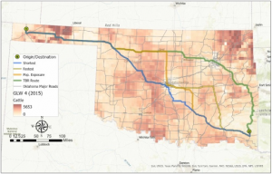
Deem Week 2

Mitchell Chapter 1:

This chapter helps highlight some of the basics to begin getting into GIS software and digital mapping in general. It starts out by guiding the reader through the process of using GIS to create a map by first understanding the data that will be used to create the map. Next, you have to choose a method to present the data based on the purpose of creating the map in the first place. The data must then be processed through GIS software to be displayed as a map, which can be tweaked by the creator in order to display the information in the most appropriate way for the situation. This chapter also goes into detail about several important terms related to GIS. Geographic features are map items that can be described as either discrete (definitely occurring or not occurring in a given position) or continuous (intensity of occurrence varies based on position). Another important term described in this chapter are the two different ways of representing geographic features in GIS, which are vector and raster. Vector models describe features on a map using x,y coordinates and connecting them with lines and can be used to show the location of specific events. Raster models were a bit harder for me to understand, although it seems they use a grid-like pattern of cells to describe an area and use different layers of this area to show where events have occurred. Overall I thought this chapter provided a lot of useful information to get started with GIS, although I would also say that the wording was very technical and difficult to understand at times. The pictures and figures that were provided helped make some of the terms and ideas easier to understand, although I also had trouble figuring out what was being represented at times.


Mitchell Chapter 2: This chapter outlines the reasons for creating maps and how they can be useful to ascertain patterns in data, as well as providing information on how to create maps that are easier to understand. This information proves useful in certain career fields such as police, ecology, and urban planning, although there are applications in almost every field. This chapter also discusses the ways to properly create maps in a way such that the level of detail included is appropriate for the topic being discussed/the purpose of the map. The example given in the book is a city council meeting where the location of heavy industry in relation to high density housing (requires precise detail) versus a meeting on overall zoning patterns in the city (requires significantly less detail). Also included in this chapter is how to map by types and categories. To map by types, the topic of the map is first determined (such as crimes) and each subset of the overall topic is given its own designation with a specific symbol or color. To map by categories, features of the map are also depicted with different symbols, although categorial maps typically offer the viewer a greater understanding of how a system works. In the case of road maps, the viewer can discern the general function of the different types of roads based on their location in relation to other roads or buildings if provided. A piece of information I found useful in this chapter was the small section about including reference features in maps in order to appeal to a broader audience. The author suggests using these features so that the viewer can understand the locations of map items easier. I thought this chapter included its information in a more digestible way compared to the previous chapter and I was able to understand the concepts presented easier.


Mitchell Chapter 3: This chapter was dense with information I found interesting and useful. A key concept in this chapter is the idea of “most and least” – information on a map that shows where the most and least of an item occurs. I think that this concept will appear often because there are many possible applications for it in different fields and scenarios. Another piece of information I thought seemed important from this chapter was the difference between creating a map for the purpose of scrutinizing data as opposed to creating a map for the purpose of presenting information to an audience in an understandable manner. Counts and amounts refer to the numerical value associated with features on a map, with counts being the actual number of features on the map and amounts being a measure of some value associated with the feature on a map such as percentages. Something that surprised me while reading (although it probably shouldn’t have) was the appearance of statistics in relation to maps. While I was reading I started to remember all the times in my high school statistics class where maps were brought up in problems. I think the portion toward the end of the chapter about creating maps will be useful when we start using GIS, particularly the part where it discusses how only necessary information should be displayed so as not to overload the viewer with redundant or useless information. I think it will be an important part of the map creation process to go back and revise our maps so that they provide the required information in a concise and focused manner. When I initially saw the pictures of the 3D maps at the end of the chapter I thought that they might be really challenging to create, but after reading I don’t think they will be as difficult as I initially assumed.


Gregory Week 1


Hello everyone! I am Alyssa Gregory and I come from northeast Ohio, around the Youngstown area. This is my first year here at OWU, though I am actually a sophomore. My major is a B.S in Zoology and a minor in Environmental Science. A little more about me is I love everything outdoors – going on hikes, drives, and experiencing any weather that comes my way. I am hoping to become a wildlife biologist later in the future, so this course will be of great use to me. 

This chapter introduced me to the complexities of GIS. Having no prior knowledge of GIS, this was very shocking – especially considering the fact that GIS is interconnected with almost everything around us in many different ways. The chapter explained how GIS is constantly influencing our decisions about food production, city infrastructure, environmental management, etc.. Since these decisions on GIS are often not made publicly aware, there are some concerns that should be brought up in regards to the political aspect. How much power is actually behind spatial data and who controls this ‘invisible’ power. Is this possible scenario of a corrupt system something us people should look more into? I think this is something I will most definitely research later on in the course once I gain more knowledge about GIS itself. Moving to the explanation of classifications and boundaries with GIS, I found this quite fascinating. I was trying to wrap my head around the idea of natural features and social features having almost no clear edge – which creates a difficulty in translating the real world into technology. The excerpt described how mountains, habitats, and communities do not end at precise lines. GIS forces these variables into rigid categories for the following reasons: funding influences, conservation priorities, land management, and habitat loss. The results of GIS clearly show how they are shaped by not only technology, but also human choices. I am excited to learn more about this perspective of the world. I am someone who cares to see all sides of a story, so taking this class will help me grow that attribute of myself. Since I am going to major in Zoology, having knowledge of GIS and all of its properties will be beneficial because populations and ecosystems are constantly fluctuating. In addition to aiding me in an introduction as to what GIS is, it also provided me with a sense of curiosity and eagerness.

Application 1: Critical Habitat | NOAA Fisheries

For my first application I decided to research something I am passionate about – endangered animals. I was surprised to find that the main ways GIS is used within the field of endangered animals is GPS tracking and habitat mapping. With concern to habitat mapping, there is a further step when species are listed under the ESA (Endangered Species Act), which is Critical Habitat Designation. A Critical Habitat Designation is a specific area within the geographical area occupied by a species listed under ESA that may require special management considerations or protection. GIS maps out this area and creates Critical Habitat spatial data. I decided to use a map of the Atlantic Sturgeon Critical Habitat, as some of them have been listed under the ESA since 2012. 

Application 2: A GIS-based framework for routing decisions to reduce livestock disease 

As a zoology major I wanted to keep seeing the different GIS applications that are used for animals. An interesting idea that I came upon is still in the works it seems; however, everything is set up, it just needs to be implicated and used. GIS creates maps that contain cattle population densities and route characteristics (exposure to disease, distance, and fastest/shortest) for the reason of transporting livestock, cattle specifically. 

Lastly, I completed the GEOG 291 Quiz! 

Mason week 2

Chapter 1

Chapter one provides a well-thought-out breakdown of the process one may need to go through when using GIS, which gives me a better understanding of what kind of steps I, myself, may use when taking this class. Additionally, the different steps prompted me to start thinking about what kind of method I would like to use when coming up with my subject or question for my GIS project. The primary definition of GIS as a whole is: a tool for understanding patterns in a geographic context. I found it interesting to read that there were certain tasks I should do in preparation for my usage of GIS, in order to have a smoother experience when using the application, such as familiarizing myself with different geographic structures that may appear in the mapping system. I definitely find it useful to know that there are different types of mapping, which will help me to better visually demonstrate my topic of choice. It is important to note that discrete maps measure specific, pinpointed locations, continuous maps measure data that can be found in any location, and summarized maps measure a quantifiable number of a specific phenomenon occurring within a boundary. One question that this chapter made me think about was what kind of variables I will have to consider when choosing my topic. The reading also let me know that there is much more to this mapping platform than I previously expected, as there are various different mapping options available, such as the vector and raster models. The vector model depicts data in a rigid, bordered representation, while the raster model is more flexible, with the data in a continuous area.  It seems to me that the choice between vector and raster models comes down to personal preference; there is a typical pattern that categories and numeric values usually follow. GIS is much more tied to data analysis than I recognized in the past, as it provides various options to create tables, charts, and other representations to help the viewer understand the data from the map. The chapter provides definitions for important concepts such as categories, which are a collection of similar groups, and ranks, which order different features. 

Chapter 2

It seems very important to note that GIS can map multiple different variables at the same time, which can be very useful for the interpretation of correlations between different factors. It seems that a lot goes into the organization of data before information can be implemented into a map format, such as categorizing the type of feature you are mapping, ensuring that you have proper geographic coordinates, and brainstorming what kind of audience the map is designed for. Coordinates for specific geographic features are characterized by free-standing symbols, while linear structures are visualized with lines and borders. GIS allows the user to toggle different map subsets, which are layers commonly featuring different individual locations, to help present the bigger picture when it comes to the interpretation of data. The platform goes further by allowing users to further categorize the individual symbols in the case that one would want to display differences within a singular category. One question I thought of while reading was: what is the extent of the specificity with which you can subcategorize things? While GIS is an intensive digital mapping platform, I found it interesting that it discouraged the overuse of its categorization subsets, as too many different groups can make the data difficult to read. However, the author highlights the balance of the number of categories, as too few categories can leave the data feeling vague. There are multiple ways to group different categories together in order to strengthen the representation of the given information, which I assume is a very helpful feature. It was helpful to learn more about the importance of categorization, as the author made it clear that just using shapes or colors alone is ineffective at conveying differences, but when both are used together, it makes the viewing accessibility much stronger. 

Chapter 3

In order to perform quantitative mapping, one must have an idea of what it means for their factor to be abundant or not, and to know what exactly it is they are looking for. There are multiple ways to display numeric information through GIS, such as: discrete mapping, which is mainly for individual and linear data; continuous mapping is for unbordered areas of data; and data summarized mapping to use shading to indicate differing values, rather than a more linear approach. I find it helpful that GIS offers so many different types of numeric presentations for the map key; however, I am still wondering if there is a certain method to choosing the key types rather than preference? One method of numerical grouping is through ranks, which is a method of ordering features from high to low. Another important feature is classes, which further group categories together based on their similarities. I personally find the subject of numeric data in mapping helpful, as I intend to map different insect populations, which are heavily dependent on numeric values. I appreciate that GIS can automatically run numeric trends with the data, which will help tremendously in the ease with which I create my map’s data charts. There are various types of classification schemes to choose from, with one of them, natural breaks, which identifies gaps between clusters, which I believe may be useful for my future GIS map creation. A very cool feature of this chapter is that it provides a guide for picking a scheme, which I may have to reference back to if my predetermined plan of utilizing natural breaks does not prove useful to me. It was a good idea for GIS to provide ways to deal with outliers, as it helps create more reliable maps to be born from it. The author does well in emphasizing the many options when making a map, but discourages making the map too complex. 

Ogrodowski Week 2

Mitchell Chapter 1

The introductory chapter, Introducing GIS Analysis, builds a basic framework and vocabulary for working with GIS. This chapter discusses types of geographic features that can be captured by GIS, like discrete features, continuous phenomena, and features summarized by area.

I was most intrigued by continuous phenomena, and I hope to learn more about the concept of interpolation, and how GIS develops the values for areas in between the discrete data points given. I’m probably not the only one who would say that data summarized by area is a rather familiar concept. A common example that comes to mind is the electoral college maps we watch on Election Day, where the magnitude of difference in votes between presidential candidates determines the color and shade of the state or county being observed.

This chapter also introduced me to the differences between vector and raster models. Vector models use coordinate points, which makes them ideal for displaying discrete data. Conversely, raster models seem to capture more nuanced variation in continuous data, which I noticed in the book’s orange and red “Elevation” map.

Mitchell also discusses some common geographic attributes of data. I was specifically interested in ranks; I think it is interesting that this category introduces an element of subjectivity. I can see how this feature would be useful but may be unfit for some situations where data is not very variable. I also learned the difference between counts and amountscounts are shown on the map, while amounts are numbers that might be associated with something on the map but not actually shown (i.e. on a map of parks, the parks are “counts,” but the number of benches at each park are “amounts.”)

Finally, Mitchell describes some ways to work with data tables containing the information on the GIS maps. Some of these are reminiscent of high school statistics topics, like the uses of “and” and “or” to broaden data selection. Just reading about all of this vocabulary is a bit overstimulating, but it all seems to be very helpful going forward.

Mitchell Chapter 2

Mitchell Chapter 2, Mapping Where Things Are, describes how to layer and categorize different features on a map, as well as the times and places for differing levels of detail in categorizing features. When developing a scientific research question, perhaps involving a specific hypothesis, it makes sense to use a map with more detailed codes for categories. Also, developing detailed codes as subsets of one category can reveal trends that may not have been visible in the entire data set. On the map of crimes, when all the data points are one category, you can notice some general “hotspots” of crime. However, when you separate the crimes into subcategories, and then isolate each subcategory on a map of its own, you may see that a high concentration of thefts occur on a particular street corner. When planning to solve the problem, a general solution might be deploying more police to the general crime hotspot. However, a more detailed analysis of the GIS data might encourage police to install better security measures like cameras and alarms on that street corner.

The best techniques will vary from map to map, depending on what you are trying to illustrate. When you are looking at a large-scale map, a great amount of detail might make it a little cluttered and overwhelming to look at. However, the general map might spark notice of some basic patterns, which can then be elaborated on in smaller-scale, more detailed maps.

(Side note: I found it interesting how Mitchell mentions that most people can only effectively decipher seven colors on a map at once. I’d say that’s a fair assessment–I’d be curious to do more research on the scientific “why” behind that!)

After reading this chapter and exploring its examples, I can see how GIS is a massively influential tool in analyzing and planning human activity. It seems like land use, transportation routes, and business traffic are three main topics in which GIS can be utilized to maximize efficiency or profit. However, with great power comes great responsibility. Those who use GIS in business or urban planning models must be careful to remember that any alterations to landscape, especially previously unaltered land, can set off a chain reaction of environmental injuries.

Mitchell Chapter 3

Chapter 3, Mapping the Most and the Least, brings topics in the previous two chapters together. It discusses ways to map categories and features, but instead of just looking at where things are or aren’t, Chapter 3 focuses on determining the areas that have the MOST of the target category. This helps the GIS user to determine where to concentrate their focus and efforts.

Mitchell makes an impactful point by stating, “Mapping quantities involves a trade-off between presenting the data values accurately and generalizing the values to see patterns on the map.” I think this is a central question that relates to map-making with the audience in mind. While categories are important to note and map in some cases, many occasions would better benefit from the introduction of category classes. Classes can display areas lying above or below the particular threshold in question, prompting action or study within those areas. For example, there may be several categories for average income within census tracts but sorting those categories into classes above or below the poverty level can convey more helpful information.

This chapter also details the standard classification schemes of natural breaks, quantile, equal interval, and standard deviation. It seems like the optimal scheme for a particular map depends on the qualities of the data set, such as the distribution of features and presence of outliers. 

In addition, Mitchell describes different ways to represent quantities on a map. Through graduated shapes and colors, contours, charts, and 3D models, quantities and their proportions can be displayed. There are benefits and drawbacks to each type, but ultimately, all of these methods can show where the target quantity is concentrated, and where it is not. This can inform the GIS user of where to place phenomena such as an ad campaign, a new store, or support services.

This chapter has reinforced the idea that there is no one correct way to make a map using GIS. The best way to develop a model is to simply evaluate your data sets and make multiple models to determine what works best. There is not a clear route to take…but that means there are multiple solutions!


Njoroge Week 2

Chapter 1: 

I enjoyed reading this chapter because it helped me fully grasp just how GIS is able to turn data into information that can be understood in a visual format. It also helped me understand the importance of GIS Analysis as a whole, which looks for geographic patterns in data and relationships between features.
I was also able to grasp the different kinds of data GIS is able to present and process, such as continuous phenomena (values that vary across a space, such as precipitation or temperature). This chapter was extremely helpful for me to understand the 2 ways GIS represents features; vector (features are represented in a row in a table by an x,y coordinate, where features like streams are represented as a series of coordinate pairs) and raster (features are represented by a matrix of cells in continuous space where each layer represents an attribute and layers can be combined to make new ones).
Of the 3 chapters in this week’s reading, I think this chapter was the best in helping me prepare for the work we will be doing with the software later in the semester. This chapter had a lot of information about the different kinds of attribute values:

  • Categories: Group of similar things
  • Ranks: Put features in order
  • Counts + amounts: Show measurable quantities associated with certain features
  • Ratios: Show the relationships between quantities
  • Continuous + noncontinuous values

While reading the chapter, I did start to wonder if any new kinds of attribute values would arise as modern technology develops and improves, and if this would affect the efficiency of GIS and its ability to present and analyze information.


Chapter 2: 

As covered in Chapter 1, GIS works by storing the exact location of each feature as a coordinate. The symbols used to represent these coordinates can come in different forms based on the size of the map being used or the context in which the information is being presented. For example, mapping subsets of features is more common for individual locations, but mapping subsets of continuous data (eg. temperature) leaves the data without context.

Chapter 2 of Mitchell also covered the different types of pattern analysis that are used based on different situations, as well as the steps involved in map analysis. These include;

  • Assigning geographic coordinates in terms of longitude and latitude.
  • Assigning category values (each feature on the map having a code that identifies its type)

For the most part, Chapter 2 covered actual data presentation, and how minor details like the colors used to represent distributions of data points should be considered when a map is being compiled and designed. For example, when using categories to represent the different kinds of trees in a forest, using no more than 7 categories is considered ideal, because it would make it easier for the average viewer to understand. This is especially true for smaller maps, due to the fact that too many categories could be overwhelming or make the map itself more difficult to perceive. Using color categories with a legend is advised, but other methods such as text labels can be used in conjunction with them.
The chapter also goes over processes, such as how to actually create categories in GIS software using a table, which will be extremely helpful when it comes to working with actual raw data later in the semester.
And finally, the chapter covers how to find and analyze patterns in geographic data, as well as how exactly these patterns can come to be. This section of the textbooks focuses more on the theory aspect of GIS, which I personally found interesting as someone who is interested in IT as a whole. It made me think about how map representation could eventually change and evolve over time as technology improves over the coming decades.


Chapter 3:

Chapter 3 of Mitchell explains the importance of how geographic information is mapped, and focuses on the concept of “most and least”. People map most and least in order to find places that meet certain criteria, or to find relationships between places. In order to map most and least, features must be mapped based on a quantity associated with each (eg. a catalog company searching for zip codes with many young families with relatively high incomes).

Geographic mapping based on quantity adds an additional level of information, increasing its value. However, this also increases the amount of software that must be processed, and this can take more time than having less detailed information. With GIS, you can map quantities associated with discrete features (individual locations, linear features or areas), continuous phenomena (defined areas/surface of continuous values) or data summarized by area.

Quantities can be categorized by ratios (eg. 0-10%, 11-30%). They can also be categorized by;

  • Averages: mainly used in comparing places that have few places to those that have many
  • Proportions: used to show which part of a whole each quantity represents, usually presented as percentages
  • Densities: show where certain features are concentrated or ranks
  • Ranks: put features in order, mainly high concentration to no concentration

The chapter also covers different classification schemes, such as natural breaks, quantities, equal intervals, and standard deviation. When choosing a classification scheme, we need to know how the data values are distributed across their range. GIS can help find this through the use of tables and charts. For example, if data values are unevenly distributed, it is advisable to use natural breaks.
Overall, this chapter focuses on the more data focused aspect of GIS, which I found interesting because it made me think of how experience in mathematical or IT fields would make using and understanding GIS much easier for anyone who wants a career in GIS. It made me wonder what other fields or concepts may be related to GIS that haven’t been fully explored in the textbook, such as economics or architecture.

Obenauf Week 2

Mitchell 1

Spatial analysis and data is more abundant than ever and growing in acceptance as it experiences more advances and is shared more openly and widely. It is also growing in uses and accessibility and will continue to grow in the coming decades. GIS analysis is a process of identifying geographic patterns in data that range in complexity. In order to effectively perform an analysis you need to: frame the question by figuring out what information you need; understanding your data; choosing a method that works for your data collection and intended use of the results; process the data; and look at the results. 

The types of geographic features we’re working with affect all steps of the analysis process. Geographic features are discrete, continuous phenomena, or summarized by area. For discrete locations and lines, the actual location can be pinpointed. At any given spot, the feature is either present or not, examples include streams and parcels. Continuous phenomena can be found or measured anywhere and blanket the entire area you’re mapping. A value can be determined at any given location and includes precipitation and temperature. Summarized data  represents the counts or density of individual features within area boundaries. Examples of features summarized by area include the number of businesses in each zip code, the total length of streams in each watershed, or the number of households in each county. The data value applies to the entire area, but not to any specific location within it.

Geographic features can be represented in a GIS using two models of the world: vector and raster. With the vector model, each feature is a row in a table, and feature shapes are defined by x,y locations in space. Features can be discrete locations or events, lines, or areas. Locations are represented as points having a pair of geographic coordinates. When you analyze vector data, much of your analysis involves summarizing the attributes in the layer’s data table. With the raster model, features are represented as a matrix of cells in continuous space. Each layer represents one attribute and most analysis occurs by combining the layers to create new layers with new cell values.

Mitchell 2

Patterns help understand the area you’re mapping, you can use a map to identify individual features or to look for patterns in the distribution of features. Looking at the location of features lets you explore causes for patterns. It is important to understand the purpose of your analysis and your audience to know what information is relevant and what to include. Every feature on a map needs geographic coordinates, if the data is coming from a GIS database it will already have coordinates assigned. Many categories are hierarchical, with major types divided into subtypes. 

When making a map, you can map all features in a layer as a single type or show them by category values. Mapping features as a single type might reveal differences between them. The GIS stores the location of each feature as a pair of geographic coordinates or, if the location is a line or area, as a set of coordinate pairs that define its shape. You can map features by category, by drawing features using a different symbol for each category value. Mapping features by category can provide an understanding of how a place functions. When mapping different categories you can use different symbols or different maps to express the different categories. If you’re showing several categories on a single map, you’ll want to display no more than seven categories. Because most people can distinguish up to seven colors or patterns on a map, displaying more categories than this makes the patterns difficult to see. The distribution of features and the scale of the map also affect the number of categories you can display. The way you group the categories can change the way readers perceive the information. 

Your map will be more meaningful for people if you display recognizable landmarks, such as major roads or highways, administrative or political boundaries, locations of towns or cities, or major rivers. You may also want to map reference features specific to your analysis so that you can look at geographic relationships.

Mitchell 3 

People map where the most and least are to find places that meet their criteria and take action, or to see the relationships between places. Mapping features based on quantities adds an additional level of information beyond simply mapping the locations of features. Knowing the type of features you’re mapping, as well as the purpose of your map, will help you decide how to best present the quantities to see the patterns on your map. 

You can map quantities associated with discrete features, continuous phenomena, or data summarized by area. Discrete features can be individual locations, linear features, or areas. Locations and linear features are usually represented with graduated symbols, while areas are often shaded to represent quantities. Continuous phenomena can be defined areas or a surface of continuous values. Areas are displayed using graduated colors while surfaces are displayed using graduated colors, contours, or a 3D perspective view. Data summarized by area is usually displayed by shading each area based on its value or using charts to show the amount of each category in each area. 

To map the most and least you assign symbols to features based on an attribute that contains a quantity. Quantities can be counts or amounts, ratios, or ranks. Knowing the type of quantities you’re mapping will help you decide the best way to present the data. Ratios show you the relationship between two quantities, and are created by dividing one quantity by another, for each feature. Using ratios evens out differences between large and small areas, or areas with many features and those with few, so the map more accurately shows the distribution of features. Because of this, ratios are particularly useful when summarizing by area. The most common ratios are averages, proportions, and densities. Averages are good for comparing places that have few features with those that have many. 

Ramirez Week 2

Ch 1: After reading chapters 1-3 from Mitchell’s book, I finally understood the concern Schuurman had when it came to interpreting GIS data. These chapters explained how the GIS analyst has creative liberty to choose how to interpret their data. This includes symbols, classification themes, colors, etc. More specifically, the first chapter further acknowledges and supports the idea that anyone can use GIS. This could mean that the same symbols may be interpreted differently by other people. Also, the foundation of GIS study reminded me of the scientific method. It focused on the importance of formulating a question, gaining background knowledge and interpreting data. More specifically, it emphasized the importance of understanding the audience and type of data. Distinguishing between the different types of methods is helpful in order to get accurate results for GIS maps. 

One of the useful methods of organizing data is to put them into categories. Which would group similar features and represent them with a number. This type of classification, data setup, and map patterns reminded me of statistics. Particularly because this chapter provided examples on the different types of maps, patterns and interpretation of data. I learned that there are two different types of maps: vector model, and raster model. A Vector model has each feature described by coordinates in space and is represented by a row on a table. A raster model is where features are represented as cells. The book also mentioned other types such as continuous, discrete, phenomena etc. 

However, after reading the first chapter I wanted to know if one GIS system can create multiple maps. Or is it different systems that lead to different maps? With the different types of maps , such as continuous, vector or or raster, I got a little confused on how the GIS system works to create a map.

Ch 2: In the second chapter, I was able to understand the details of making a map through GIS as well as the importance of understanding their patterns. The chapter explains how organizing data using categories, types, or subsets may differentiate the map. Additionally it is also interesting to note that the GIS has a ‘good memory.’ In order to create maps, coordinates have to be given to each feature so the GIS can produce the visual. I thought it was interesting how the system may remember the coordinate or feature. I also believe that having a previous understanding of statistics would be beneficial for GIS, especially when it comes to drawing conclusions. I also felt that this chapter emphasizes similar information from chapter one so it felt repetitive. 

One of the most interesting details about the chapter was the importance of focusing on the audience. There were various points throughout the chapter that reminded the reader to carefully choose the details of the map for easy interpretation. One of the details to consider was how the features in different categories may affect the patterns on a map. Especially if these changes would lead to different results.  Additionally, having a map reference may help the audience understand the importance of the visual data. One of the most popular methods of helping the reader is to use colors to distinguish information. However, as the chapter mentioned, using more than 7 colors may be distracting since only the majority may distinguish them. Nonetheless, as a visual learner, it was interesting to see the examples used to elaborate on the types of maps and data sets used throughout the research. At the end of this chapter I understood how features work, but I was still struggling to understand if the map came from the analyst, GIS or both. 

Ch 3: Chapter 3 further explained the  importance of taking into account the type of data one wants to convey and their targeted audience. More specifically, it details the different types of quantities or counts, amounts or numerical values used for a feature. This chapter reminded me of the categorical vs quantitative data in statistics. Some of the details and information from this chapter felt, once again, repetitive. This chapter reminded me even more of statistics when it started to mention the standard classification schemes. These included natural break, quantile, standard deviation and equal intervals. A natural break is a large gap between values. This could mean that a data point is an outlier or the data may be skewed left or right. Quantile is an unequal amount of features, and compares similar areas. Standard deviation identifies features below or above the mean. An equal interval is like the range divided by the number of classes. 

This chapter also introduced different maps that included, graduated symbols, graduated colors charts etc. Graduated symbols focused on location and graduated colors focused on continuous phenomena. It was interesting to see how key concepts from the previous chapters would come together. Throughout the chapter, I started to understand that the researcher can choose different symbols that could be used to interpret the data, and afterward it would be inputted into the GIS system. Afterward, a map would be created and it would display patterns, colors, schemes etc. However a map may be different depending on the symbols the analyst decided to use in the system. Which could create different maps. I really liked that these chapters worked as a guide on how to create a GIS map. I hope I got the foundation of GIS but I hope the other chapters will help me better understand the system. 

Koob Week 2

Mitchell ERIS GIS book reading- Chapters 1,2, & 3

Since the publication of Mitchell’s book, the knowledge and application of GIS have increased dramatically. Written for both new and experienced GIS users, it gives a clear format to follow. Chapter 1 first introduces the question of what GIS analysis is, and how geographic features and attributes are related to the programming. “GIS is a process for looking at geographic patterns in your data and at relationships between features.” 

It discusses how data scientists realized the multitude of areas in which GIS and spatial analysis can be used to help aid many of our world’s problems. This ties into the usage of ArcGIS and many platforms alike. It’s a community to join, not just a way to map things. Through GIS, you can find out why things are where they are and how things are related. Framing questions and being specific help make the program run more smoothly. It’s good to have an understanding of how it will be used and who is the one using it. It also emphasises choosing a good method to approach; there’s a difference between precise and broad results.

Results can be displayed as a map, values in a table, or a chart. It shows examples and visuals of geographic features that are discrete, continuous phenomena, or summarized by area. With discrete features, the location can be pinpointed. Continuous phenomena are like a blanket, it can be found or measured anywhere and have no gaps (precipitation or temperature). Summarized by area represents the counts or density of individual features within area boundaries.


In the second chapter, it explains mapping. The helpful features that can be examined by maps, and how it allows people to understand where things are. The chapter gives several real-world examples of how GIS helps multiple professions get a clear idea of different obstacles and specific areas that need attention. By looking at the locations of features, you can begin to explore causes for the patterns you see.

Deciding what to map, what info you’re looking to obtain by the analysis, how you’re going to use the map, and knowing your audience are all key things to remember. Preparing your data is another key step, as there are many layers to categories in mapping. Each method has its own advantages and disadvantages, and the chapter encourages trying multiple views to find the best presentation.


Mapping the “most and least” is explained in the third chapter. But honestly, the explanations in this chapter felt repetitive of the first two. Many smaller, but essential features, of GIS and its mapping. Choosing places that meet the criteria and then applying them to maps. Mapping the patterns of features and knowing the best way to present them. The map’s audience plays a role too, understanding whether the data is being explored or presented by a map. Using ratios to accurately represent distributions, ranking, and creating classes. These help paint a larger picture. The chapter explores more about modeling suitability, exploring how to model suitability for various applications, including site selection and movement analysis.

I feel like I just absorbed so much about mapping and still have no clue what im doing

Cool to learn about though!

Fry Week 1

I’m Trinity Fry, a second-year student majoring in Environmental Science and Zoology (most likely majoring in Philosophy and minoring in Neuroscience soon as well). I am recently back from a wildlife rehabilitation program in Guatemala, hence the delayed post.

Reading:

I found the reading quite interesting, informative, and relatable. As an Environmental Science and Zoology student, I did not think the use of computers and codes was something I would have to familiarize myself with. However, I am quickly seeing that change as the uses of GIS and computer programming are broadening every day. As the text states, GIS is a monumental tool for all kinds of fields. From tracking the natural world to mapping human populations to company advertising, GIS is an extremely useful tool. “Students flock to GIS classes in colleges and universities; on-board navigation systems are the mark of a luxury car; police officers are routinely trained in GIS; organ donation has been rationalized using GIS; epidemiologists use GIS to
identify clusters of infectious disease; archaeologists use it to map sites; and Starbucks is reputed to use GIS to site its very successful coffee shops. Indeed, the list of GJS uses is extraordinarily comprehensive; the technology pervades many aspects of modem life.” (Schuurman, 2004, pg. 1). While this tool may seem straight forward, Schuurman does emphasize that simply having the programing is not sufficient, and like any other application, you must know how to implement its uses to understand and use it to its full potential. This text made me more exited to learn about GIS and its applications in my field of interest. This will be a very helpful tool to me in my future career, and I can’t wait to apply it to real-world case scenarios.

Schuurman, Nadine, “GIS: A Short Introduction” Ch 1, pg. 1-20, (2004) schuurman_gis_a_short_intro_ch_1.pdf

GIS Case Study:

1)


In this case study, GIS was used to map out the landscapes and forest changes in Ohio. This research was done to track the widespread disturbances and land changes due to the urbanization of highly populated areas, especially those initially settled in the 17th-18th century.  GIS and historical records were used to map out landscapes prior to colonization urbanization and track the changes over time up to modern day. The changes Deines saw included the switch and change of dominant species of areas along with the migration of species to new areas. The mix of urbanization, modern agriculture of Ohio, and introduction of invasive species has drastically changed the land the last few centuries.

Jillian M. Deines “Changes in Forest Composition in Ohio Between Euro-American Settlement and the Present,” The American Midland Naturalist 176(2), 247-271, (1 October 2016). https://doi.org/10.1674/0003-0031-176.2.247

2)

GIS can also be used to track the biodiversity and overlap of species populations. This would be important as urbanization drives populations to overlap and compete, or copulate, in more condensed areas. For example, mallard ducks and black ducks now overlap territories, although these species are behaviorally and genetically differing, they are close enough in relatedness to produce crossbred offspring called the mule duck. GIS can be used to track where these populations overlap and where these hybrid individuals are showing up to see if forced close quarters are causing this interbreeding.

Atlas, “GIS Use Cases- Biodiversity”, n.d. Biodiversity – GIS Use Cases | Atlas

Lavretsky P, Janzen T, McCracken KG. Identifying hybrids & the genomics of hybridization: Mallards & American black ducks of Eastern North America. Ecol Evol. 2019 Feb 27;9(6):3470-3490. doi: 10.1002/ece3.4981. PMID: 30962906; PMCID: PMC6434578. Identifying hybrids & the genomics of hybridization: Mallards & American black ducks of Eastern North America – PMC

Cherry Blog Week 2

Blog Week 2 


Chapter 1 

It was interesting learning about the different attributes that are all included in GIS, for example, components such as vectors and rasters. Previously, before this from math class, I had already had an understanding of what a vector is, the actual separation within the map being/had been made. Although I hadn’t heard of what a raster was before this reading, from what I understood from the description, a raster is the geographic area that you are separating from others. Essentially, rosters and vectors form the basis of what GIS operates on, while creating several other methods of organization and overlay. Examples of this are your categories that separate your types of data, or ranks that allow you to have an understanding of the value of things within a certain data set. While counts, amounts, and ratios are a little bit different, considering they’re not a continuous set of data, while categories and ranks are. 


GIS as a program seems to me to be a process of sectioning out and boarding things. It’s interesting to see the examples in the text have such a wide variety; it makes me wonder how many different fields of work/career fields this system has made a bit easier. With the examples used, it ranged anywhere from the borders of land ownership, crime, or even the literal borders of different vegetation. 


With the use of categories that seem to allow GIS to be an extremely organized system. All while allowing you to overlay different data on top of one another, whether that be looking at the businesses and crime rates together or any other kind of variant. The process of finding specific information that was explained later in the chapter was interesting in how it essentially involves putting in a variety of necessary terms to find the exact information that you need. 


Chapter 2 


Throughout chapter two for the mapping process in GIS, there is a heavy focus on how to categorize the information within your maps. Quite a large portion of the information describes how to build a map of the necessary features/information that you are attempting to depict. Some of the things I understood were in relation to what content you want to be the focus of the map, like highlighting features in darker colors to bring more attention to those areas. It is very easy to build an overwhelming map, so an important thing to remember is not add more than 7 categories, as mentioned in the chapter. Another way was to combine categories to make them easier to view and understand. With this being said, from what I understand, it seemed like a give-and-take process because it’s easy to lose information while combining categories. 


There is also a big emphasis on the symbols you use within your maps, based on the visibility of the symbols and being able to tell the difference between them. Essentially, a majority of the reading is based on the visibility of the maps to the viewer. There was a huge emphasis on the colors used for categories, like using different color schemes can allow for more emphasis on different parts of the map and allow for focus among those categories, while other color schemes can make a map overwhelming to look at for the viewer and become more confusing. Also it seems important to emphasize correlating categories with similar colors as well. The dot data was also interesting to me because it reminded me a lot of when you look at germs or organisms under a microscope, which is a fun comparison since were looking at math data essentially. 


Although I struggled quite a bit trying to understand the record and database information. 


Chapter 3

For this chapter, as well theres so much information that emphasizes the details of mapping. Which sounds a bit redundant, but it is essentially focusing on the details of spreading out information that explicitly shows the information you want in a way the viewer can best understand. The process of most and least mapping is kind of confusing to me, but from what I could understand about the concept, is allowing the reader or viewer to see the value of the categories through what the chapter was explaining about ranks. This is at least one of the reasons why we should be mapping most and least values. One of the examples used in the chapter was about the temperature of different areas. 

Chapter 3 also felt very repetitive in many of the explanations, for part of it I seemed like it was repeating word for word what had been said in the previous chapter. 

It’s also really interesting how much GIS ( at least many of the examples within the chapters) is predominantly focused on urban planning. 

The classification scheme was really confusing to me. I think the overall idea is that different schemes have different ways of classifying information, and there are ways to tweak it to support your data most accurately. While reading the chapter, I was having a really hard time understanding the concept. Also, defining classes seemed kind of complicated because they essentially have to shift the numbers around to define the classes so that the data stays within the appropriate group instead of getting mixed up. It also seems really easy to misinterpret this data because of how complex this issue seems to me, at least. Overall, mapping seems to have a main prerogative around mapping data in a way that is easy for the viewer to understand.