My name is Muzhda Azizi. I am originally from Badakhshan, Afghanistan. I am currently a junior at Ohio Wesleyan University, majoring in Environmental Studies and minoring in Business. I enjoy being in nature, and I have a strong interest in art, poetry, and linguistics. I have completed the GEOG 291 Week 1 quiz as part of this assignment.

Reflection on Chapter 1:
Reading chapter 1 of GIS: A Short Introduction by Nadine Schuurman helped me understand that GIS is more than just making maps or using software. Before reading this chapter, I thought GIS was mainly about mapping locations and organizing spatial data. However, the chapter explains that GIS has a much deeper meaning and plays an important role in how information is analyzed, interpreted, and used in real-world decision-making.
One thing that stood out to me was the idea that GIS does not have a single identity. The author explains that GIS can be seen both as a system and as a science. As a system, it includes the tools, software, and data used to create maps and analyze spatial information. As a science, it focuses more on understanding how spatial data is collected, classified, and interpreted. I found this interesting because it shows that GIS is not just technical, but also intellectual. The way data is categorized or displayed can affect how people understand an issue, which means GIS is not completely neutral.
Another part that I found interesting was the discussion about visualization. The author of this chapter explains that people understand visual information better than numbers or tables. The example of John Snow’s cholera map shows how mapping helped identify the source of the disease by showing patterns that were not obvious before. This shows how powerful and useful GIS can be in areas like public health, environmental studies, and urban planning. At the same time, the chapter also makes it clear that maps can be misleading if the data is incomplete or poorly represented. Overall, this chapter helped me see GIS as more than just a technical skill. I also learned that GIS plays a role in many everyday systems rather than one specific area, even when we do not notice it.
GIS Application 1: Crime Mapping
One way GIS is used in society is crime mapping, where spatial analysis helps law enforcement visualize and understand patterns of criminal activity. According to the Office for Victims of Crime, GIS tools allow agencies to map crime locations and analyze trends, which supports better decision-making for public safety and resource allocation.
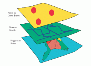
Figure 1. Example of GIS layers used in crime mapping.
GIS Application 2: Disaster Management
Another way GIS is used in society is in disaster management. GIS technology helps to identify and map areas that are at risk of natural disasters such as floods and other hazards. By combining different types of data, GIS can highlight vulnerable regions and support planners in making decisions about resource allocation and emergency preparedness. Tools like flood simulation and vulnerability mapping allow officials to see where risks are highest and plan ways to protect communities before disasters occur.
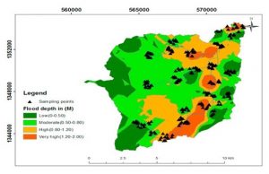
Figure 2. Example of flood risk modeling using GIS to show varying flood depths across an area.
Sources:
GIS Navigator. (n.d.). Disaster management. https://gisnavigator.co.uk/disaster-management/
Office for Victims of Crime. (2003). Crime Mapping. https://ovc.ojp.gov/sites/g/files/xyckuh226/files/pubs/OVC_Archives/reports/geoinfosys2003/cm3.html
Schuurman, N. (2004). GIS: A short introduction (Chapter 1). Blackwell Publishing. https://sites.owu.edu/geog-191/wp-content/uploads/sites/208/2022/10/schuurman_gis_a_short_intro_ch_1.pdf