Hello my name is Jack Payne, I am a senior here who is hopefully graduating in the spring! I am a business management major with a environmental studies minor with more of my personal interests laying in the envs minor. I am from Clintonville in Columbus, Ohio and have lived there my whole life but I have traveled a good bit through school to Italy, Patagonia in Chile, and out west on backpacking trips. Im excited for this class so I can learn the skills necessary to understand and use GIS incase it ends up being something I use in my post grad years.
Schuurman Chapter 1
I found this reading very engaging and insightful into the history and development of GIS programming. I have little to no prior experience with GIS and so my initial understanding of it was that it was used as a mapping software to create physical maps that represented various data inputs for geography and similar fields of study. However, from reading this chapter I now know it is so much more than just this. I liked that the author gave much of the theoretical processes behind why GIS came to be and what struggles and innovations allowed for GIS to evolve from hand done cartography which helped me understand why and how GIS software should be used. I learned that GIS software alone is not a one stop shop for theoretical problem solving but rather a tool to pair with human understanding of all the other nuances that affect a given issue. I also learned that GIS has an almost infinite amount of applications in our life, with the most interesting to me being its uses in agricultural transportation mapping as I would never imagine this being an application of GIS. I feel that the author in this chapter clarifies a lot of confusing topics about what GIS is effective for and what it should be used for and draws a sort of framework for its capabilities of data representation. The examples of GIS’ implications in farming are good examples of this as it shows many small areas where GIS can help such as identifying areas of a field that are not growing, but it has its limitations in these applications too which often is the point when human understanding and problem solving comes in to create a solution. Overall I found that this chapter gave me a very strong baseline understanding of what GIS is and how it can be used which will be crucial for this class.
The first application of GIS I looked into was its use in Paris during Covid to create a “15 minute city” bike network that allows people in the city to have safe bike transport anywhere across the city. I personally have used this network and it is an amazing feat of urban transportation in a city with a massive population. GIS was used in this to over lay cycle path data with subway data and road ways to create a map that is fast, safe and effective for urban transportation via bike or scooter or other wheeled transportation.
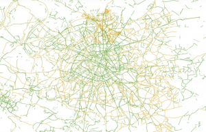
This image is slightly smaller than the one I found as I could not zoom out on the website to get the whole picture but this represents the bike ways overlayed with subway lines (https://www.apur.org/en/open-data-maps/open-data/cycling-facilities-paris-and-greater-paris#:~:text=By%202023%2C%20the%20metropolitan%20cycling,de%20rencontre%E2%80%9D%20and%20pedestrian%20areas.)
The second application I chose to look into was the use of GIS mapping in Patagonia to understand and help with wildlife movement, I chose this as I have worked with rewilidng chile and some of these things were things we talked about but GIS was never mentioned so I wanted to see how it was used. What I found is that GIS was used to help create the Ruta de los Parques which is a 1,700 miles of connected wilderness that spans across 17 national parks. This is a “route” that insures that wildlife that move across these areas can do so safely without reaching dead ends or man made blockages. I found this super interesting because some of our volunteer work we did in Patagonia was removing barbed wire fences from old farmers had put in place for livestock grazing which is now inhibiting the movement of native species that migrate from valley to valley such as the Guanacos. It is super cool to know that GIS mapping is almost like the over arching program used to put all these small plans into place to solve this issue.
(https://rewildology.com/chiles-route-of-parks-of-patagonia-how-1700-miles-of-connected-wilderness-is-revolutionizing-conservation/#:~:text=I%20had%20all%20these%20maps,way%20down%20to%20Cape%20Horn.) website used to get some of the genral info along with using meta to help me understand the application of GIS with this issue.
I also finished the quiz.