I am Henry Isaacs a Quantitative Economics and Data Analytics Major. I enjoy the outdoors and being on the water especially when I am fishing. I also play baseball here at OWU.
Schuurman Chapter 1:
With no prior knowledge on GIS, reading this chapter I quickly realized that it is far more than a mapping technology. What I took away most strongly is the idea that GIS creates dynamic maps that aren’t fixed on a page but can be queried, layered, updated, and reinterpreted depending on the question being asked. This flexibility makes GIS feel less like a static representation of the world and more like an analytical tool. You can zoom in, turn layers on and off, change classifications, or run spatial analyses, and each of those choices reshapes what the map reveals.
The chapter’s explanation of the two core data models, the vector and raster, also helped ground the technical side of GIS. Vector data, with its points, lines, and polygons, captures discrete features like buildings or roads, while raster data represents continuous surfaces such as elevation or temperature. Understanding these models made it clear why GIS is so versatile: it can represent both the things we can point to on a map and the environmental conditions that surround them.
Another major theme I took from the reading is that GIS is deeply shaped by human judgment. Decisions about what to map, how to classify data, where to draw boundaries, or which layers to include all reflect choices made by people. GIS isn’t neutral it contains assumptions, priorities, and sometimes power. This kind of surprised me because although most human generated things contain errors it seems they are hardly mentioned or don’t effect the final result very much.
Finally, the chapter highlights the wide range of applications, from environmental management to business logistics, or even emergency response. The idea that GIS can help responders identify evacuation routes, assess risk zones, or allocate resources shows how large of an impact this technology has that I hardly knew existed.
Overall, GIS is widely applicable and I am interested in learning more about it.
GIS Application 1:
https://ohiodnr.gov/business-and-industry/services-to-business-industry/gis-mapping-services/gis-mapping-services
Something that I am interested in and I found that GIS has a large application to is recreational fishing. I found a map given by the ODNR showing fishing depths and locations in Lake Erie around where I live.

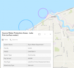
GIS Application 2:
https://www.arcgis.com/home/item.html?id=340969acd47a4e2ca70a24d1c8f32f0b
I also found that GIS can be used for inspecting water quality. I even found the area where the water I use at my house comes from. I could look at the quality of it and where that drinking water goes out to.
Quiz completed.