Personal: I am Natalia Ramirez, a commuter student from Columbus and a freshman at OWU. I am most likely majoring in Environmental Studies & Pre-law. As of right now, I plan to become an environmental lawyer to help improve the environment. I am new to GIS but I hope that it will help me improve my technology skills and my understanding of human impacts on the environment.

(I usually don’t wear glasses, but I was on a long flight)
Comments on Reading: After reading chapter 1 of the GIS textbook, I realized that there are many layers when it comes to GIScience and GISystems. Before reading, I only believed this system was only used by geographers to study rising sea levels or landscapes in general. It was interesting to learn how GIS is used by everyone. Such as a person using a GPS system to a business corporation analyzing its most popular location. While this is a useful tool, the chapter also mentioned the concern there is for GISystems since the data may be easy to misuse or misinterpret. Which is alarming since many common folk and scientists use this technology.
Throughout the chapter the main concern about GIS systems was finding an effective way to interpret the data. Mostly because there could be multiple ways to interpret it since the system may note the variable differently depending on the location. In my opinion, would it not be possible to create a system that could interpret the GIS results? Or would it create other questions? It may reduce other problems such as figuring out symbols needed to represent the spatial platform, or the best units for a GISystem.
Additionally, because GIS has various interpretations depending on locations, different countries may adapt it according to their geography. As the chapter mentions, Canada’s GIS compared to the UK or the US is different because of the developers, and geography. Nonetheless, the new GIS system may include everyone. Especially since the chapter mentioned how politicians need to analyze some areas to determine who receives benefits. After reading the chapter, I realized that there is much more to GIScience than what one would normally believe. I made connections to other topics such as philosophy, feminism, history, and art to help me understand the basis of GIS.
GIS Application: I personally have many interests but for the exploration I decided to do one in waste reduction and the other with polar bears. For the first source, I found an article that explains how to reduce waste in suburban areas. In this study, the researchers used GIS to track municipal waste and created effective management techniques to reduce it. On the contrary, they would analyze what waste management method was working if an area had low waste. This image explains the methodology used since there was no GIS map:
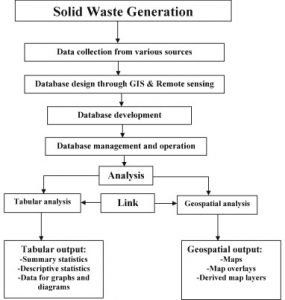
Source: GIS Municipal Waste Management
The second article used GIS to track polar bears in the Canadian Arctic in order to study their whereabouts as the Arctic is changing. The researchers specifically tracked where polar bear dens were and whether or not more conservation supplies should be enhanced. This form of GIS is important in order to conserve specialist species such as polar bears. This image is a GIS map of polar bears:
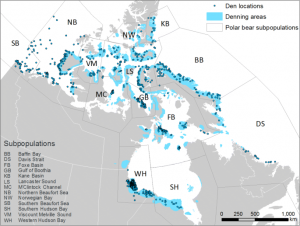
Source: GIS Polar Bear Den Tracking
Quiz: I have competed the quiz.