Introduction: My name is McKenna Downing, and I am a senior who is majoring in Zoology and minoring in Environmental Science. I am from Pleasant Hill, Ohio, which is 30 minutes north of Dayton. I am on the cross country and track and field teams as a distance runner. After graduation, I plan to find a job in wildlife rehabilitation and environmental education at a nature center (preferably somewhere warmer than Ohio). I am new to GIS but very interested in how it can affect many areas of science, especially in terms of deforestation and land loss.
Schuurman Chapter 1: Nadine Schuurman begins Chapter 1 by illustrating GIS as a large system, not a specific tool with a fixed or secure identity. Different companies or organizations use GIS for their specific jobs, and do not consider what others use it for. GIS dates back to the 1960s, when pieces of paper were layered on top of each other in order to find the best route for a highway. I think that’s really interesting because a problem that seemed difficult was made easy using a form of GIS. There were many people who were involved in the technology of GIS, such as Roger Tomlinson and Lee Pratt, who created the first computer cartography system to create a map of an area featuring all geographic features. I think that it is also interesting that GIS came around when it did, when information was being translated into technological terms and being distributed that way. The main way Schuurman tells us GIS was used in the early stages was to map data distributions, particularly within the environment. It makes me curious if these people would know how much of an effect it would have on the future! She then goes on to discuss how some GIS researchers perceive the system as a way to increase accessibility for spatial analysis. I think that’s really cool because there are so many professions in the world that can benefit from using this system. I also love the idea of GIScience and GIScientists. The classification of spatial entities can be difficult, because people can easily disagree on these parts. An example of this that Schuurman mentions is how to define where a mountain stops and the foothills begin. And it’s so cool that John Snow was able to use the concepts of GIS to figure out the cholera outbreak! I really liked how this chapter discussed how we use GIS in our daily lives, mostly without even realizing it. So many people use this system in different ways, and Schuurman wrote and described it very well.
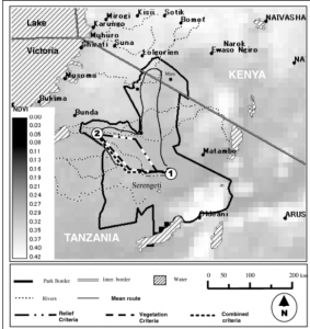
GIS Applications (1): Wildlife Migration: Understanding the migration of wildlife is incredibly important, and this research paper focused on how scientists used GIS mapping techniques to track the migration of wildebeest across the Serengeti-Mara habitat. The research included the mean routes of the wildebeest across the landscape and the amount of green space before and after the wildebeest had come through. The results found that the less green space in an area before the wildebeest arrived, the less likely they were to travel through that area because of the lack of water. Source: Musiega, D.E. and Kazadi, S.-N. (2004), Simulating the East African wildebeest migration patterns using GIS and remote sensing. African Journal of Ecology, 42: 355-362. https://doi.org/10.1111/j.1365-2028.2004.00538.x
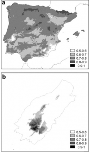
GIS Applications (2): Plant Conservation: This research paper focused on using GIS methods in order to implement plant restoration programs in Portugal. They focused on bryophytes and how they grew within a natural reserve with different species of vegetation, including alien species of plants, and varying levels of altitude. The researchers collected information from the reserve using aerial GIS mapping. it was found that the bryophytes all had differing levels of need within the reserve, with some doing well at altitude and others not. The alien species (invasives), also played a part, because they would grow quickly and outcompete the endangered bryophytes. GIS was helpful in finding these results, and is demonstrated in the map below. Source: https://www.sciencedirect.com/science/article/pii/S0006320703001253