Chapter 4:
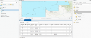
- Adding a folder through the catalog pane allows you to import data from that folder into your current project
- Older shape files can be converted to feature classes in order to fully utilize them in arcgis.
- Arcgis allows you to selectively create, modify or delete fields within a features data table and use python expressions to manipulate the data held within them.
- Joining data tables together allows you to select only the data you need for your application from a much larger set.
- Sums, averages, concatenations and many other operations can all be completed on data fields using Python expressions.
- Using SQL queries, data can be sorted through to find only the information relevant to your search by using search terms along with boolean operators.
- Spatial joins allow you to count the number of a feature within a bounding region and output it to a new layer.
Chapter 5:
- Since the earth is a sphere, but maps are usually displayed on a 2D surface, various map projections are used to translate the 3D surface onto a 2D one, with various drawbacks and advantages to each
- The Robinson Projection is best for general uses where the whole earth needs to be shown
- The larger the region you are trying to display, the larger the amount of distortion that the map will have, no matter the projection used
- Shapefiles are a common data type used for vector data in GIS software.
- Spatial data can often be found and downloaded for free on the internet, allowing you to select only the data you need for your project.
- Living Atlas gives you access to large quantities of geospatial data that you can download directly into your current project through the add data button
Chapter 6:
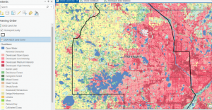
- GIS allows you to aggregate data by dissolving or combining finer groups into more general ones
- You can clip a larger map down to a single region to more closely match the focus of your project
- You can append data sets together to create a single larger feature class
- The union tool lets you combine two polygon feature layers into a single output layer