CHAP 4:
- Works with spatial databases and databases in general
- You can open folder connections in the right click menu under folders, which will let you access the files without having to locate them every time
- there is a geoprocessing tool which can make a shapefile into features called “Export Features”
- Databases can be inputted from .csv files and be made copied and such in the catalog tab
- You can populate fields with the Calculate Field tool
- GIS synthaxing is in python script
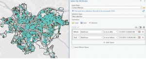
- Attribute queries help one search database information
- The Spatial Join tool is cool and useful
CHAP 5:
- The grid on the first map is called a graticule and is 30 degrees intervals
- You can add projects to a spatial map – whats the difference between a projection and a bookmark?
- You can look up the coordinate system of the USA on ArcGIS’s living atlas- what coordinate systems would I need to know for the rest of the world?
- You can download census data to use for GIS projects pretty easily on the gov’s website and other stuff on living atlas
CHAP 6:
- You can use the dissolve block group to separate blocks into specific neighborhoods
- You can clip attributes to areas to better study a specific area
- You can intersect features