Hi! My name is Sky. I’m from right here in Delaware and I’m a junior majoring in Environmental Studies.
Yes, I know my submission is late.. I was having major technical difficulties :/

After going over both the quiz and reading, it made me realize how much about GIS I really didn’t know. I’m coming into this class not knowing much at all about GIS systems and what they are capable of. One thing I thought was really interesting was how widespread GIS is. It isn’t something that is specific to one major or one group of people, GIS is open to really anyone (like how it can be used for police officers, students, and even starbucks shops). The reading goes over mostly history (dating back all the way to the 1960s) and the understanding/role of GIS systems. The reading was intended to demonstrate how GIS can fit into normal day tasks for a wide range of people. It’s really intriguing that coincidentally, the start of GIS actually didn’t involve computers. This is weird to think about because our world pretty much revolves around technology. The two different “faces” of GIS I think is something important to think about and that GIScience is basically the underlying theory of GISystems. GIS has more to it than just data and maps so I’m excited to get to learn more about it and what I could use it for.
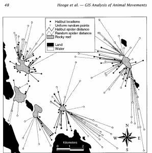
One of the GIS applications that I found and thought was really interesting was the use of GIS to track animal movements in marine environments. The reading goes over a bit about how GIS tracking isn’t used within water ecosystems as much as terrestrial areas. They kind of combined general GIS software with analysis tools that are specific to animal movement. There are a bunch of different functions that the paper goes over as well to show what types of animal movements and other things you can get out of using the software. The reason that studying animal movement is so important is because it can help with a lot of different research including fishing management, migration, and habitat management. The figure goes over location of the halibut being studied between different areas like pacific locations, rocky locations, and just randomly selected areas. I liked reading over this study and think that any of them having to do with tracking animals and their habitats is fun and interesting.
Source: Hooge, P. N., Eichenlaub, W. M., & Solomon, E. K. (2001). Using GIS to analyze animal movements in the marine environment(pp. 37–51). http://www.bio.davidson.edu/people/midorcas/GISclass/GISprojects/hartman/Anim_Mov_UseMe.pdf