Hello! My name is Ava Johnson, and I am a senior majoring in East Asian Studies. I have no computer science or environmental sciences major or minor . I just had a fun time taking the second module of this course a year ago and figured I would do it again, just in reverse order!


Here are two pictures of me because I thought the first one was hilarious. My friends that I had made while studying abroad in Japan and we decided to go on a 3am convenience store run, just because. Second picture is me in my dorm residence bathroom (was a great place for selfies lol).
Taking this course after taking the second module first a year ago is a bit entertaining and funny to me now that I really think about it. Having said that, it was interesting reading the first chapter, along with taking the syllabus quiz, as I began reflecting on everything I have already learned and applying that to this course as well. Starting off, the chapter was pretty straightforward in terms of a clear and concise introduction of the overview of the history of GIS and the different transformations it has made over the years. As I learned last year, yet still touched upon in this chapter, GIS is a lot more than maps or charts, and can allow for creativity to run wild once you truly become comfortable with the applications and layers. It was really cool to see so many large corporations, businesses and even states, counties and cities that utilize GIS in different ways. For example, here in Delaware, OH, different snow and ice area priorities are mapped using functions on GIS, along with climate patterns in completely separate areas around the world.
Application 1: I wanted to look at the different areas in Delaware, OH, where snow and ice removal have higher priorities as everyone can become more agitated once snowfall occurs with either how quickly or rather, not quick enough, snow removal comes through in different areas.
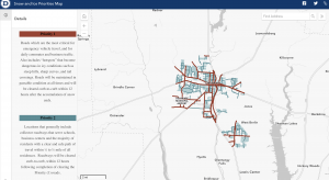
https://codgis.maps.arcgis.com/apps/instant/minimalist/index.html?appid=6e24626fa5544073b7d93b2676ce1aac
Application 2: I took a look at World BioClimates that factored influence of distribution of plants and animals
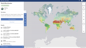
https://climate-arcgis-content.hub.arcgis.com/datasets/5826b14592ab4ebc99574919165bd860/explore?location=0.017175%2C0.000000%2C1.69