Address Point: Represents all certified addresses with daily updates and monthly publications.
Annexation: Covering changes from 1853 to the present and is updated as needed after official recordings and published monthly.
Building Outline: Consists of building outlines for all structures in Delaware County and is updated on an as-needed basis (last updated in 2023).
Condo: Includes all condominium polygons.
Dedicated ROW: Contains all designated road right-of-way lines and polygons and is updated daily and published monthly.
Delaware County Contours: 2018 two foot contours in File Geodatabase format.
Delaware County E911 Data: Utilizes certified address state to reverse geocode a set of coordinates and aid in emergency response. Updates are daily and publications are monthly.
Farm Lot: All farm lots within the US Military and Virginia Military Survey Districts and is updated as needed based on new recorded surveys.
GPS: Consists of GPS monuments that were established in 1991 and 1997 and is updated on an as-needed basis with monthly publications.
Hydrology: All major waterways and is updated on an as-needed basis with monthly publications.
MSAG: Defines the boundaries of the 28 political jurisdictions in Delaware County including townships, cities, and villages. Updates are as needed and published monthly.
Map Sheets: Includes all map sheets.
Municipality: Includes all municipalities.
Original Township: The original boundaries of the townships in Delaware County before tax district changes affected their shapes.
PLSS: Consists of the Public Land Survey System polygons within the US Military and Virginia Military Survey Districts and is updated as needed based on new surveys and published monthly.
Parcel: All parcel boundaries and integrates recorded document changes. Updates are daily with monthly publications.
Precinct: All voting Precincts. Updates are on an as needed basis and are published as needed by the Delaware County Board of Elections.
Recorded Document: Represents recorded documents from the Delaware County Recorder’s Plat Books, Cabinet/Slides, and Instruments Records, including vacations, surveys, and annexations. Updates are weekly and published monthly.
School District: All School Districts within Delaware County. Updates are as-needed and published monthly.
Street Centerline: Depicts the center of public and private roads and is updated daily with monthly publications.
Subdivision: All subdivisions and condos recorded and are updated on a daily basis with monthly publications.
Survey: Represents land surveys stored in the Recorder’s office and Map Department and is updated daily with monthly publications.
Tax District: Consists of all tax districts within Delaware County. Updates are on an as-needed basis and published monthly.
Township: Includes the 19 different townships that make up Delaware County and is updated on an as-needed basis with monthly publications.
Zipcode: All zip codes within Delaware County. Updates are on an as-needed basis through coordination with the United States Postal Service and published monthly.
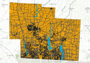
Parcel, Street Centerline, Hydrology – Delaware County