Powell Week 5

Chapter 4: File Geodatabases

I found Chapter 4 to be easy as it focused on how to import data into geodatabases and how to create different queries.Ā  This chapter focused on data how it can be used to modify the attribute tables in ARCGIS which you then are able to calculate and create different queries to get the information you need for new fields that you create for the attribute table.Ā  Overall this chapter was straightforward and easy to follow and I didn’t run into any issues.

Chapter 5: Spatial Data

I found Chapter 5 to be the most time consuming chapter.Ā  This chapter looked at map projections, coordinate systems, and looking at and working with US Census Bureau spatial and tubular data.Ā  This chapter started off easy and I found doing the map projections to be simple and fun.Ā  Changing a map’s coordinate system was also easy and I found the first half of the tutorials for this chapter to be very straightforward and easy to follow.Ā  Likewise working with the US Census Bureau data was also easy to follow and this chapter also showed how to join data and create choropleth maps.Ā  Creating the choropleth maps was easy but time consuming as there were a lot of different factors to take into consideration and I somehow managed to spend a good amount of time on tutorial 5 of chapter 5.Ā  The rest of the chapter was easy.

Chapter 6: Geoprocessing

Chapter 6 was very easy to follow through.Ā  I don’t really have any comments on this chapter as it focused on different geoprocessing features and how to edit and change them.Ā  Overall very simple and easy.

Chapter 7: Digitizing

Chapter 7 was really fun to go through as it looked at editing and changing polygon features and learning how to use cartography tools.Ā  Moving the features and using the different edit tools was very easy and fun to do.Ā  I also found it interesting the different cartography tools and how it is able to smooth out various polygons that represent land and water.Ā  The final tutorial of this chapter was the most interesting as it showed how to transform polygons.

Chapter 8: Geocoding

Chapter 8 looked into geocoding and I ran into an issue with the collect events tool as I could not get it to work.Ā  This chapter was very short and so it was the least time consuming and was very straightforward with the instructions.

Flores Week 5

I came to some problems in Chapter 4-2. When I was getting the data for tracts from the field view, I only had 1 piece of data for the tracts information. I tried restarting the file since I hadn’t saved it and maybe deleted the data, but when I restarted it, it was still the same. I kept going back through my steps to figure out what was wrong but nothing would change the outcome of the data. I kept moving on and then when I tried to make a new field ā€œpopyouthunder20ā€ it wouldn’t let me save, so then it wouldn’t add it to the Maricopa table. I had to skip the rest of 4-2 because I wasn’t able to do any of the steps because my file was all screwed up and probably corrupted. In 4-3 I would move the map and the colors would be dark red and green but as soon as I let go of the map it turns into a cyan blue.Ā 

In chapter 5 I really enjoyed going back to the basics and just exploring the different map projections to learn them and get familiar with them. It was cool going to the National map website to input information into arcGIS.Ā 

Chapter 6 was fairly simple, the tutorials were short and continued from the last tutorials helping you remember what you just did and using it for the next tutorial.Ā 

The start of chapter 7 was really fun, I liked editing the map and changing where the building polygons were to match the buildings. My construction toolbar didn’t show up automatically so it was hard to find it. It was fun creating the perimeters to label the buildings, it reminded me of like the OWU map and how they created it. In the last tutorial of chapter 7 my HBH1 layer was slanted and not aligned with Hamburg Hall, but I went back and retraced my steps and was able to fix it which felt very rewarding.Ā 

In chapter 8, when I tried to run the Collect Events tool it kept failing, so I had to skip it. Other than that, learning about the geocoding process was very smooth.

Fondran Week 5

This section was harder and more complex than the previous assignment.Ā  I ran into a few problems where I don’t think my final maps were correct but I tried my best to work through them.

Chapter 4:

The first tutorial in chapter 4 focused on importing data into a new ArcGIS pro project. At first, this was easy but soon I realized I had messed up somewhere. I realized that I missed the your turn portion and was completely lost when the second half was talking about tracts. I did not realize this until I had already left the lab and thought that it must have been a problem within the program. Comparatively to last week’s assignment I felt like I didn’t fully understand the work I was doing in some of the tutorials and was really just following along with what the book said. I understood that different tools helped find different results but I wasn’t really exactly able to understand how they were doing that work.

Chapter 5:

Chapter 5 begin by working with world map projections. It taught us how to change the given map into a different type of projection such as the Albers equal area projection. In tutorial 5-3 we worked on setting projected coordinate systems. It was mentioned that there are many ways for setting a maps coordinate system and regardless to the coordinate system apply you can always change it in the map properties menu. I enjoyed tutorial 5-6 about downloading geospatial data from the USGS National map viewer. I found it interesting that we can download data and input it into our own ArcGis program. I encountered a problem while trying to download the correct document as it was not working. I tried various methods to extract the contents from the downloaded file and then put it into the program but it was just not working. So I was unable to complete this tutorial. I still read through the tutorial and have a general understanding of what I was going to have to do.

Chapter 6:

Chapter 6 started off with a tutorial about dissolving features to create neighborhoods and fire divisions and battalions. We used skills we had learned in the first part such as opening attribute table and sorting different fields. We learned about the pairwise dissolved tool and what it is used for. We learned how to merge features and created a new NYC water layer that included all of the water features into one. I found this chapter to be less intriguing than others that I have completed.

Chapter 7:

Chapter 7 was the most fun tutorial chapter for me during this section I liked being able to actually move things around on the map rather than just him putting data into different tools like the last couple tutorials. It was fun putting the correct shapes of buildings back where they’re supposed to be and learning how to rotate them and change their size. Learning how to use the vertex points was a little bit of a struggle at first but I understood it after messing around with it for a little bit. We learned how to smooth a green space polygon. The result was a new feature class of smooth polygons for the golf courses. Tutorial 7-4 was a little bit harder than the last few. I had trouble transforming my building to fit into the smaller shape. I had to redo this step multiple times for it to finally work.

Chapter 8:

Chapter 8 was the easiest set of tutorials I’ve done so far because there was only two. It started off strong and I was able to complete tutorial one. However in tutorial two I ran into a problem when trying to use the create locator tool. I tried putting in the correct settings and running it multiple times without being able to get it to work. I attached a picture of what it looked like I am not sure what else I could have done.

BANTI WEEK 5

Chapter 4

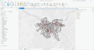
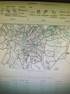
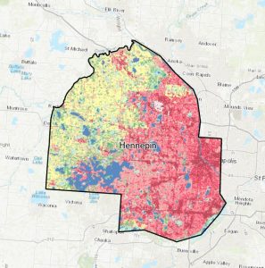
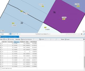
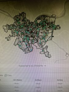
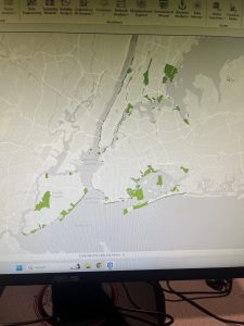
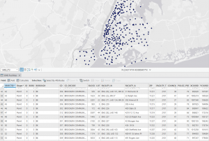
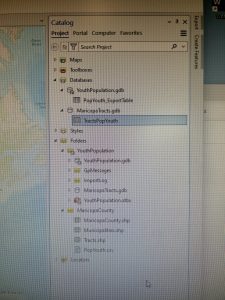
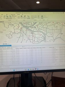
This unit was more difficult as the instructions didn’t involve much detail, and I had to remember many procedures from previous chapters. In Tutorial 4-1, I created a new ArcGIS Pro project named “YouthPopulation” and connected external folders, allowing access to spatial data. Converting shapefiles to feature classes reinforced the importance of proper file organization. Tutorial 4-2 involved modifying attribute tables, deleting unnecessary columns, and renaming fields, but I accidentally skipped the “Your Turn” section, which required creating the Tract feature class. This mistake forced me to redo the tutorial, reinforcing the importance of completing all exercises. In Tutorial 4-3, the SQL syntax was challenging, but ArcGIS Pro’s query builder helped. Tutorial 4-4 introduced spatial joins to aggregate burglaries by neighborhood, emphasizing data organization. In Tutorial 4-5, I learned how to create central points from polygons using the “Feature to Point” tool and the “Calculate Geometry” tool to add coordinates. The distinction between centroids and central points was particularly useful. Tutorials 4-6 covered creating a code table for crime hierarchy codes and performing a one-to-many join for better data representation. Managing these joins and understanding the limitations of large datasets were key takeaways. Ā 

Chapter 5

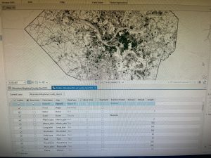
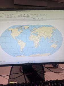
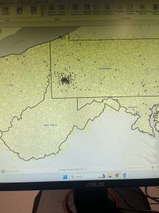
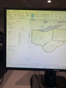
This chapter focused on projections, coordinate systems, and working with U.S. Census data, making it a more technical and detail-oriented unit.. Tutorial 5-2 highlighted the importance of selecting the correct coordinate system early on, as it impacts later analyses. Working with external geospatial data and understanding how different formats interact with ArcGIS Pro was a valuable experience,Ā  the need for precision in GIS workflows was proved to me again from this chapter. By the end of the chapter, I had a stronger understanding of how projections influence spatial accuracy and how to effectively prepare datasets for mapping and analysis. This unit served as a great reminder of how foundational GIS concepts come together in practical applications.

Chapter 6

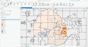
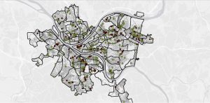
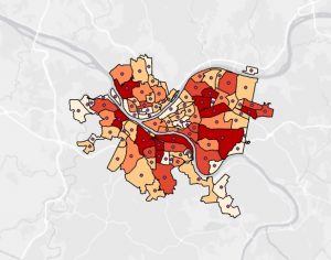
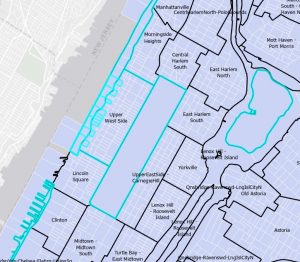
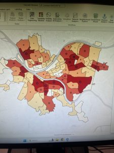
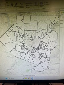
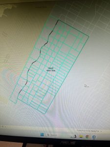
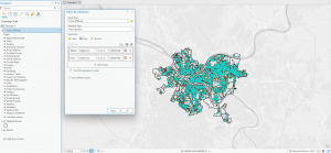
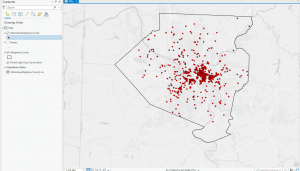
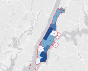
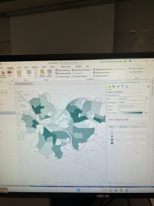
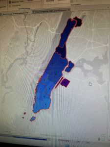
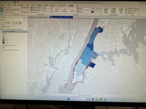
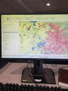
Chapter 6 focused on geoprocessing techniques such as dissolving features, extracting and clipping study areas, and merging layers,Ā  for mapping fire company zones in Manhattan. A key task involved using the Pairwise Dissolve tool to group fire companies into battalions. In the beginning, I didn’t understand what the point of this tool was, after using it and experimenting for a bit I got what it is about. Fire battalions were symbolized using graduated colors to represent population density. Using graduated colors gave useful information to the map, and the different densities are easy to tell apart with this feature. Labeling the fire battalions was the most challenging part, as it required working with label properties to ensure the names and numbers were displayed correctly without cluttering the map and making it hard to read.Ā 

Chapter 7

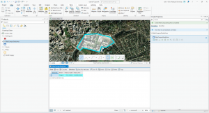
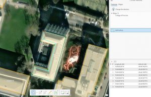
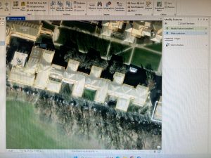
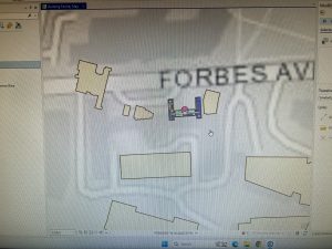
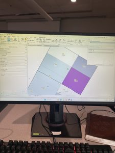
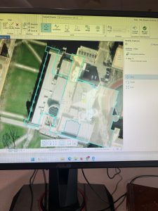
Chapter 7 introduced digitizing techniques, focusing on editing, creating, and transforming polygon features in ArcGIS Pro. This unit involved various tools and methods to manipulate spatial data, such as modifying existing polygon features, adding new ones. One of the key things I learned was working with tools that enhance the visual representation of geographic features, along with spatial transformations. A particularly challenging part was figuring out how to use the Split tool effectively, as it required precision in dividing features correctly while maintaining the integrity of the dataset. Unlike previous chapters, this unit required a more direct interaction with the features rather than simply applying geoprocessing tools. The experience was engaging and I liked it.

Chapter 8

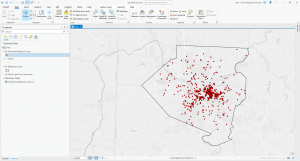
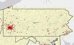
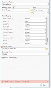
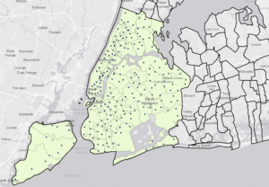
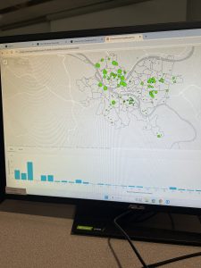
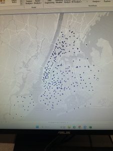
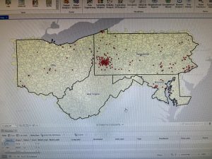
Chapter 8 introduced geocoding, which focused on converting addresses and zip codes into mappable points, making it one of the more practical and engaging topics so far. This unit involved working with both zip codes and street addresses to analyze spatial data, which was interesting because it showed how location-based information can be transformed into meaningful insights. I found the process of matching addresses to locations straightforward, especially after getting used to ArcGIS Pro’s handling of data inconsistencies. Unlike previous chapters, nothing in this unit felt overwhelmingly difficult—I’ve started to adjust to the workflow and feel more comfortable navigating the tools. The matching techniques for improving address accuracy were particularly useful, and it was satisfying to see how geocoding could be applied to real-world scenarios, like analyzing event attendance based on survey data. Overall, this chapter reinforced how GIS can make spatial data more practical and accessible, and it felt like a natural progression in applying everything I’ve learned so far.

Hickman Week 5

Chapter 4:

As I started tutorial 1, the Tracts feature under youth population in the catalog pane was not appearing. As I could not find the Tracts feature, I also cannot do tutorial 2 in Chapter 4 as it requires the tracts feature… I, however, can start on Tutorial 3. In tutorial 3, I was supposed to get 444 remaining, but I got 430. In tutorial 4, I was very easily able to complete it. I liked when I was able to add color at the end for the choropleth map.


Chapter 5:

I liked being able to see the globe in a different perspective. In tutorial 3, I had trouble finding the “NAD 1983 UTM Zone 11N”. It was in a different spot than what the book referred me to. I ended up finding it however. My favorite part of this chapter was adding another baselayer. It is cool to see the different parts of areas.


Chapter 6:

Chapter 6 was the easiest for me. I liked being able to see just the specific parts of areas. Here are a few pictures of what I got.


Chapter 7:

This chapter was fun. I went crazy fixing all the building polygons. It was lowkey driving me insane that they were all a bit off.


Chapter 8:

I was a bit confused with this chapter, but I got a bit of it understood, like the first part.

Kocel, Week 5

Chapter 4Ā 

Chapter 4 was a lot of work with spatial databases and databases in general. The first part was straightforward and I got it pretty easy. However, tutorial 4-2 I ran into some problems. When trying to code GEOIDNum = !GEOID10! I kept getting error messages which took me to a webpage with a message from python saying the code was invalid. I’m not very tech savvy but I tried my best to figure it out. Eventually I had to move on from this section.Ā  Moving on, section 4-3 was interesting. This section was about carrying out attribute queries. I was a little intimidated at first seeing what looked like lines of code in the book, but it was not that bad. Below is a picture from 4-3 with data from crime incidents.


Chapter 5Ā 

This chapter was really interesting. I was happy to go back to working more with the shape of maps. The first section was fun. I was given a map of the world but with some distortions. Then I had to change the map projection to the Robinson projection, which is usually used when mapping the globe.Ā  Below is a picture of that map in 5-1. Tutorial 5-2 was pretty straightforward. I ran into some trouble in 5-3. Everything was going smoothly, I added tracts and municipalities to the map, added tracts and layers and changed the outline color, so it was pretty basic stuff. Then I needed to change the coordinate system. There was no NAD 1983 so I could not finish this part of the tutorial. This chapter ends with working with real world data, which I thought was really cool. I like how I went to the actual US census website to use real data. However, I ran into yet another problem trying to finish this chapter. I could not figure out how to access the data to put into Microsoft excel. Downloading geospatial data seems like It will be important so I plan on going back to this part later.


Chapter 6Ā 

This chapter was all about geoprocessing. 6-1 was pretty easy. I learned how to dissolve features to create neighborhoods and fire divisions and battalions. This is important for real world applications. I did not have the chapter 6 gdb so I could not export the selected features for part 6-2. I really liked 6-3 when I had to merge water features. Tutorial 6-4 was very simple and it was nice to have something easy. I simply imported two files and ran one of the tools. I will provide a picture of the data from 6-4 below. The last two sections were a little more tedious in my opinion. I am still not super confident when it comes to things like combining two sets of data.


Chapter 7Ā 

I really liked this chapter. I appreciate any part of a chapter that does not require a lot of data input, and this first part was moving buildings to their correct locations. This was my favorite part, it was like a game being able to move all the buildings around. Below I will add a picture from 7-1 of moving the first building. The rest of the chapter had similar tasks using other cartography tools.


Chapter 8Ā 

I was very pleased to see how short chapter 8 would be. This chapter is about geocoding. The first part is geocoding data using zip codes. I had to build a zip code locator, and then correct the unmatched zip codes. This part was challenging for me because at this point my brain was tired and ready to be done with GIS. But, I prevailed. The second part was really easy. 8-2 was about geocoding street addresses. I will provide a screenshot of the finished map from 8-2 below. First I built a street locator and set its geocoding option. Putting in all the data in the create locator pane was a little tedious, but very straightforward. Overall, I understood chapter 8 pretty well.

Counahan Week 5

Chapter 4:

Chapter 4 was much easier to work through compared to the earlier sections. Importing data wasn’t too hard, but it did take some patience. Even though the process took a little time, I can tell that repeating these steps is helping me get better. One of the biggest improvements I’ve noticed is how much faster I can navigate ArcGIS Pro. I don’t have to waste time looking for tools like the Catalog Pane or the Toolbox—they’re starting to feel natural. It’s great to see that practice is making everything smoother. Some steps felt a little repetitive, but I know they’re helping me build a strong foundation for harder tasks later.

Chapter 5:

Chapter 5 really opened my eyes to how world map projections work. I never realized there were so many different ways to project a map, and it was cool to see how state shapes and sizes change depending on which one is used. This helped me understand how map distortion happens and why it’s important to pick the right projection. The chapter made me think about how different projections affect the way we see and use maps.

Chapter 6:

Chapter 6 was all about making a neighborhood map, which was fun and useful. One of the best parts was working with fire department and police station layers—it was interesting to see how these important services are mapped in a community. Being able to look at and adjust these layers made the activity feel more real, not just like a regular assignment. This chapter showed me how GIS helps with city planning and keeping people safe, which made it feel more important.

Chapter 7:

Chapter 7 was definitely the most fun and interesting so far. I really enjoyed using different tools to create maps—it felt both creative and useful. The hands-on practice helped me understand the concepts better than just reading about them. But I still have some questions. Iknow how to use the tools now, but I’m not sure when to use each one. How do I decide which tool is best for a certain task? What happens if I pick the wrong one?

Chapter 8:

Chapter 8 was pretty simple and went by quickly. In section 8-1, I had a little trouble finding some buttons at first, but after looking around, I figured it out. Section 8-2 was even easier—I didn’t run into any big problems, and the steps made sense. It was nice to go through a chapter that was straightforward and reinforced my skills without being too difficult

.

Week 5 Fry

Chapter 3: I began by finishing the remaining tutorials for this section learning how to integrate with aspects of the online GIS system which was very interesting. I unfortunately could not get my maps to share with the online program, so to accomplish these tutorials I had to use maps already shared by classmates. However, I was able to accomplish and create all the other features on my own within the web system.

Chapter 4: The first two tutorials were interesting because I had to start from scratch and open a project with the regularly set base layers and build from there using database information in the esri folders. It was really helpful to learn how to do this, and I felt like I got much closer to actually being able to create a whole map from scratch on my own, which is obviously one of my goals in taking this course. While doing the third tutorial I was able to save and import the definition query but it would not appear in the mapping system again. I could not find what error was occurring so I moved on to the other queries in the chapter, which will definitely prove helpful in the future when working with large datasets and trying to understand different variables. Tutorial four was quick, it reminded me of how to create a map using simple data and graduated colors, it was pretty basic but at the very least made me feel accomplished. The next tutorial was pretty similar, I just had to add graduated symbols to the map which was a refresher but I was able to accomplish this with no issues. Finally, in tutorial 6 I was able to join the crime type data and manipulate the symbols to make data visualization easier.


Chapter 5: The first tutorial taught me how to change the type of distortion that is used in a 2D map of the world in GIS to be useful for different regions and have different rates of distortion. The second tutorial was the same but exclusively for the United States. Tutorial 3 was useful to learn more about how to use the coordinate systems within the maps and changing and manipulating the the coordinate system of a map. For the fourth tutorial, I was not able to locate the data file within the chapter 5 folder, it was not a part of my initial esripress download which is stored on my external hard drive. So I moved on to the fifth tutorial, which I spent a ridiculous amount of time extracting data from the US Census Bureau, but eventually found the proper way to integrate it all into the map. Finally, I moved on to the 6th tutorial, which involved adding even more data on things like bike stations into this map.


Chapter 6: I began with creating the map of New York City fire battalions which taught me how to dissolve and merge boundaries within the data of the map. I found this very interesting and I was able to execute all the actions without too much issue. Next, I used the instructions in tutorial 2 to clip the streets in the Upper West Side which was relatively simple. Then, tutorial 3 had me merge all the water features in the area of Manhattan. Tutorial 4 taught me how to merge two datasets into one with the police and fire stations of New York. Tutorial 5 was useful to find intersecting features which in this example were the streets of Manhattan and their fire companies. Tutorial 6 was all about calculating and comparing geometric attributes of the mapping data which in this case was the landuse of Brooklyn. Finally, tutorial 7 was useful to learn more ways to analyze counts of data within regions in this case the amount of people with disabilities within a fire companies jurisdiction. Overall this chapter was the smoothest one I’ve completed so far, and I actually remembered to take some pictures while I was doing it.

Naples – Week 5

Chapter 4

With the first tutorial (Tutorial 4-1), I was immediately stumped. It was going well, until I reached the portion with the subheading Use database utilities in the Catalog pane. The tutorial asks the user to copy the Tracts feature class from YouthPopulation.gdb. There was no Tracts feature class under the YouthPopulation.gdb Database! I eventually figured out that I have the file in one of the folders with content on my hard drive. After this I imported the feature class into the database it should have been in. I copied the feature class to the MaricopaTracts database and continued on with my tutorials. During Tutorial 4-2 I ran into an issue with the instructions in the textbook. Under the Add a field and populate it using the Calculate Field tool I kept getting an error message. Step 7 tells the user ā€œIn the Calculate Field pane, double click GEOID in the Fields panel to create the expression GEOIDNum = !GEOID10!. However, When I did this I received an error message and the values of the GEOIDNum column remained completely empty. I figured out that writing the expression ā€œGEOIDNum = !GEOID!ā€ got my data entered correctly. I’m not sure as to why it was written differently than it functions. Nonetheless, I carried on. Overall I had an enjoyable time going through Chapter 4. My main mishaps that I ran into were very minor. I would click the wrong button, open the wrong pane, etc.

Chapter 5

Going into chapter 5 I was pleasantly surprised that there was such a basic map in Tutorial 5-1. I have been missing looking at maps instead of filing through different panes editing information (although the editing information sections are obviously extremely important). Ā This pleasant surprise quickly turned into being stressed again (haha). My first issue had arisen in Tutorial 5-3. I was going to change the map of California’s coordinate system. When I opened the Map properties pane and navigated to Coordinate Systems, I was instructed to select NAD 1983. NAD 1983 was nowhere to be found. I searched through the different files that came with the tutorials to no avail. I eventually chose to move on to the next Tutorial. Everything prior to this in Tutorial 5-3 was great though! In Tutorial 5-5 the textbook instructed me to download official census data. This is something that I have been specifically waiting to see if it would instruct me where to access this data. Along with actually accessing the data itself, Tutorial 5-5 actually walks you through how to process this data in Microsoft Excel. I have some (using that very lightly) experience using Excel, so this explanation was very helpful. As two things can be true at once, this was also very overwhelming at times. Doing the (VERY) rough math, the Excel spreadsheet had over 450 columns of data. At times it felt like my head was spinning. However, again, it was very nice to see this data outside the curated tutorials from the textbook.


Chapter 6

Chapter 6 opened with Tutorial 6-1 focusing on Manhattan. The tutorial walks the user through how to use the Pairwise Dissolve tool. Using this tool, the textbook teaches the user how to create neighborhoods, or in this case Fire Battalions. The explanations and work for this first tutorial are pretty straightforward. I did not struggle on this first Tutorial. Tutorial 6-3 was so short and self explanatory that I honestly though I missed something. It walks you through the steps of merging feature classes in order to make one feature class with all of the previously separated feature classes’ data. It was so short that the photo given for the beginning is almost the entire length of the actual tutorial. Along with 6-3, Tutorial 6-4 was extremely simple. I imported two files and ran one of the tools. At least 6-3 had a ā€œYOUR TURNā€ section. Overall I thoroughly enjoyed Chapter 6. While it was challenging, It also felt like a ā€˜back to basics’ moment for a little bit as there was a lot of instruction regarding how to use tools with the maps, rather than staring at spreadsheets.


Chapter 7

Starting Chapter 7 with the first tutorial, I was kind of excited. The editing of polygon features is something that I have been looking forward to learning how to do. Sounds a little weird and nerdy when I type that out I guess. Although I was very interested in this portion of the software, this did not make it any easier for me to learn the ā€œEdit Verticesā€ tool. In fact, I was actually lost for more time than I’d like to admit. However, once I realized the Construction toolbar was sitting right in front of my face I moved on rather quickly. Everything was going perfectly fine until I got just barely before the end of Tutorial 7-2. I created the feature class for parking lots to add to the map of the campus. However, when I went to the edit tab to actually map out and create the parking lots I was greet by every feature class aside from the one I just created. There was an error message telling me that the layer was marked not editable. It said that you can control the editability ā€œin the List by Editing view of Contents pane.ā€ I tried clicking through everything to find a toggle once again to no avail. I decided to count my losses and move on. For the final Tutorial, 7-4, I ran into a weird issue. When importing the HBH1 file, the StudyAreaBldgs feature class got messed up somehow? I’m not 100% sure what happened but some of the buildings were moved and scaled down from where they were supposed to be on the map. I tried my best to fix it, however I ended up just transforming the building to the comically small outlined building.


Chapter 8

Chapter 8 felt very overwhelming. I’m not sure if I was running out of steam, if it was genuinely as challenging as it felt, or a mix of both. However, the amount of different panes that I had to go through to successfully complete the tutorials was intense. There was just so much to enter and make sure that these tools are running properly that I kept either second guessing myself, or actually entering things wrong which put me back more and more. However, one big issue that I wasn’t able to troubleshoot was with rematching the attendee data by zip code. The book told me to enter the zip code (15230) into the Rematch Addresses tool, however it was automatically entered. I also could not run the tool. I’m not sure what the deal was, however I went through all the motions that I was able to. lthough it felt like cruel and unusual punishment at times I do know that my skills will be better because I committed to doing these tutorials (as) properly (as I could).


Keckler Week 5

Chapter 4

Chapter 4 was about working with databases. It was a bit funny to me, though, how once all of the additions were made to the Maricopa Tracts geodatabase then the directions said to delete it. It also made me mad, but I think that deleting the Maricopa Tracts geodatabase messed with something because there were no tracts to be found when I was trying to complete the second tutorial of the chapter. After that blunder, I moved on to the next section about attribute queries which are building on the SQLs from the previous chapters. This went smoothly since it was review from before. First you change the symbology to count, and that is followed by writing out expressions. Expression writing was followed by spatial joins which connect sums of a certain feature to polygons on the map; in this case, the counts were burglaries, and the polygons were neighborhood boundaries. The final section was about creating an attribute table for the neighborhood burglaries followed by creating a point layer. After the bumpy beginning, my proverbial DesktopGIS road smoothed out for the remainder of this chapter.

Chapter 5

Moving on to Chapter 5, the preface of the first tutorial boasted how many coordinate systems and map projections are in ArcGIS Pro. The first task was to look at a distorted map projection of the world, then, to change the coordinate system to Hammer-Aitoff in order to remedy the distortions. Moving from the entire world to just the United States, the second section required playing around with the coordinate systems of the US to show the country through the Albers equal-area projection. The next section continued with changing the projections and coordinate systems according to different map scales while manipulating some symbologies along the way. Getting through the projections led to working with shapefiles which will be pertinent for using the Delaware Data for the final exams. Everything with this went according to plan. Then, next was working with the US Census data. This section was a bit tedious, but I had a chance for redemption for my failed choropleth map from Chapter 2.

Chapter 6

Halfway through Part 2, Chapter 6 was a bummer. The chapter started off well. Working with the Pairwise Dissolve tool was alright, and the rest of the first two sections were well. The third tutorial threw me off. I could not find the merge tool. I searched for it- exactly how I searched for everything else up until then, but I could not find the tool. I was either fogged by my influenza or fogged by the frigid temperatures of the Science Center freezing my peeper over, but I could not find the tool. Moving on from the disappointment of the previous section, I was back to the Pairwise tools, and everything was fine. I fabricated some inputs and outputs then commanded statistics of the Manhattan Fire Company, and I proceeded to the sixth section. Staying in New York, the next section was about the neighborhoods in Brooklyn. First was working with attribute tables again, using the Union tool, performing calculations using GIS, and then making some queries. After this section, I encountered an issue using the Tabulate Intersection tool. After inputting the data, it was not working properly. I tried again and encountered the same result, so I moved on.Ā 

Chapter 7

Moving and rotating the polygons in the first tutorial of Chapter 7 was fun. With that said, the process of saving the changed location of the polygons is inefficient. Each time I would click outside of the area to establish the new location of the polygon; it would move a bit. I feel like the apparent advanced nature of ArcGIS Pro would have a better way of keeping polygons in their proper positions- especially since they boast about the capabilities of their system. Besides my gripes, the movements were fun compared to the devastation of codes and the other minor things that have not worked properly for me. Exporting and moving the computer-aided design drawing was great; it was a nice reinforcement of what I had done before in the chapter, and it elaborated on other features in the program. The drawing looks like an overhead view of one of those spaceships from Star Wars, so that added an extra layer of whimsy to the GIS adventure.

Chapter 8

Chapter 8 was a heartbreaker. My geolocator code would not work. I tried to fix it, but it still would not work. This chapter was more difficult than the others for me because I kept messing up the inputs for the tools. I did manage to eventually make some of the tools work, but I ran into many roadblocks with the geocoding sections. I believe that I may have very bad luck, for I may not be meant to input simple data in ArcGIS Pro.