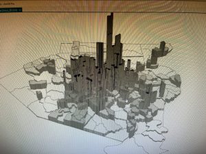
In chapter 1 I had some difficulties learning how the program worked but when I figured it out it felt very rewarding. I found arcGIS to be very inaccessible, they use very technical language that someone who doesn’t normally work with computers won’t understand. The textbook tutorial is also very vague with its instructions at times, but they are also helpful at certain points. The instructions are also outdated and not the latest version of the program. I liked learning about how to navigate the maps, and it was really cool learning how to change the maps from 2D to 3D. In Step 2 of Use a pop-up window, There was no website hyperlink for me to click and explore, so I couldn’t open that. I also forgot to save tutorial 1-3, which doesn’t affect me but now I don’t know how to get that back.
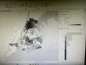
Chapter 2 I had an issue at the start of 2-2, the labeling and layer groups Weren’t working and wouldn’t show up on the map. Some of the instructions were telling you to do the same thing with different contents but explaining it in different ways which made it really confusing. I did like that it was New York and we used the same colors the New York City Planning department uses. It was interesting learning about choropleth maps and how they use color to represent numeric values, it makes it easier for a visual learner to understand the map and learn the information it is giving. This chapter really helped me understand how the maps work and helped me get more comfortable with the GIS application
In chapter 3 we learn the really important skill of transferring our maps off GIS and sharing them with people who don’t have access to it. The 3-3 tutorial was really cool because it was basically teaching you how to create a website. I struggled to find out how to place the table and the map side by side. I also didn’t have the pie chart from one of the steps, but it didn’t affect the dashboard.