- Hi! My name is Will White. I am a junior here at Ohio Wesleyan. I am a Business Management major and also a member of the Ohio Wesleyan’s Men’s Lacrosse team where I play goalie. I am from Pelham, New York which is right outside of New York City.

- Chapter 1 of Nadine Schuurman’s GIS: A Short Introduction outlines the growing significance of Geographic Information Systems (GIS) in modern life and its diverse applications across fields like urban planning, agriculture, epidemiology, and commerce. GIS’s ability to integrate spatial data and generate meaningful insights has made it indispensable, though its identity remains fluid and multifaceted. Schuurman highlights the dichotomy of GIS as both a technical tool (“GISystems”) and a broader field of inquiry (“GIScience”).One key takeaway is how GIS has evolved from simple computerized cartography to a sophisticated analytical tool. For example, it enables urban planners to visualize traffic impacts or epidemiologists to track disease outbreaks, emphasizing its capacity to combine spatial analysis with intuitive visualization. Schuurman also stresses how GIS has shaped daily life, from determining waste collection routes to optimizing retail locations like Starbucks. What stands out is the tension between the technical and philosophical aspects of GIS. While it excels in creating visually accessible data representations, the author argues that GIS users must understand the underlying assumptions and potential biases in data encoding and boundary definitions. For instance, how we classify spatial phenomena—such as community boundaries—can drastically affect analysis outcomes. Schuurman also touches on the collaborative and ethical dimensions of GIS, mentioning feminist perspectives and Public Participation GIS (PPGIS). These approaches seek to democratize GIS technology, emphasizing inclusivity and questioning whose interests GIS serves. Overall, this chapter provides a balanced introduction to GIS, celebrating its technical achievements while encouraging critical reflection on its societal impacts. It effectively sets the stage for readers to explore GIS’s complexities beyond its surface applications, prompting questions about its role in shaping how we interact with and interpret the world.
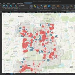
- GIS plays a crucial role in crime analysis by helping law enforcement visualize and understand crime patterns. Through mapping hotspots, it highlights areas with high crime concentrations, enabling targeted patrols and resource allocation. For example, police in Los Angeles have successfully reduced crime rates by focusing efforts on these mapped hotspots. Additionally, GIS supports predictive policing by analyzing historical data and environmental factors to forecast where crimes are likely to occur, allowing proactive measures to prevent incidents. A crime density map of Washington D.C. illustrates how GIS identifies areas with frequent incidents, guiding more effective strategies. Overall, GIS enhances crime prevention and contributes to building safer communities
https://www.esri.com/en-us/industries/law-enforcement/strategies/crime-analysis?utm_source