Hey, my name is Adam, I’m a freshman majoring in Neuroscience(maybe) and Pre-med(maybe). I love to read and my girlfriend. I took 292 last semester so I’m taking the courses in reverse!

Schuurman’s introduction is primarily concerning the history and applications of GIS. The former half, history, was so so so boring to me because I don’t really care about how GIS came to be. Regardless, I did learn some new terms that I find worth mentioning. First, it’s worth mentioning that GIS can stand for two different things: “Geographic Information Science” and “Geographic Information Systems.” To me, it seems that these terms can be used interchangeably, but it can be helpful to differentiate between the two. GISystems generally refers to the hardware and software that is used to represent geographic data, while GIScience refers to the study of how the systems work, are used, and impact society. The latter half was a bit more interesting to me. It was an interesting exploration of how pervasive GIS is in so many fields. In health fields, for example, we can use GIS to model the spread of diseases or analyze the access communities have to care.
Searches:
Search 1: First, because I like reading, I decided to look up “GIS libraries” and stumbled across an article by American Libraries Magazine. The article details how librarians are increasingly using GIS to enhance their services and provide resources. It speaks to how librarians have created digestible interactive maps to make complex information easier to understand for readers.

https://americanlibrariesmagazine.org/2021/09/01/on-the-map-gis-software/
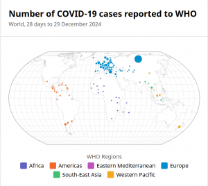
Search 2: In my second search, I decided to go in the direction of its use in disease control and awareness. I came across the World Health Organization’s website and found some of their data on COVID-19. On this page, there is a map that shows reported cases of COVID-19 globally.

https://data.who.int/dashboards/covid19/cases?n=c