Hello! My name is Emily Keckler. I am from Marengo, Ohio and this is my first year at OWU. My major is Environmental Studies, but I am considering a double-major with Geography. As a fun fact about me, I love cats and eating my vegetables!

The use of GIS under real-life circumstances is an interdisciplinary tool that can range throughout different subjects depending on the goals of the user. The tool can be used in multiple different ways and is changing alongside technological developments. However, the initial rise of GIS was underscored as making maps on computers instead of realizing the technological potential of analysis using GIS data. It is very fascinating to read how GIS was being developed in many different areas leading to the proliferation of Environmental Research Systems Inc (ESRI) which has a stronghold on GIS technology- even today. I do wonder, though, about the apparent contention behind the initialization of GIS; it seems like it would drain a lot of energy to debate on its roots when GIS clearly has roots in multiple areas. Why argue about something so menial in the grand scheme of GIS?
I also found the point about what the acronym “GIS” means to be particularly interesting. Some like GIS to be “Geographic Information Science” instead of “Systems” and vice versa. The differentiation seems arbitrary in that GIS- however it is defined- can be used in both ways that it is identified. Reading on, the lines between “science” and “systems” concerning GIS seemed to rapidly blur. It began to seem less like a meaningful differentiation and more like a power imbalance among what the technology is used for. It was also very comical that the section recognized the muddiness of the subject. Regardless, it seems that either “field” so-to-say can be employed to serve the role poorly distinguished through “GIScience” or “GISystems.”
Whichever way that it can be defined, GIS is critical to many functions in modern living. From transporting food from farms to grocery stores to delivering an Amazon package in two days, GIS can be used for almost anything.
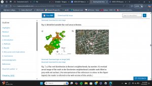
As an application area I looked up “Vegetable Garden GIS Applications” on Google Scholar where I found an assessment of the possibility for the rooftops of Boston, Massachusetts to be used for agriculture (Saha, et al. 2017). Using geospatial technology, researchers mapped out the numerous rooftops of Boston to determine their viability to be made into green space for produce yields, carbon sequestration, etc. (Saha, et al. 2017).

https://doi.org/10.1016/j.landurbplan.2017.04.015
For a second application I searched “Banana Farm GIS Applications” and this led me to an article from the Agrarian University of Ecuador concerning using GIS to optimize the process of fertilizing banana crops for nutrition standards (Duque, 2022). The use of GIS in this process allows for accurate control and monitoring of banana crops, soil quality, pest control, etc. (Duque, 2022)