Hi, my name is Gwendolyn Godsey, or Gwen for short, and I’m a senior majoring in Environmental Science with a minor in Nutrition.
While reading Chapter One of Nadine Schuurman’s GIS: A Short Introduction, I found it intriguing that the essential components of GIS, such as the concept of various layers of landscape (forests, streets, valleys), were mapped out using tracing paper and a light table. The tedious task of creating these layers and spatial analysis by hand can now be organized and separated quickly by computers, highlighting the advancement of the GIS process. GIS relies on a visual display of data and information, so it could be considered an unreliable or unscientific approach to quantifying data. However, as a visual learner, the illustrated display of information is easier to understand than viewing data on a table or chart. Before reading this chapter, I was unaware of the difference between GISystems, which focuses on the hardware and software that can capture and represent geographic information, and GIScience, which focuses on the abstract ideas behind the data and systems. As I understand it, GIScience is a foundation of ideas for how GISystems are built and operated, and the term GIS is used to describe both the system and the science behind it. Since the GIS process depends on spatial data, crisp and defined lines are favored in GIS to represent differences between various landscapes. I can understand why the classification process between landscapes and boundaries can become fuzzy, making this a challenge for users to overcome. The power of the GIS system is impressive, as the visualization of spatial relationships and objects allows the users to easily explore both intuitive and structured cofactors that may relate to an overarching pattern. Initially, I believed that GIS was only used by scientists and the government to understand environmental patterns or issues. But now I realize the true diversity of the industries that utilize GIS, including universities, hospitals, community groups, and public and private businesses.
One area of GIS application is in Feminist Geographic Information Sciences (FGIS). Where conventional GIS uses precise locational measurements to quantify space, feminist GIS uses location and social processes with concerns about equality, wealth distribution, and power allocation. Through GIS, feminists can study how spatial problems involving women and other marginalized groups can contribute to social issues they are experiencing. (https://vtechworks.lib.vt.edu/server/api/core/bitstreams/90726a4c-9ae5-4f66-be6b-ec3f0b9b933c/content)
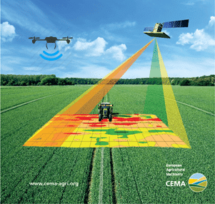
Another area of GIS application is in agriculture and farming practices. Farmers use spatial analysis to compare the differences in soil type and rainfall patterns within their agricultural land to assist with managing crops and drainage planning to prevent floods and droughts, leading to optimal crop yield. Farmers also use remote sensors through satellites to improve cultivation planning and decision-making to maximize crop yields. (https://smallfarms.cornell.edu/2017/04/use-of-gis/)